username
X
password
register
for free!
help
ArticlesGuidesRoutes
 
Photosets
 
 Comments
triplogs   photosets   labels comments more
Panorama Peak - Goldfield Mountains - 7 members in 13 triplogs have rated this an average 3.7 ( 1 to 5 best )
13 triplogs
login for filter options
Jan 20 2024
avatar

 Guides 1
 Routes 168
 Photos 384
 Triplogs 161

32 male
 Joined Aug 13 2017
 Tempe
Trans Goldfield Alternate, AZ 
Trans Goldfield Alternate, AZ
 
Hiking avatar Jan 20 2024
clayncallawayTriplogs 161
Hiking11.75 Miles 2,654 AEG
Hiking11.75 Miles   9 Hrs   13 Mns   1.46 mph
2,654 ft AEG   1 Hour   10 Mns Break
 
1st trip
Not really sure what to call this one. Settled on "Trans Goldfield Alternate". The original Trans Goldfield hike has been on the radar for a couple years. A few weeks ago, my hiking buddy suggested an alternate route going from N>S or S>N instead of W>E. I scouted Rhyodacite last week and this was the day to test it out. This route hits Dome, Panorama Peak, Peak 3076, and Rhyodacite Canyon.

The path up to Dome was surprisingly faint considering it is the high point. The way up wasn't bad and the eastern facing rock walls lit up in that classic gold color in the morning light. After signing the summit register we hopped down to the tanks and wrapped around some larger walls to start the trip over to Panorama. The way out to Panorama was less difficult than expected.

On the eastern side of Panorama we found a set of "2024" Balloons trapped in some brush. If you have ever wondered where balloons end up when you let them go into the sky, the answer is the Tonto National Forest. I am pretty much a balloon collector at this point. The 2024 balloons finally met their end at the hands of my trekking polls. I packed them up and we continued to Peak 3076.

Up until this point, we used gps routes posted on this site. I used the official route for Dome Mountain Loop and once on top of that I switched to DixieFlyer's alternate route that included Panorama Peak (thank you). With no route to go on, I switched over to a few screengrabs I had taken in Google Earth 3D. Minimally bushwacky, very doable. It took just under 4.5 hours to hit Peak 3076 from Wolverine Gate. The original plan was to backtrack a bit and use a ridge to go down and connect with the original Trans Goldfield route. Instead of doing that, we took a more direct route. It was steeper but manageable.

Things didn't slow down until we connected with the original route. From mile 6.5 - 7 it was snails pace. Lots of catclaw. Very overgrown. In this section there are some very interesting overhangs or caves or whatever you would like to call them. After that little slog, it was back through Rhyodacite (where I was the week before), out and around the bald eagle stuff and back to the car.

These miniature thru hikes are a good challenge. I think the only two left in the Phoenix metro area to knock off are the White Tanks (eh) and the Sierra Estrella ridgeline. Trips like this never go how you think they are going to go. Connecting the peaks on this one ended up being the easiest part.

Cool trip. Lots more to do in the Goldfields.
 Culture
 Culture [ checklist ]
[ checklist ]  Balloon
_____________________
 
Jan 29 2022
avatar

 Guides 41
 Routes 1,626
 Photos 14,983
 Triplogs 2,760

69 male
 Joined Jan 20 2009
 Far NE Phoenix,
Windy Dome Bushwhack Loop, AZ 
Windy Dome Bushwhack Loop, AZ
 
Hiking avatar Jan 29 2022
The_EagleTriplogs 2,760
Hiking12.69 Miles 3,005 AEG
Hiking12.69 Miles   8 Hrs   4 Mns   1.82 mph
3,005 ft AEG   1 Hour   6 Mns Break14 LBS Pack
 
1st trip
Route Scout Route Recorded  on Route Scout | Pop | Map | Popup | MapDEX
I like to try new things, and I have not spent much time in the Goldfields. I know that Joe prefers traveling across the valley to do the Goldfields over he Supes, loves bushwhacking and give him a high wind condition, and he is as happy as a clam. Who am I to deny him all this. Wally joined us and Denny was a now show because he was hitting up the Night Club and beach scene in Miami for the weekend.

I cobbled together a bunch of tracks to take us on a tour of the Goldfields including both Dome Mountains.

We walked through the unlocked and open gate around 7:30 and immediately talked to a hiker who said he was just returning from hiking to Dome Mountain. Joe got all excited when he commented at how windy it was.

FR10 was a nice way to warm up the joints for the climb later. We passed a few people camping but only one Jeep on the move. We hit up a minor cave and a couple of small arches before making our climb up the drainage up the west side to the saddle of the Domes. It's a steady climb, lots-o-bolder hopping and prickly stuff to avoid. It's very slow going. Joe was happy as a clam all the way up. I think he sang every Disney song in the catalog.

Up at the saddle, we took a break out of the wind and contemplated our next move. We ditched the idea of climbing to the lower Dome Mountain. It was into the strong wind. We were afraid that Joe would go all Sally Fields on us, turning into the Flying Nun and whisk his way off the mountain.

We hit up Dome 3381 to the north before retreating down to the Tiki Bar guzzler called Goldfield Two.

After lunch and Joe's conversation with a crow, we started the ridgeline portion of this hike. This was much better (and easier) than expected.

Now we got to the part that got Joe most excited. We got to a point where we decided to take a shortcut. Joe needed to get home for his Saturday afternoon waxing. (I did not ask) We cut down a canyon that was easy peazy to begin with. It got thicker, steeper, pokier and rockier. I've never seen Joe happier.

At the bottom of the canyon he wanted to stretch the hike info some thing longer, but Wally and I talked him out of it.

We finally hit some nice trails the roads for the return to the TH. The Goldfields really have some excellent views and options. I would not be surprised if this was the new daily Piestewa hike for him.
 Fauna
 Fauna [ checklist ]
[ checklist ]  Millipede
_____________________
There is a very fine line between "hobby" and "mental illness."
Dave Barry 🦅
  2 archives
Feb 20 2021
avatar

 Guides 13
 Routes 38
 Photos 1,651
 Triplogs 577

60 male
 Joined Nov 15 2005
 Jackson, CA
Dome Mountain LoopPhoenix, AZ
Phoenix, AZ
Hiking avatar Feb 20 2021
toddakTriplogs 577
Hiking13.00 Miles 3,500 AEG
Hiking13.00 Miles   7 Hrs   30 Mns   1.73 mph
3,500 ft AEG
 no routesno photosets
1st trip
Partners none no partners
Pretty good clockwise lasso loop combining the 2/4/18 @chumley and the 1/18/18 @DixieFlyer routes to hit Peaks 3269, Dome and Panorama, starting from the Bulldog gate. Great views but a lot of bushwhack, especially dropping off Panorama. If there ever were a next time, I would do the standard Dome Mtn route and then do the other two as out-and-backs from there.
_____________________
 
Dec 14 2019
avatar

 Guides 99
 Routes 1,485
 Photos 16,072
 Triplogs 1,375

male
 Joined Jan 07 2017
 Fountain Hills,
Goldfield Peaks: Dome-Panorama-3269-3239-3192, AZ 
Goldfield Peaks: Dome-Panorama-3269-3239-3192, AZ
 
Hiking avatar Dec 14 2019
DixieFlyerTriplogs 1,375
Hiking8.60 Miles 2,933 AEG
Hiking8.60 Miles   6 Hrs   21 Mns   1.73 mph
2,933 ft AEG   1 Hour   22 Mns Break
 
Partners none no partners
I did this hike solo last month, and decided to do it again today and take a few peeps with me.

It was a great day to be in the Goldfields -- the weather was super and we didn't see anyone else while on the hike.

We went to 5 of the highest 10 peaks in the Goldfields, including 4 of the top 5 and the 2 highest(Dome and Panorama).

There was a lot of off-trail hiking, which was fun...but it made for some slow hiking.

We drove in from the Wolverine Pass Gate for a couple of miles and parked at the Dome Mountain Trailhead. The gate was open both coming in and going out, and I shut and locked it both times.

As far as I am concerned, the Goldfields are an undiscovered gem!
_____________________
Civilization is a nice place to visit but I wouldn't want to live there
  3 archives
Jan 10 2019
avatar

 Routes 16
 Photos 628
 Triplogs 45

72 male
 Joined Apr 03 2011
 Mesa, Az
Panorama Peak - Goldfield MountainsPhoenix, AZ
Phoenix, AZ
Hiking avatar Jan 10 2019
gmaclachlanTriplogs 45
Hiking6.70 Miles 1,800 AEG
Hiking6.70 Miles
1,800 ft AEG
 
1st trip
Linked   none no linked trail guides
Partners none no partners
Went to Panorama Peak with a few friends. Drove to the big wash on FR10?? south of the gate on SR88, then struck out east for a high saddle. Over the top we looped as best we could CCW on the ridge but soon found ourselves dropping down to cross a wash/canyon and then back up to the ridge between Dome mountain and Panorama. Made it there for lunch and then continued our CCW loop for a bit. The terrain once again forced us down off the ridge and we basically bee-lined back to the original saddle and back down to FR10. Not a bad hike for vegetation, yes most of us were a bit bloody on arms but that's to be expected off trail. Good workout for the distance and the view is pretty good.
 Fauna
 Fauna [ checklist ]
[ checklist ]  Tarantula
_____________________
 
Jan 18 2018
avatar

 Guides 99
 Routes 1,485
 Photos 16,072
 Triplogs 1,375

male
 Joined Jan 07 2017
 Fountain Hills,
Dome Mountain LoopPhoenix, AZ
Phoenix, AZ
Hiking avatar Jan 18 2018
DixieFlyerTriplogs 1,375
Hiking9.70 Miles 2,500 AEG
Hiking9.70 Miles   6 Hrs   37 Mns   2.19 mph
2,500 ft AEG   2 Hrs   11 Mns Break
 
1st trip
Partners none no partners
This a pretty cool hike -- the views atop both Dome Mountain and Panorama Peak were great!

I am not sure what to think about the Western Camouflage Tanks though -- I have read that they are used to provide water for wildlife, but I can't see how wildlife would get to the water in the tanks...but it is an interesting system to collect and store water

The trail up to Dome Mountain was easily followed, and using a GPS track I was able to easily get to the Camo Tanks, and from there get to Panorama Peak...but the descent down from Panorama Peak was not that great -- on this trip I followed the route posted by hikerdw...The last time that I did this hike I took a shorter route down Panorama Peak on the east side, and it was not that great of a descent either
_____________________
Civilization is a nice place to visit but I wouldn't want to live there
 
Nov 12 2016
avatar

 Routes 268
 Photos 2,969
 Triplogs 541

66 male
 Joined Aug 16 2009
 Mesa,AZ
Dome Mountain LoopPhoenix, AZ
Phoenix, AZ
Hiking avatar Nov 12 2016
hikerdwTriplogs 541
Hiking9.20 Miles 2,358 AEG
Hiking9.20 Miles   6 Hrs   5 Mns   1.76 mph
2,358 ft AEG      51 Mns Break
 
no photosets
1st trip
Partners none no partners
Back in the Goldfield Mountains for a second week to summit Dome Mountain, check out a second set of tanks, and take in the views from Panorama Peak, generally following CannondaleKid's route. The hike up to Dome Mountain went very quick, following a well marked trail. Some steep areas, but overall not bad. Very windy on top. From there the target was the tanks. Going around to the right was a no go so we went left, to the west. The trough was empty but everything looked in tack. Headed up to the saddle, Checked out a cave, back to the saddle, then down a bit on the other side, then made our ascent to the ridge and over to Panorama Peak. Since it was still windy, we dropped down off the peak a bit and had lunch while still enjoying the views. From there we continued across and down the ridge and then took the high side of a wash down off the ridge to make our return back. Not a bad decent off the ridge but did encounter some thick vegetation in spots. Overall a great hike.
_____________________
Expect to self rescue
 
Feb 28 2016
avatar

 Guides 10
 Routes 673
 Photos 7,281
 Triplogs 4,660

67 female
 Joined Nov 17 2008
 phoenix, az
Dome & Panorama, AZ 
Dome & Panorama, AZ
 
Hiking avatar Feb 28 2016
trekkin_geckoTriplogs 4,660
Hiking8.10 Miles 2,392 AEG
Hiking8.10 Miles
2,392 ft AEG
 no routes
1st trip
Partners partners
CannondaleKid
tibber
after seeing my comments on wanting to hike dome mountain, mark proposed a loop that took in both dome mountain and panorama peak
he also extended an invite to tibber and az lumberjack, with angela taking him up on it
met at the dome mountain trailhead, and mark drove us to the 1356 turnoff, saving a mile and a half road walk each way
about 3/4 mile on 1356, then another 3/4 mile on a cairned use trail up to a saddle
another half mile to the peak, again following a decent trail, complete with painted white lines
there are several other ways to get up there, but this trail makes for an easy summit of the highest peak in the goldfields
dropped off the west side and went down to the camo tanks
up to the ridgeline that led to panorama peak
small summit area, and great 360 views of the goldfields and superstitions
descended to the north, exploring some cool rock formations, then taking lunch on another little ridge
the rest of the hike was an off-trail tour of some areas to the north
beautiful vistas as we crested each ridge, more interesting lichen covered rock formations and some little caves
exited through a wash and topped out on the original saddle
two more peaks accessible from this saddle: 3134 and 2972
a nice tour of this range, and a reminder of how much there is yet to explore
good to meet and hike with cannondalekid
thanks for putting this together, mark
angela, glad you came along
_____________________
hazhole
 
Feb 28 2016
avatar

 Guides 44
 Routes 162
 Photos 24,766
 Triplogs 2,411

75 male
 Joined May 04 2004
 Mesa, AZ
Dome/Panorama Peak Loop, AZ 
Dome/Panorama Peak Loop, AZ
 
Hiking avatar Feb 28 2016
CannondaleKidTriplogs 2,411
Hiking8.10 Miles 2,392 AEG
Hiking8.10 Miles   8 Hrs   4 Mns   1.05 mph
2,392 ft AEG      20 Mns Break20 LBS Pack
 no routes
1st trip
Partners partners
tibber
trekkin_gecko
Here's another short one for you Lee... ;)

I love this loop so it was a treat to introduce Kelly & Angela to it. Fun hike, great views, although I doubt Angela would have called the last two bush-whacking descents as fun by any means.

I have to give Angela a LOT of credit for hanging in there shortly after a bout with the flu, and with no complaint... at least not loud enough that I heard. Great job!

No complaints from my ankle so I'm chomping-at-the-bit for more Goldfields Wandering.

Tibber will provide the videos...
 Named place
 Named place [ checklist ]
[ checklist ]  Dome Mountain  Fountain Lake
_____________________
CannondaleKid
 
Feb 28 2016
avatar

 Guides 21
 Routes 1,182
 Photos 36,858
 Triplogs 1,570

69 female
 Joined Feb 26 2004
 Phoenix, AZ
Dome Panorama Loop - Goldfields, AZ 
Dome Panorama Loop - Goldfields, AZ
 
Hiking avatar Feb 28 2016
tibberTriplogs 1,570
Hiking8.17 Miles 2,396 AEG
Hiking8.17 Miles   8 Hrs   8 Mns   1.45 mph
2,396 ft AEG   2 Hrs   29 Mns Break
 
1st trip
Partners partners
CannondaleKid
trekkin_gecko
Whew, that off-trail bushwhacking stuff can get pretty hard. I got invited to join Mark and Kelly for this little loop. Well it turned out to be little and mighty at the same time.

We met at the Bulldog Canyon Gate where Mark took us in the mile and 1/2 to our starting point. We enjoyed a nice warm-up on the road to where we headed off trail following cairns and little white lines for the journey up to Dome Mountain. We admired the scenery as the morning light made it look even more beautiful. Along the way Mark pointed out this chute way up there that we would be taking to attain the Summit :o . I was already worried about the elevation gain on this one but fortunately it comes in bits, some rather large bits mind you, but doable bits.

It was good to have the little white lines as a trail doesn't exist for the most part and it seems to zig and zag from time to time, but not necessarily where you would expect. Some sections were steep, some were steep and slippery but not bad; though I'm glad I had my poles out from the get-go. The views along the way really are quite something especially the higher you get when all of a sudden Weavers Needle is peeking above the horizon.

You definitely go up at quite an angle and the last chute area is no exception. Mark and Kelly took their time so that was helpful; especially since I was continually trying to catch up after trying to take pictures or trying to take movies on the go. I actually haven't even looked at the movies as I've been tied up doing other things. I'm really trying to get on top of all the genealogy information I have and pictures. I figure since I have acquired all of that info and I'm the only one that knows the people, I need to get it up on our Romain Homestead site for the ages; otherwise, it will all die with me and what good is that?!

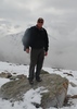
Oh, back to the hike. I was quite surprised after looking out to the west from a little viewpoint that all of a sudden I could see Kelly. Was she at the top already? She had to convince me and a couple more steps and there I was on top too, the tallest peak in the Goldfields. Wow, not bad :DANCE: . We hung out here for a bit as Mark pointed out some other landmarks and our route. We would head zigzagging down the west side of the mountain and then head slightly north to the Camo Tanks. I couldn't understand what HAZel was saying until I could finally see them in the distance. That's quite the set up. We checked it out and then headed east to a saddle. This was a nice part of the hike as it was mostly on bedrock.

Next we try to stay high as we head over to Panorama Peak. And then we stay on a bit of a ridgeline... all the time I'm worrying if we have to drop way down before attempting the second highest peak in the Goldfields. But we keep staying high and climb a little false peak that I thot was higher than it was before a little saddle and then up the north side with some scrambling at the end where two people could barely stand on the summit. And now, how do we get down from here. Well Mark had us swing a little to the right and we came down a side slope to the north and east. I could actually see the route they had taken as there seemed to be quite a bit of grass on this steep slope that fortunately had enough bush cover that you didn't have to worry much about sliding too far.

Once at level ground we checked out the area around the various rock outcroppings before Mark took us east again and then atop the rock outcropping for our lunch stop. Now just too bad the rest of the hike wasn't like this first part as it wasn't too bad. But from here on out, it wasn't a whole lot of fun but we did enjoy the scenery. It was also starting to get a little warmer as we made our way down toward another drainage and around, contouring above it for a couple times as we went up and down a few times to get over to the main wash we would be taking to hook up with the Dome Mountain route.
Well I decided to step on a rock Kelly had used to come down this one steep area but the rock gave out... and yes Mark, I heard the comment about the difference in weight thing ;) and fell sideways and ended up on my belly with my face in a grassy area. Well that was awkward. Kelly asked if she could help me get up as I contemplated how I was going to maneuver my body into an upright position. The grass was nice though so I was thinking maybe a little nap would be better :lol: . I got back up and then we continued on. I would slip two more times but both times I would land on my butt which makes it a lot easier to get up.

We passed by a couple areas with some rock outcroppings and alcoves. Mark pointed out where the critter caves were that he had been at earlier in the week. We finally made it to the wash and started hiking up it. We took a 10 minute break before finishing off the last 3/4 mile of the wash; I needed a little more fuel. We were finally getting closer to the area where we joined back up with the Dome Mountain route. I was quite happy about that as I was running out of steam. I know, I know, I had only gone not quite 7 miles but when you're out of hiking shape and it's mostly bushwhack; that just ain't easy :sweat: . This area where we join back up with Dome Mountain was pretty in the morning and it was pretty now.

From here to the road is quite spectacular :D and now we would see it at its best with the sun showing off the lichen on the mountain sides. I know I have my sunglasses on but it's like I needed an extra set as it was that bright as was the chuparosa blooms. I was glad to finally see the road but even it is a little steep and rocky in parts. And now to the beer, root beer for Kelly and Mark and a pumpkin beer for me. A good day out in the Goldfields. Thx Mark for touring us around, it was FAB. And thx to both of you for tolerating my whining and constant need to catch up again :budrose: ! Still recovering from significant bruising and swelling and scratches in my elbow area of my arm (fortunately not my Devil's Chasm elbow) as well as miscellaneous bruises acquired throughout this hike; badges of courage or clumsiness, not sure which :lol: .

I think the videos turned out pretty nice, finally ready to go 3-10-2016 except #7 is still stabilizing. Oh, the videos include the pictures I took:
Part 1 - Road walk and start of Dome route https://youtu.be/hx ... kxe8
Part 2 - route to Dome Mountain continues, Summit https://youtu.be/sr ... nbWU
Part 3 - Dome Summit down to tanks to saddle to ridgeline https://youtu.be/JI ... qXnI
Part 4 - to Panorama Peak summit https://youtu.be/7u ... aufQ
Part 5 - down from Panorama Peak https://youtu.be/gx ... Vr58
Part 6 - above the drainages toward the saddle https://youtu.be/xF ... QFfY
Part 7 - from the saddle to the TH https://youtu.be/2I ... HZ1I
 Flora
 Flora [ checklist ]
[ checklist ]  Chuparosa
_____________________
For me, sometimes it's just as much about the journey as the destination.
Oh, and once in awhile, don't forget to look back at the trail you've traveled.
  1 archive
Dec 03 2015
avatar

 Guides 44
 Routes 162
 Photos 24,766
 Triplogs 2,411

75 male
 Joined May 04 2004
 Mesa, AZ
In Search of Overlook Arch 3, AZ 
In Search of Overlook Arch 3, AZ
 
Hiking avatar Dec 03 2015
CannondaleKidTriplogs 2,411
Hiking9.90 Miles 3,104 AEG
Hiking9.90 Miles   6 Hrs   58 Mns   1.47 mph
3,104 ft AEG      15 Mns Break25 LBS Pack
 no routes
Linked   linked  
Partners none no partners
For this, my third In Search of Overlook Arch hike I decided to take a different approach. Since the Goldfield Mountain Hikes book said to 'look northwest (from Panorama Peak) to see the arch in the upper reaches of 3192 canyon' so I figured I'd try from above looking down instead of looking up from below. For this to work as I hoped, I needed to get to Panorama Peak early enough in the day to have the benefit of looking at shadows.

I began from FR 1356 in the Bulldog Off-Highway Recreation Area and followed the trail up the the saddle just east of Dome Mountain. Rather than the usual ascent up to Dome Mountain summit followed by the clockwise corkscrew loop down and around the western side before continuing across the ridge to Panorama Peak I decided to take a shortcut to cut off the additional 350' AEG of the usual route.

So much for a shortcut... sure it was .3 mile shorter, but with all the up-and-down crossing ridges and ravines the AEG was every bit as much and then some. Oh well, it's the first of a lot of new ground I will cover today. Once up to the ridge it was a reasonable jaunt over to Panorama Peak.

Just as was about to cross the last ridge to Panorama Peak I sensed 'something' so I stopped to listen while scanning the terrain for whatever it might be. After a full minute I had not figured it out, so I turned on my camera and zoomed it a little then used it to scan again. And as I swung it into the shade of Panorama Peak I see this deer staring at me. So I took a quick photo before attempting to get closer to shoot a video. While I did expect it to take off when I moved closer, I expected it would run away from me along a pretty obvious game trail but it came a bit toward me before making a quick turn and dropped out of sight on a steep slope within seconds, so I probably didn't get enough video to make it worthwhile.

Oh well, since I have the camera ready, I figured I'd shoot video of the are where the arch was said to be. Although I now had a better idea of the likely places, which must be visible from above as well as from the Salt River, I didn't spot any arch. Maybe I need to get closer, so I dropped down the northern slope of Panorama Peak and headed for Peak 3192. Once on the ridge of 3192 I took more photos and wandered along the ridge but found no arches along the ridge or below it.

It was originally part of my plan to continue north across the ridge then head down the right side of 3192 canyon, but with all the extra climbing and plenty of rough bush-whacking I wasn't prepared to add another thousand feet of climbing back up afterward. As it was, I didn't even want to climb back up to Panorama Peak, so I sought the shortest route down to the main drainage that I could follow all the way back up to the saddle east of Dome Mountain.

But again, in the Goldfields, there aren't many easy routes when attempting to find the shortest route. So I did more up-and-downs until finally reaching the drainage. As long as the drainage was clear it wasn't bad, but there were quite a few areas choked with debris and/or thick and thorny brush, so it was still a long slog back up to the saddle.

Once at the saddle I now had a trail to follow back to the Jeep. But about a half-mile from the Jeep I heard the sad howling of a dog, very much like what we heard a few days ago over on the Usery side of Bulldog. Again thinking of the lost dog we saw flyers for, I tried to locate the source. I got to a high point then stopped and listened and eventually heard a howl again and set off in that direction. Because the sound came from different directions as I moved around this went on for about 20 minutes, until I happened to look back over toward the trail and saw two dogs trotting up the trail. Oh great... that's the last time I go looking for a lost dog.

I have a feeling these dogs run loose pretty much wherever they want as I did not see another person the whole day or even in the Bulldog area on the drive out.

Ok, so IF I ever decided ONCE MORE to search for this elusive Overlook Arch, I'll take the same route I did for the first two attempts, at least it doesn't take over 3 hours just to reach the area like it did from this direction.
 Named place
 Named place [ checklist ]
[ checklist ]  Dome Mountain  Four Peaks
_____________________
CannondaleKid
 
Mar 29 2014
avatar

 Guides 44
 Routes 162
 Photos 24,766
 Triplogs 2,411

75 male
 Joined May 04 2004
 Mesa, AZ
Dome Mountain LoopPhoenix, AZ
Phoenix, AZ
Hiking avatar Mar 29 2014
CannondaleKidTriplogs 2,411
Hiking6.50 Miles 2,631 AEG
Hiking6.50 Miles   6 Hrs   30 Mns   1.03 mph
2,631 ft AEG      10 Mns Break25 LBS Pack
 
1st trip
Partners none no partners
After our hike to Panorama Peak from the western approach two days ago I decided to try a southern approach. I planned to follow the existing trail to the saddle between Peak 3134 and Dome Mountain then continue down into the canyon and eventually turn northwest and climb a winding ridge to a point just east of Panorama Peak then cross over to it.

Well, that plan lasted until I reached the saddle, when I spotted a freshly marked trail (with white painted lines & arrows no less) heading toward Dome Mountain. So, already with ideas of looping back from Panorama Peak to check out the Western Camouflage Tanks on the other side of Dome on my return from Panorama Peak, I figured I might as well make the loop clockwise instead of my original plan.

While the route-finding was simple as can be, the climb became more of a challenge the farther up I climbed. While traversing a northern-facing slope through some steep, loose spots I would have chosen a route following a few game trails just above the marked trail instead. (I've always believed critters are smarter than humans when it comes to trails)

Once past that slope the climb became rockier and steeper in direct proportion to altitude gain, but by simply taking it one step at a time, soon enough I was at the summit of Dome Mountain. A few photos and 360-pan video and I set off to find a route to the camouflage tanks to the west and 350' below. After reaching the northwestern end of Dome Mountain ridge with no route down, I backtracked halfway back toward the summit and dropped down the southwest slope and looped around first west then north until reaching the tanks, where I took the time to eat a PB&J.

After a quick look around the tanks I followed the two pipes up to their sources, two small dam-like 'catchments' whose purpose was to catch the water and pipe it to the tanks below. But with both almost completely filled with a sandy gravel their efficiency leaves a lot to be desired.

Whatever, time to move on, so I headed east up to the saddle before dropping down the other side just far enough to traverse the slope northward toward Panorama Peak. From there it was just a matter of following the top of the ridge in a wide arc gradually turning eastward until reaching Panorama Peak for the second time this week. Not quite as much haze as the last trip, but with plenty photos last trip I took few from the summit. (However, throughout this hike I'll take over 100 photos, as well as document over two hours of the hike on my GoPro)

From the summit I will descend along the route I had originally planned as the ascent. As it turned out, I'm sure it would have been a shorter ascent than the descent due to being cliff'ed out a few times, which after looking back each time I could easily have bypassed those spots without having to backtrack. But no matter, it just made for a bit more distance is all.

Once I reached the canyon floor it was just a matter of following the widest drainage up a half-mile to the saddle then following the trail back down to the start.

Although a distinctively warmer 87 degrees (instead of 73 a few days ago) I enjoyed it and look forward to more of the same to help get fully acclimated for when the triple digit temps arrive and I'll have the trails to myself... I can't wait!
:y:
Ok, ok... Tracey isn't into the high temps like me, so when she has a day off we'll be seeking higher elevations.

With 100+ photos & hours of video it'll take a while to sort through it all. I took just enough time to cut the extraneous backtracks from the GPS track, beginning from the parking area where FR1356 makes a 90-degree turn in Bulldog Canyon.
{Edit}
I posted 40 of the photos here on HAZ, the full 101-photo set is here:
http://changephoenix.com/jpserver/web/p ... php?id=693
Dome mountain summit video is here:
http://changephoenix.com/14/14-03-29DomeMountain.html
 Named place
 Named place [ checklist ]
[ checklist ]  Dome Mountain
_____________________
CannondaleKid
 
Mar 27 2014
avatar

 Guides 44
 Routes 162
 Photos 24,766
 Triplogs 2,411

75 male
 Joined May 04 2004
 Mesa, AZ
Panorama Peak - Goldfield MountainsPhoenix, AZ
Phoenix, AZ
Hiking avatar Mar 27 2014
CannondaleKidTriplogs 2,411
Hiking5.60 Miles 2,790 AEG
Hiking5.60 Miles   6 Hrs   5 Mns   0.98 mph
2,790 ft AEG      21 Mns Break25 LBS Pack
 
1st trip
Linked   none no linked trail guides
Partners none no partners
The original plan was an oval-shaped counter-clockwise loop beginning a little farther south, climbing a more direct route to Panorama Peak, then north to Overlook Arch if we could locate it, back down the drainage due west to FR #10 where we would follow it south back to the start. But after less than a mile into the hike we were greeted by a cliff face with no ascent route. We extended the loop a bit farther but with still no feasible route we chose to turn back and take what was to be our descent route.

Back to the Jeep we drove north a quarter mile to where there is more room to park and set off from there. Now some 2-1/2 hours later than our first start, we decided to fore-go a search for Overlook Arch and head directly to Panorama Peak.

With a GPS route of my previous descent of this particular drainage route-finding was no issue, although Tracey was not exactly enjoying some of the steep loose sections... one of which took four steps forward to actually gain one step forward. Having been up and down this drainage previously it was nothing new for me.

Once we hit the saddle at the top we took a glance in the direction of Overlook Arch and quickly agreed to skip it this trip and set out for the canyon floor. The canyon is more of a mildly-sloped bowl than anything so with the relatively open terrain the going was easy.

Although we knew where Panorama Peak was, it wasn't in view due to another hill in between. After a quick look at the terrain we chose to simply follow the dry wash on the canyon floor in a wide arc until reaching the saddle at the far end. As we began the climb at the end of the canyon, we looked up and saw a Turkey Vulture on a rocky outcrop with it's wings fully extended. Whether it was to warm itself in the sun or just to strut its stuff, who knows. All I know was my camera didn't have the zoom to get a good shot, and by the time Tracey got her camera out of my pack (she had put it there during the worst of the climb) it had pulled its wings in. We waited a few minutes for it to spread its wings again but gave up and put the camera away. Oh yeah, then it spread its wings again, only to fold them just before Tracey could get a shot. We only waited thirty seconds this time, when it flew off.

As we neared the end of the canyon the slope steepened and the going got a bit strenuous again so when we reached the saddle, Tracey said enough, you go on and I'll stay here. And as it turned out, where she picked her spot to wait gave her a view of Panorama Peak, which at that moment I thought was the high point in front of me. Only when I reached the 'top' would I realize it was a false-summit and I had another couple hundred yards to go. No big deal, a quick scoot across an easy saddle, winding a bit left which avoided a longer ascent up steep boulders and in moments I was at the top. There was no summit log, just a cairn and of course the awesome panorama! Unfortunately the gusty winds of the last two days left a dusty haze in the air so the photos left a lot to be desired... although to be sure, mere photos could never do justice to actually being there.

The rest of the hike was pretty much a breeze since any slope was downhill. (Tracey didn't quite share that sentiment... especially the spots were more a 'slide' than a breeze.) but it all turned out good, no bumps, no bruises, not even a lasting scratch.
(Hike stats include both the aborted hike and the successful hike)

YouTube video from the summit of Panorama Peak is here:
http://www.changephoenix.com/14/14-03-2 ... aPeak.html
_____________________
CannondaleKid
 
average hiking speed 1.51 mph

WARNING! Hiking and outdoor related sports can be dangerous. Be responsible and prepare for the trip. Study the area you are entering and plan accordingly. Dress for the current and unexpected weather changes. Take plenty of water. Never go alone. Make an itinerary with your plan(s), route(s), destination(s) and expected return time. Give your itinerary to trusted family and/or friends.

helpcommentissue

end of page marker