username
X
password
register
for free!
help
ArticlesGuidesRoutes
 
Photosets
 
 Comments
triplogs   photosets   labels comments more
Peak 3402 - Mormon Flat Dam Quad - 4 members in 6 triplogs have rated this an average 4.5 ( 1 to 5 best )
6 triplogs
login for filter options
Feb 05 2025
avatar

 Guides 99
 Routes 1,484
 Photos 16,072
 Triplogs 1,374

male
 Joined Jan 07 2017
 Fountain Hills,
Superstition Reds, AZ 
Superstition Reds, AZ
 
Hiking avatar Feb 05 2025
DixieFlyerTriplogs 1,374
Hiking7.96 Miles 2,430 AEG
Hiking7.96 Miles   7 Hrs   2 Mns   1.37 mph
2,430 ft AEG   1 Hour   13 Mns Break
 
1st trip
Route Scout Route Recorded  on Route Scout | Pop | Map | Popup | MapDEX
This was a hike to a couple of "red" peaks in the Supes:
1) Black Cross Butte 3351
2) Peak 3042

In the @azhiker456 vernacular, a "red" peak is one with 300+ feet of prominence.

I had never hiked either one of these peaks before.

Black Cross Butte 3351
I enjoyed this short hike which was on a pretty good trail. There were great views at the summit and on he north edge of the mesa looking down at the Salt River. We passed by the medicine wheel on the way to the north overlook.

Peak 3042
After leaving Black Cross Butte, we made our way over to Peak 3042. Along the way we stopped at Chalcedony Cave. The cave is easy enough to get to but it isn't terribly exciting, and I saw none of the namesake chalcedony. We were on a decent use trail much of the way over to Peak 3042. Rather than making a direct assualt of the peak from the south, which looked fairly steep and possibly cliffy, we looped around to the west and went up that way. There are some awesome views from the summit, especially from some overlooks on the north end, so this one was worth the effort to get there.

On the way back I made the not-so-brilliant decision to drop down into Crucifix Canyon. I imagine that the off-trail descent into the canyon was about 450 feet or so. It was steep in a few places and fairly brushy, but it wasn't all that bad. My motivation for going down there was to check out the Double Arches on the way back.

It was a very sunny warm day, and I was a bit tired going back through the canyon so we did not climb up to see the Double Arches. In fact, I could only see one arch from the bottom of the canyon (the sun was shining right in my eyes when looking up at the arches). The climb would not have been too bad, and it was probably 200 feet above the canyon floor. On a cooler day I would have gone up there, but as it was we were ready to be back at the TH.
 Geology
 Geology [ checklist ]
[ checklist ]  Natural Arch
_____________________
Civilization is a nice place to visit but I wouldn't want to live there
 
Jan 29 2025
avatar

 Routes 2
 Photos 6
 Triplogs 9

45 male
 Joined Mar 18 2012
 Mesa, AZ
Black Chalcedony 3042 Crucifix Arches Loop, AZ 
Black Chalcedony 3042 Crucifix Arches Loop, AZ
 
Hiking avatar Jan 29 2025
mistabenTriplogs 9
Hiking7.98 Miles 2,477 AEG
Hiking7.98 Miles   7 Hrs   53 Mns   1.35 mph
2,477 ft AEG   1 Hour   58 Mns Break25 LBS Pack
 
no photosets
1st trip
Route Scout Route Recorded  on Route Scout | Pop | Map | Popup | MapDEX
I had planned out a route with a core loop and 4 different spurs to bag:
  • the peak of Black Cross Butte
  • Chalcedony Cave
  • Peak 3042 3402
  • lower Crucifix Canyon
figuring that we could take or leave what we wished. I also had us going up the south side of the canyon to see the two big arches. The flexible plan worked out great but we did leave some unfinished business.

It had rained in the East Valley the night before. As we drove east on US-60 into Apache Junction we could see a little snow on the tops of the Superstitions and a lot of snow on Montana Mountain in the distance. FS 80 was in very good shape. Just after tcrowder, Phillip and I started out it began to drizzle.

It had stopped by the time we got to the first saddle. We left our packs there to summit Black Cross Butte and had great views all around, except that the entire Mazatzal range was above the cloud ceiling. We kept hoping for a view of Four Peaks covered in snow, but we never saw any of the Mazatzals. We never met anyone up there, but someone had left some distinctive gear next to the medicine wheel.

The geology started getting weirder as we approached Chalcedony Cave. Later, heading west around the peak containing the cave, we started seeing absurdly beautiful bits of chalcedony sticking out of rocks. A little further to the west they were everywhere loose on the ground. Bizarre and amazing.

I had prepared a rough route beforehand but it was imprecise enough where the trail was faint on satellite view that we wandered a little in a couple of places. I've left that in the route as an exercise for the reader.

On top of Peak 3402 we found a pile of rocks hiding a logbook inside. Nice work, @John10s! Ours was only the 3rd entry since your initial entry almost 2 years ago.

We were coming up against some time constraints so we did not see the lower part of Crucifix Canyon. Next time! The arches were fantastic. I had thought that from there we might loop behind the nearby spire and rejoin the canyon floor trail, but that was a long way down just to go back up to the car, so we opted to stay on that ridgeline as it curved back towards the FS-80.

We never met anyone but two or three times we saw a couple from a mile or more away. It was a great hike in a fantastic area.
_____________________
  3 archives
Mar 11 2023
avatar

 Guides 25
 Routes 376
 Photos 5,897
 Triplogs 346

40 male
 Joined Mar 01 2018
 Chandler, AZ
Black Cross Butte-Chalcedony Cave-Peak 3042, AZ 
Black Cross Butte-Chalcedony Cave-Peak 3042, AZ
 
Hiking avatar Mar 11 2023
John10sTriplogs 346
Hiking7.09 Miles 2,152 AEG
Hiking7.09 Miles   7 Hrs   29 Mns   1.33 mph
2,152 ft AEG   2 Hrs   9 Mns Break
 
1st trip
Route Scout Route Recorded  on Route Scout | Pop | Map | Popup | MapDEX
It was a cloudy but comfortable morning as we got started--one of the warmest mornings of the year so far. Our first destination was Black Cross Butte, and we could see a few campers set up below in one of the dirt pullouts off FR80. The sky stayed overcast most of the morning, but we had some nice views of the sunshine hitting the Superstitions and Goldfields during the first mile, and we could see the double arches across the canyon.

Once we were on top of Black Cross Butte, we visited the medicine wheel on the way to the north end for the views overlooking the Salt River, with Four Peaks hidden in thick clouds. We hiked south to the high point next, then started west toward Chalcedony Cave. Coming down off the butte, we passed a group of three hikers who were on on their way up.

I'd only previously seen the cave from a distance, and it looked shallow, but there was more to it than expected. The right and left sides both extend back beyond the exterior opening, and it's bigger than it looks from far away. We spent a few minutes there before the three hikers approached again. We packed up and let them enjoy the cave for themselves and took off four our next destination, Peak 3042, making our way southwest toward the saddle where the official 3042 route comes up out of Crucifix Canyon.

On our way, the three hikers approached again and passed us up on the hillside as we followed a drainage...it was starting to feel like they'd copied our itinerary for the day :). They asked if we were heading down into Crucifix Canyon, which they were, so we finally parted ways for good. Getting up to Peak 3042 was pretty straightforward--the narrow chute leading up toward the southern base of the mountain looked brushy from a distance, but there was enough rock that getting through that section didn't require picking up a bunch of scratches. TboneKathy waited in that area a few tenths of a mile from the peak while I made my way up. The final approach was a little steep but short, and the the rock wasn't too loose.

The views from the top were spectacular, looking across at Sheep Mountain and over toward Four Peaks, which was still in the clouds. The sun finally came out for a few minutes, so I got to enjoy the scenery with a variety of lighting. A few boats passed while I was up there, and I could see a kayaker on the river. Skull Cave was visible across from me, and I think I spotted Skeleton Cave to the northeast when I zoomed in.

No zoom: [ youtube video ]
With zooming: [ youtube video ]

I took a bunch of pictures, ate a snack, then headed back down to rejoin TboneKathy for the hike out. We stopped for lunch near the saddle where the route dropped into Crucifix Canyon but stayed up high and followed our same route back on the way out. Along the way, we saw our first rattlesnake of the season a few feet off the trail...it gave us plenty of warning and was far enough away to not pose a threat but close enough to get some decent pictures.

The parking area had really filled up when we got back--there were five other vehicles there, we saw a big group hiking down into Crucifix Canyon, two hikers starting up toward Black Cross Butte with a dog, and one hiker coming out behind us. Like so many places, this one seems to be gaining popularity, unfortunately. This was short hike but fun to see some new places, and the views were impressive. On the drive out, we pulled over and decided to hike to Coronado Mesa as clouds gathered to the north.
  1 archive
Jan 19 2019
avatar

 Routes 268
 Photos 2,969
 Triplogs 541

66 male
 Joined Aug 16 2009
 Mesa,AZ
Salt River Canyon View from Peak 3042Phoenix, AZ
Phoenix, AZ
Hiking avatar Jan 19 2019
hikerdwTriplogs 541
Hiking7.02 Miles 2,100 AEG
Hiking7.02 Miles   5 Hrs      1.68 mph
2,100 ft AEG      50 Mns Break
 
Partners none no partners
Really enjoyed this hike in a new area for us. I loaded the GPS route @adilling had posted last year expecting a lot of route finding however there is a pretty good use trail most of the way, fading out in only a couple spots. Saw one white-tail deer on our way to the peak. The views on top of 3042 were enjoyed while we ate our lunch. The drainage used to drop down to the canyon floor was a little overgrown at the top but eased up the lower we got. In the canyon on our way to the Double Arches we ran into Mike ( @te_wa ), Lisa ( @pickles ), and their daughter, whom we also chatted with back at the parking. The Double Arches were really niceto see up close, and easy to climb up to. Took a few pictures and then made our way back to the truck. This is a great area :y:
_____________________
Expect to self rescue
  1 archive
Jan 13 2018
avatar

 Guides 2
 Routes 267
 Photos 9,816
 Triplogs 402

62 male
 Joined Dec 02 2014
 Mesa, AZ
Salt River Canyon View from Peak 3042Phoenix, AZ
Phoenix, AZ
Hiking avatar Jan 13 2018
adillingTriplogs 402
Hiking7.84 Miles 2,194 AEG
Hiking7.84 Miles
2,194 ft AEG
 
Partners none no partners
We did a hybrid hike yesterday up to Peak 3042 and then down into Crucifix Canyon. We took the route up to the saddle via the Pickaxe Canyon Trail and then veered off and started following the route from Joe to the top of Peak 3042, then on the way down we followed CannondaleKid’s route down into Crucifix Canyon.

My goal was to get to the top of 3042 and then climb up to the double arch in Crucifix Canyon on the way back. Mission accomplished!

I was in this area with outdoor_lover in December and had quite the off trail adventure. This time around it was still an off trail bushwhack, but I learned some good lessons from the first trip in here.

We bypassed Black Cross Butte by skirting the butte to the saddle following the Pickaxe Canyon Trail. This was the only “trail” we had for most of the day. The rest was mostly off trail, with the occasional trail/game trail tossed in. This was an easy climb to the saddle.

The approach to 3042 was a little up and down but I have been there before, so we made good time. When we got the little saddle below 3042, we took a look at the drainage that CannondaleKid used, but opted for the less nasty side approach from Joe’s track. The climb up was nice and the little “Castle Rock” formation at the base was really cool. The rock was really loose and dangerous to climb, so we admired it for a few and then made the final assault to the top.

The views up on 3042 were really amazing. Four Peaks, the river, the canyons – all incredible. The light was harsh and there were no clouds to be seen, but it was still stunning. The wind on top was pretty strong as well.

We headed back down to find the drainage that CannondaleKid used to access the canyon below. That was a little hairy, but very manageable. Much better than the cliffs and rock climbing outdoor_lover and I had to navigate from my earlier trip.

We made it into the canyon, had a little snack and rest and then went looking for the arches. The climb up was not as bad as it looked. There is not really a trail, but there are lines in the landscape you follow along.

The arches were awesome! I have had these guys on my list for a while. It was great to finally get up and see them. The sun was playing a bit with the pictures, but I was able to get some nice pictures of these cool formations.

Down we went and back to the trailhead. The path up to the parking area for this hike is marked by a cairn right before the canyon turns south. The trail was sorta marked and sorta visible. We managed to make it up and back to the parking area.

An excellent off trail adventure. I really like this area. I think next time I will try the Pickaxe Canyon Loop. That one looks cool too!
_____________________
"Jobs fill your pockets, adventures fill your soul."

instagram: @andydilling
 
Jun 05 2014
avatar

 Guides 44
 Routes 162
 Photos 24,766
 Triplogs 2,411

75 male
 Joined May 04 2004
 Mesa, AZ
Peak 3402 - Mormon Flat Dam QuadPhoenix, AZ
Phoenix, AZ
Hiking avatar Jun 05 2014
CannondaleKidTriplogs 2,411
Hiking8.40 Miles 2,743 AEG
Hiking8.40 Miles   7 Hrs   41 Mns   1.17 mph
2,743 ft AEG      30 Mns Break27 LBS Pack
 
1st trip
Partners none no partners
On my Peak 3042 recon four days earlier I felt a route along the floor of the canyon from Forest Road 80 could very well be the best option. So I pored over the topo & satellite maps a bit more, planned a route with 3 options of where to ascend from the wash, of which it just so happened the least likely was closest to the trailhead and the best option was the farthest. With the route planned, I headed out the next chance I got.

Rather than start at the SRP gate on FR80, I drove down into the 'bowl' just below the road and parked next to a fire ring. From there I set out along a road of sorts for a few hundred feet to its end, then continuing along a faint trail, more like a game trail than anything else. But it was heading the direction I wanted to go so I followed it until it faded out while crossing the wash. From a hike I did 3 miles downstream 4 years ago I remembered there was a series of drops at the first corner of the wash. To avoid them I climbed to the right to a small saddle then descended a loose gravel slope back to the wash.

From there I continued along the canyon floor, rock and boulder-hopping most of the way, with some sections where I took shortcuts around corners through the few flat areas. Sometimes it wasn't worth the effort because the burrs and cats-claw were ready to crab hold of me. The burrs would be my nemesis any time I went through brushy areas.

I passed by my first, but least likely ascent route option, which may have been nice game trails higher up, the lower slope was bad news so I continued. The second option provided a few possibilities but would entail lots of back and forth, so again I continued on. But the moment I laid eyes on ascent option #3 I knew it was the best option by far. Besides, it was very close to being on a straight line the wash to Peak 3042.

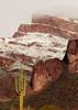
So, at 1.3 miles from the TH I turned right, following a relatively wide drainage about 500' up to the ridge/saddle. Wow! The views in all directions were great, yet I sensed it was just a hint of what was to come.

With a hill immediately ahead blocking view of my planned route, I wasn't sure whether to follow the route I mapped out by satellite view or not, so took a slight detour to climb the hill for a better look. It was another nice view but I was more interested in the fact it re-affirmed my route choice. I dropped back down and curved back onto my original route, which just happened to parallel some game trails so I followed them to the next ridge, where again I ascended a smaller hill for another gander at the terrain ahead. Again I found my original route had nailed it pretty well so I decided to stop second-guessing myself and just follow the planned route, which I did until the next point where I had mapped two routes to the summit.

The first was straight up a drainage, one that satellite view didn't give me much hope, or the second option, which would have added close to a mile to the round-trip. Always seeking the shortest route, I chose the drainage. It began quite steep but after that it was just a matter of winding back and forth up and around the obstacles and it was a piece-of-cake!

Now up on the wide mesa I simply set my GPS to point the way to the summit and set off up the slope. I took a route between a prickly pear thicket on the left and a cholla forest on the right. I found it easier to go through the cholla as I didn't have to wind around as much as thorough the prickly pear. A relatively easy 300' ascent and I was up top.

I took the usual summit pan photos and videos with both my Olympus & GoPro (which I had used to film the final ascent as well), and settled in for my PB&J lunch. After the short break I wandered around the summit taking a number of photos near the edges of the flat summit. I thought of taking a lot more time wandering around some of the lower slopes, but having accomplished reaching the goal easier than expected, after I mulled over a few thoughts I decided to head back. My decision was made due to three things:
1. I'll return again soon for a more thorough look
2. I wanted to scout out a route to Black Cross Butte
3. I wanted to check out some debris I saw in the wash below where I was at 4 days earlier.

So I headed back on the same route until I hit the canyon floor 1.3 miles from the TH, where I turned the other direction. Unfortunately I didn't have the waypoint to the large piece of tinted glass or plexiglass, but figuring it was about a half-mile along the dry creek bed that seemed to be easy enough. But of course, that distance was a direct line and after a mile along the meandering creek I found I wasn't even halfway there so I turned back. But this added side trip meant I added two miles and almost two hours to the hike, and for the first time in a LONG time, I ran out of water just under 2 miles from the TH and it was getting a bit toasty.

Ok, now I'm just taking it easy, and stopping under every boulder that provided shade and a slight breeze, yet realizing the longer it took to get back the more dehydrated I'd be. So I tried to keep moving. With just a half-mile to the end my legs started to cramp bad just when I had to climb a steep slope to avoid the 40' dry fall. To finish the climb I had to pull myself up with my arms using my hiking poles. Once over that obstacle I had to focus on every step just to keep from stumbling on the rough and rocky creek bed.

It felt great to reach the Jeep... the ordeal was over, I popped open the cooler, downed a good 32 oz my mix and filling two 16 oz bottles to drink from on the drive home. Good thing, because from Tortilla Flat it was the slowest I'd EVER driven back down Apache Trail due to someone in an SUV driving 10-20 MPH ALL the way down to to Needle Vista on 88, where he proceeded to take off like a shot, well over the limit... I think he was just messing with all of us following in line behind.

But no matter, the views on the hike were awesome and made it all worthwhile, and I will be heading back soon, only with either enough fluids for an ALL-DAY hike, or stick to closer to my plan, which had been about 3 miles and 2 hours shorter. (I had enough fluid for that!)

I posted 50 photos on HAZ, the full set of 82 is on my site as usual.

Peak 3042 summit panorama video:
https://www.youtube.com/embed/o9JkVkogCWc
_____________________
CannondaleKid
 
average hiking speed 1.38 mph

WARNING! Hiking and outdoor related sports can be dangerous. Be responsible and prepare for the trip. Study the area you are entering and plan accordingly. Dress for the current and unexpected weather changes. Take plenty of water. Never go alone. Make an itinerary with your plan(s), route(s), destination(s) and expected return time. Give your itinerary to trusted family and/or friends.

helpcommentissue

end of page marker