|
| | | |
| |
|
| Canyoneering | 7.50 Miles |
2,500 AEG |
| | Canyoneering | 7.50 Miles | 6 Hrs 45 Mns | | 1.11 mph |
| 2,500 ft AEG | | | | |
|
|
| | Canyon Hiking - Non-technical; no rope; easy scrambling; occasional hand use | | A - Dry or little water; shallow or avoidable water; no wet/dry suit | | III - Normally requires most of a day |
| |
| Linked |
|
none
[ show ]
| no linked trail guides |
| Partners |
|
none
[ show ]
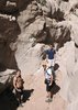
| no partners | | Thanks to sk44 for posting this trail writeup and putting this canyon on my radar! Though I just have my car right now, so I had to get a little creative on the approach .  I decided to park alongside AZ288 due west fo Klondike Mt and hike up to the saddle just to the south of that peak. From there I dropped down towards Pinal Creek Canyon with a few route options in front of me... Right canyon, left canyon, far right or far left. I decided to park alongside AZ288 due west fo Klondike Mt and hike up to the saddle just to the south of that peak. From there I dropped down towards Pinal Creek Canyon with a few route options in front of me... Right canyon, left canyon, far right or far left.  I first choose left canyon and ended up leaving a couple fixed ropes in place at a 40-50ft drop & 20ft drop. I could have done a longer bushwhacking bypass around these drops, but this was an exploratory trip and I wanted to see how this canyon played out. It eventually ended with a 120-150ft drop I first choose left canyon and ended up leaving a couple fixed ropes in place at a 40-50ft drop & 20ft drop. I could have done a longer bushwhacking bypass around these drops, but this was an exploratory trip and I wanted to see how this canyon played out. It eventually ended with a 120-150ft drop  down to Pinal Creek and with the 200ft rope back in the car, I figured I'd try one of the other options. I had a decent vantage point from that dropoff to scout the other options out and could see that the right canyon wasn't much better with another big drop. I ascended back up the two ropes and headed south to hit up the far right option. I lucked out and was able to find a not-too-insane spot to scramble down with using any ropes. I was originally planning on do this as an out & back, but now that I was able to get down w/o leaving any gear behind I was thinking I'd try to loop it back via the bridge & AZ288. While hiking downstream, I was now able to scout out the far left option and feel that would have been my best way down. The hike downstream was fairly pleasant with nothing too difficult to deal with and some nice scenery to soak in and before I knew it I was at the Salt River. The AZ288 bridge was only a half mile away, but walking alongside the bank was not an option with the river right up against a huge 200-300ft cliff. Plan C was to just throw on my shorty wetsuit still in my pack and float down the frigid river, but I figured I'd try plan B first and climb up Klondike Butte up and over the cliff. After I got above the cliff, I was able to scout an easy way down to another side canyon and lucked out and found an old trail that led straight to the bridge. down to Pinal Creek and with the 200ft rope back in the car, I figured I'd try one of the other options. I had a decent vantage point from that dropoff to scout the other options out and could see that the right canyon wasn't much better with another big drop. I ascended back up the two ropes and headed south to hit up the far right option. I lucked out and was able to find a not-too-insane spot to scramble down with using any ropes. I was originally planning on do this as an out & back, but now that I was able to get down w/o leaving any gear behind I was thinking I'd try to loop it back via the bridge & AZ288. While hiking downstream, I was now able to scout out the far left option and feel that would have been my best way down. The hike downstream was fairly pleasant with nothing too difficult to deal with and some nice scenery to soak in and before I knew it I was at the Salt River. The AZ288 bridge was only a half mile away, but walking alongside the bank was not an option with the river right up against a huge 200-300ft cliff. Plan C was to just throw on my shorty wetsuit still in my pack and float down the frigid river, but I figured I'd try plan B first and climb up Klondike Butte up and over the cliff. After I got above the cliff, I was able to scout an easy way down to another side canyon and lucked out and found an old trail that led straight to the bridge.  From there it was a super easy road walk back to my parking spot, esp since hardly anyone uses this 'highway to nowhere'. From there it was a super easy road walk back to my parking spot, esp since hardly anyone uses this 'highway to nowhere'.  |
| _____________________
| Yea, canyoneering is an extreme sport... EXTREMELY dramatic!!! =p |
| | |
|
|
|
 Route Editor