username
X
password
register
for free!
help
ArticlesGuidesRoutes
 
Photosets
 
 Comments
triplogs   photosets   labels comments more
Escondido Trail - MMRP - 5 members in 68 triplogs have rated this an average 2.6 ( 1 to 5 best )
1, 2, 3, 4  Next
68 triplogs
login for filter options
Dec 26 2023
avatar

 Guides 27
 Routes 669
 Photos 12,096
 Triplogs 856

56 male
 Joined Jul 05 2006
 Mesa, AZ
Escondido Trail - MMRPPhoenix, AZ
Phoenix, AZ
Hiking avatar Dec 26 2023
DarthStillerTriplogs 856
Hiking11.07 Miles 1,129 AEG
Hiking11.07 Miles   4 Hrs   13 Mns   2.63 mph
1,129 ft AEG
 
1st trip
Partners none no partners
I was planning to do this hike last month but when I started the lightning storms from the night before hadn't quit yet, so I modified it. This time I got the loop in and also did Lousley Hill, which has really nice 360 views. Dark when I started, sunny but still cool when I finished. Felt noticeably cooler on Lousley Hill. Not much traffic on the trails since it was a Tuesday, busier when I finished up.
_____________________
 
Nov 27 2023
avatar

 Guides 116
 Routes 337
 Photos 11,399
 Triplogs 894

63 male
 Joined Dec 20 2010
 Sunnyslope, PHX
Shallmo Wash Trail - MMRPPhoenix, AZ
Phoenix, AZ
Hiking avatar Nov 27 2023
kingsnakeTriplogs 894
Hiking9.97 Miles 793 AEG
Hiking9.97 Miles   3 Hrs   15 Mns   3.07 mph
793 ft AEG
 
1st trip
Partners none no partners
Starting at the Horse Staging Area, today’s plan was to hike all of Shallmo Wash Trail, a wee bit of Pemberton Trail and all of Escondido Trail.

I started hiking just after 8:00 a.m., when the late autumn sun was still relatively low in the sky. The clouds were wispy, laced with contrails. The temperature was 58℉, and breezy, so I wore my hoodie.

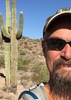
Shallmo Wash Trail is hard. More like cement than dirt. Firm & fast singletrack. I took my best pictures of the day along it: Clouds, low-angle sun shots, and saguaro cactus.

I don’t recall seeing a single saguaro along Pemberton. I did see about a half dozen MTBs. Hoping to add something interesting to my video, I stopped at a small wood bridge waiting for an MTB to roll by for a finger quotes “action” shot. Twenty minutes I waited. No bueno. Of course. 🙄

The sky had become totally overcast, so even though the temperature had ostensibly increased, I kept my hoodie on.

Just after 10:00 a.m., I turned onto Escondido. It starts heading east along the north edge of the mesa. The next two miles are downhill. A couple of MTBs preceeded me, but I didn’t see another one the remainder of my hike. At the bottom of the descent, the trail turns south. It becomes rolling and very twisty as the MTB-optimized route is squeezed between the mesa and McDowell Mountain Rd. If you need a bail, the trail is never more than ⅓ mile from the heavily-trafficked road, and sometimes as close as 200 yds. Most of this hike’s elevation is in this section, in the form of many 50-80 ft. / 4-5% slope climbs.

It would probably be a blast to ride Escondido, but hiking it got to be drudgery without something, anything, to photograph. Maybe in April, when the flowers bloom, it might be better. Oh well: Miles is miles.

Rumble Video: https://rumble.com/v3z17uq-hiking-mcdow ... -park.html
Vimeo Video: https://vimeo.com/890301649
 Flora
 Flora [ checklist ]
[ checklist ]  Saguaro
 Named place
 Named place [ checklist ]
[ checklist ]  Four Peaks
wildflower observationwildflower observationwildflower observationwildflower observationwildflower observation
Wildflowers Observation None
lol
_____________________
http://prestonm.com : Everyone's enjoyment of the outdoors is different and should be equally honored.
  1 archive
Nov 18 2023
avatar

 Guides 27
 Routes 669
 Photos 12,096
 Triplogs 856

56 male
 Joined Jul 05 2006
 Mesa, AZ
Pemberton Trail - MMRPPhoenix, AZ
Phoenix, AZ
Hiking avatar Nov 18 2023
DarthStillerTriplogs 856
Hiking10.33 Miles 575 AEG
Hiking10.33 Miles   3 Hrs   58 Mns   2.60 mph
575 ft AEG
 
This was an exercise in backup plans. Stayed local to hike due to the weather, specifically the threat of lightning. I went up to McDowell Mtn park with the intent that I would have bailout options in the event of lightning. This became an issue almost immediately as I hiked over to the Shallmo Wash Trail from the main staging TH. I had intended to do a big loop with the Shallmo Wash and Escondido trails, but by the one mile mark, I decided to head back to the TH as a cell moved in nearby and the lightning and thunder became more frequent. By the time I got back to the TH, the cell moved and the skies were much lighter. I decided to head out north on the Pemberton Trail with the same idea of going out and back. I continued on this plan with this and the Scenic and Tortoise Trails and then finished up with the Hilltop Trail, which I had never hiked before. I started out thinking I might only get a 2 mile hike in, but I finished up with over 10 for the day. There was no other lightning nearby after that initial cell went through, so I could have done my original backup plan. Nothing special, but the scenery was nice and a little different with the clouds rolling through the mountains.
_____________________
 
Oct 25 2023
avatar

 Routes 189
 Photos 7,236
 Triplogs 1,740

57 male
 Joined Apr 25 2011
 Goodyear, AZ
MMRP Angry Coyote Loop, AZ 
MMRP Angry Coyote Loop, AZ
 
Mtn Biking avatar Oct 25 2023
NightstalkerTriplogs 1,740
Mtn Biking28.60 Miles 1,753 AEG
Mtn Biking28.60 Miles   2 Hrs   35 Mns   11.52 mph
1,753 ft AEG      6 Mns Break10 LBS Pack
 
1st trip
I've been dying to take the gravel bike out to MMRP for a spin. Didn't want to brave the weekday cross town traffic, but the parks has events scheduled for the next few weekends, so today is the day! Did the Angry Coyote Loop (Cinch, Scenic, Pemberton, Escondido, Verde, Pemberton, Delsie, Bluff, Pemberton, Tonto Tank, Pemberton, Lower Shallmo Wash counter clockwise) and finished it off with a lap around the Sport Loop on the competitive track. The Aravaipa Running club is setting up for it Javelina Jundred race this weekend. Lots of bikers and hikers out on the trails this morning. It was a great ride on the Cutthroat.
 Meteorology
 Meteorology [ checklist ]
[ checklist ]  Fire Burn Area & Recovery
_____________________
 
Dec 06 2021
avatar

 Guides 3
 Routes 40
 Photos 47
 Triplogs 60

56 male
 Joined Jul 04 2016
 Phoenix, AZ
Pemberton Trail - MMRPPhoenix, AZ
Phoenix, AZ
Hiking avatar Dec 06 2021
tdwoodTriplogs 60
Hiking6.13 Miles 510 AEG
Hiking6.13 Miles   2 Hrs   56 Mns   2.47 mph
510 ft AEG      27 Mns Break
 
no photosets
1st trip
Partners none no partners
Route Scout Route Recorded  on Route Scout | Pop | Map | Popup | MapDEX
On my last visit to Cave Creek Regional Park, I purchased one of them nifty annual passes for the Maricopa County Parks System. Time to get my money's worth, by gum! I figured I would visit them in clockwise fashion starting from CCRP and immediately goofed the plan all up by visiting McDowell Mountain RP next, forgetting that Spur Cross Ranch Conservation Area is also part of the system ](*,)

As an iOS Route Scooter, this was also an opportunity to help the dev team by putting RS through some tests. I only had one issue where, after deviating from the downloaded route, RS couldn't find me again when I returned to it at a point further along. Closing and reopening the app did the trick.

Initially, I had intended to do a return loop on Scenic Trail but wasn't ready to start back so soon.

At the start, Pemberton had a bit more MTBs than I'm comfortable with, which is really any number at all. A childhood incident where I was hit by a cyclist from behind while walking still haunts me almost fifty years later and I find myself constantly looking over my shoulder. Maybe I should get one of those tiny little postage stamp sized rearview mirrors they use?

Escondido trail was much quieter. Only one cyclist and no other human sightings.

I had Lousley Hill all to myself. This seems like it would be a sweet spot to return to the next time there's snow on the mountains.

On the return, a nice bunch of wispy clouds provided some welcome diffusion of the sun's rays. Didn't see another soul until I got back on Pemberton.

I'll definitely return but would likely choose other options to minimize my time on Pemberton, being the main arterial route that it is.
_____________________
 
Dec 03 2021
avatar

 Guides 8
 Routes 70
 Photos 3,208
 Triplogs 273

59 male
 Joined Oct 07 2017
 Chandler, AZ
Escondido Trail - MMRPPhoenix, AZ
Phoenix, AZ
Hiking avatar Dec 03 2021
YoderTriplogs 273
Hiking9.80 Miles 900 AEG
Hiking9.80 Miles   2 Hrs   59 Mns   3.38 mph
900 ft AEG      5 Mns Break10 LBS Pack
 
Partners none no partners
Did this 9.8 mile loop as a night hike back in June. Thought I would check it out during the day. Honestly, this is better as a night hike. Although it probably has some of the best views in the east side of the park, it's not really very interesting overall.

We started Friday morning pre-dawn, and encountered two hikers and one biker near the end of the hike.

I'll post the GPS route if anyone is interested in doing this as a loop.
_____________________
J. Yoder
 
Jul 03 2021
avatar

 Routes 189
 Photos 7,236
 Triplogs 1,740

57 male
 Joined Apr 25 2011
 Goodyear, AZ
MMRP Escondido Scenic Loop, AZ 
MMRP Escondido Scenic Loop, AZ
 
Mtn Biking avatar Jul 03 2021
NightstalkerTriplogs 1,740
Mtn Biking13.90 Miles 1,047 AEG
Mtn Biking13.90 Miles   2 Hrs   49 Mns   6.18 mph
1,047 ft AEG      34 Mns Break8 LBS Pack
 no routes
1st trip
Carey and Dan joined me for a great loop at MMRP. Did some sessioning on the skills loop afterwards.
_____________________
 
Jun 12 2021
avatar

 Guides 8
 Routes 70
 Photos 3,208
 Triplogs 273

59 male
 Joined Oct 07 2017
 Chandler, AZ
Escondido Trail - MMRPPhoenix, AZ
Phoenix, AZ
Hiking avatar Jun 12 2021
YoderTriplogs 273
Hiking11.10 Miles 1,371 AEG
Hiking11.10 Miles   4 Hrs   12 Mns   3.40 mph
1,371 ft AEG      56 Mns Break10 LBS Pack
 
Partners none no partners
Another Night Hike:
Combine Escondido , some Pemberton, Scenic and Cinch trails for a 11.1 mile loop.

Started at about 10pm and finished up at 2:10am.
_____________________
J. Yoder
 
Nov 01 2020
avatar

 Routes 5
 Triplogs 6

female
 Joined Apr 26 2020
 Az
Escondido Trail - MMRPPhoenix, AZ
Phoenix, AZ
Mtn Biking avatar Nov 01 2020
JdurhmanTriplogs 6
Mtn Biking10.25 Miles 666 AEG
Mtn Biking10.25 Miles   2 Hrs   24 Mns   4.80 mph
666 ft AEG      16 Mns Break
 
no photosets
1st trip
Linked   none no linked trail guides
Partners none no partners
Route Scout Route Recorded  on Route Scout | Pop | Map | Popup | MapDEX
Did overheat and had to walk a little. 81 when we started 88 when done.
 
Dec 31 2019
avatar

 Guides 9
 Routes 33
 Photos 780
 Triplogs 4,634

44 male
 Joined Nov 25 2008
 Scottsdale, AZ
North Trail - MMRPPhoenix, AZ
Phoenix, AZ
Run/Jog avatar Dec 31 2019
BoonemanTriplogs 4,634
Run/Jog11.25 Miles 436 AEG
Run/Jog11.25 Miles   1 Hour   22 Mns   8.23 mph
436 ft AEG
 no routesno photosets
1st trip
Partners none no partners
I did it, I made it to 2,500 miles for 2019! My legs were definitely feeling it these past two weeks as I have been averaging almost 10 miles per day in December. Not sure why I was aiming for that number, just sounded like something fun to do to end the year.
_____________________
 
Jul 12 2019
avatar

 Guides 3
 Routes 25
 Photos 2,216
 Triplogs 237

63 male
 Joined Apr 22 2012
 Fountain Hills,
Escondido-Pemberton-Scenic - MMRP, AZ 
Escondido-Pemberton-Scenic - MMRP, AZ
 
Hiking avatar Jul 12 2019
KBKBTriplogs 237
Hiking10.52 Miles 846 AEG
Hiking10.52 Miles   3 Hrs   43 Mns   2.94 mph
846 ft AEG      8 Mns Break24 LBS Pack
 no routes
Partners none no partners
On Friday, the 12th, I did a loop hike in MMRP starting from the Four Peaks Trailhead (formerly known as the Horse Staging Area). I hiked Escondido, Pemberton, and Scenic. I passed the intersection with Cinch, planning on going back to Pemberton and down Shallmo Wash. But it was starting to get warm, so I turned back and went down Cinch and back on Escondido.

I saw a few cyclists getting ready to ride at the parking lot, but saw no one else on the trails.

Trails were in good condition. Hiking was easy except for the heat; my GPS watch indicated a higher heart rate than I'd expect to see for the terrain and pace. I'm not as well acclimated as I was last summer.
 Named place
 Named place [ checklist ]
[ checklist ]  Mount McDowell (Red Mountain)
 Meteorology
 Meteorology [ checklist ]
[ checklist ]  Sunrise
_____________________
 
Jan 28 2019
avatar

 Guides 3
 Routes 25
 Photos 2,216
 Triplogs 237

63 male
 Joined Apr 22 2012
 Fountain Hills,
Cinch-Scenic-Pemberton-Shallmo Loop - MMRP, AZ 
Cinch-Scenic-Pemberton-Shallmo Loop - MMRP, AZ
 
 Hiking avatar Jan 28 2019
KBKBTriplogs 237
 Hiking6.46 Miles 446 AEG
 Hiking6.46 Miles   2 Hrs   7 Mns   3.13 mph
446 ft AEG      3 Mns Break25 LBS Pack
 no routes
An evening hike in MMRP...

I saw a few other trail users and might have gotten an okay dusk photo, but I haven't gotten around to looking at it yet.
_____________________
 
Jan 14 2019
avatar

 Guides 3
 Routes 25
 Photos 2,216
 Triplogs 237

63 male
 Joined Apr 22 2012
 Fountain Hills,
Cinch-Scenic-Pemberton-Shallmo Loop - MMRP, AZ 
Cinch-Scenic-Pemberton-Shallmo Loop - MMRP, AZ
 
 Hiking avatar Jan 14 2019
KBKBTriplogs 237
 Hiking6.47 Miles 417 AEG
 Hiking6.47 Miles   2 Hrs   13 Mns   3.21 mph
417 ft AEG      12 Mns Break22 LBS Pack
 no routes
Just one of my workout loops at MMRP. I started out just early enough that I only needed my headlamp for about the last third of the hike.
_____________________
  1 archive
Jan 04 2019
avatar

 Guides 3
 Routes 25
 Photos 2,216
 Triplogs 237

63 male
 Joined Apr 22 2012
 Fountain Hills,
Wash Day - MMRP, AZ 
Wash Day - MMRP, AZ
 
 Hiking avatar Jan 04 2019
KBKBTriplogs 237
 Hiking9.51 Miles 676 AEG
 Hiking9.51 Miles   3 Hrs   40 Mns   2.59 mph
676 ft AEG22 LBS Pack
 no routes
I led a group of six through some of the washes at McDowell Mountain Regional Park.

The day started out cold - most of us wore gloves at the start of our hike.

We saw three owls several times as we made our way through one of the more canyon-like washes.
_____________________
 
Dec 22 2018
avatar

 Guides 3
 Routes 25
 Photos 2,216
 Triplogs 237

63 male
 Joined Apr 22 2012
 Fountain Hills,
Wash Day - MMRP, AZ 
Wash Day - MMRP, AZ
 
 Hiking avatar Dec 22 2018
KBKBTriplogs 237
 Hiking7.30 Miles 416 AEG
 Hiking7.30 Miles   2 Hrs   17 Mns   3.24 mph
416 ft AEG      2 Mns Break22 LBS Pack
 no routes
My wife and I did an afternoon loop in MMRP.

We started from the horse staging lot, walked across the main park road to the competitive track lot, and then hiked a short way on the Long Loop, then turned left onto a service road which we hiked for a couple of miles. Just before the rain gauge, we turned into Stoneman Wash. We followed the wash NW, crossing the Long Loop, eventually reaching Pemberton. From there we took Pemberton, Scenic, Cinch, and Escondido.

The wolfberries were very ripe and the one that I ate was quite tasty. If you get them prior to being ripe enough, they can be quite bitter.

We saw no one else in the washes that we hiked, but we saw a bunch of mountain bikers on the trails.

It was a nice afternoon in the park.
_____________________
 
Dec 12 2018
avatar

 Guides 3
 Routes 25
 Photos 2,216
 Triplogs 237

63 male
 Joined Apr 22 2012
 Fountain Hills,
Shallmo-Pemberton-Scenic-Cinch - MMRP, AZ 
Shallmo-Pemberton-Scenic-Cinch - MMRP, AZ
 
 Hiking avatar Dec 12 2018
KBKBTriplogs 237
 Hiking8.80 Miles 554 AEG
 Hiking8.80 Miles   3 Hrs   4 Mns   3.11 mph
554 ft AEG      14 Mns Break22 LBS Pack
 no routes
I hiked a figure-8 route at MMRP - Shallmo Wash, Pemberton, right at the first intersection with Scenic, then around Scenic in its entirety and back to Pemberton where I turned left, Pemberton back to Scenic, Scenic to Cinch, Cinch to Escondido, and back in on Escondido.

As I was out earlier in the day, I saw more trail users than usual. I saw mountain bikers, other hikers, and trail runners.
 Fauna
 Fauna [ checklist ]
[ checklist ]  Phainopepla
wildflower observationwildflower observationwildflower observationwildflower observationwildflower observation
Wildflowers Observation Moderate
Brittlebush, creosote, globe mallow, and others I haven't identified yet.
_____________________
 
Dec 05 2018
avatar

 Guides 3
 Routes 25
 Photos 2,216
 Triplogs 237

63 male
 Joined Apr 22 2012
 Fountain Hills,
Cinch-Scenic-Pemberton-Shallmo Loop - MMRP, AZ 
Cinch-Scenic-Pemberton-Shallmo Loop - MMRP, AZ
 
 Hiking avatar Dec 05 2018
KBKBTriplogs 237
 Hiking6.41 Miles 433 AEG
 Hiking6.41 Miles   2 Hrs   16 Mns   3.13 mph
433 ft AEG      13 Mns Break24 LBS Pack
 no routes
_____________________
 
Nov 28 2018
avatar

 Guides 3
 Routes 25
 Photos 2,216
 Triplogs 237

63 male
 Joined Apr 22 2012
 Fountain Hills,
Stoneman-Pemberton-Scenic-Cinch Loop - MMRP, AZ 
Stoneman-Pemberton-Scenic-Cinch Loop - MMRP, AZ
 
Hiking avatar Nov 28 2018
KBKBTriplogs 237
Hiking7.70 Miles 384 AEG
Hiking7.70 Miles   2 Hrs   27 Mns   3.40 mph
384 ft AEG      11 Mns Break22 LBS Pack
 no routes
1st trip
A late afternoon / early evening loop in MMRP: I hiked a short section of the Long Loop followed by maybe a mile of service road, several miles in Stoneman Wash, then back on Pemberton, Scenic, Cinch, and Escondido.

I didn't encounter any other trail users until late in the hike when I saw two women riding their mountain bikes in the dark. There were a large number of vehicles in the competitive track lot when I returned - I think most of them were there for the women's night ride.
_____________________
 
Nov 14 2018
avatar

 Guides 3
 Routes 25
 Photos 2,216
 Triplogs 237

63 male
 Joined Apr 22 2012
 Fountain Hills,
Cinch-Scenic-Pemberton-Escondido - MMRP, AZ 
Cinch-Scenic-Pemberton-Escondido - MMRP, AZ
 
Hiking avatar Nov 14 2018
KBKBTriplogs 237
Hiking10.34 Miles 804 AEG
Hiking10.34 Miles   3 Hrs   29 Mns   3.20 mph
804 ft AEG      15 Mns Break22 LBS Pack
 no routes
1st trip
Partners none no partners
A ten mile lollipop in MMRP... Escondido, Cinch, Scenic, Pemberton, and back on Escondido.

I saw only three other trail users: a guy with his dog and another guy who passed me as I was taking photos of the sunset. I was a little surprised to not see any night riders - it would have been a good night for it.

There were just enough clouds to make for a colorful sunset; hopefully I got a photo which I'll like well enough to post. I wish I would have brought my tripod on this hike.

I didn't notice much dust while I was hiking, though a lot of the hike was in the dark... but when I got home, I found that my shoes, socks, and pant legs were very, very dusty, far more dusty than is normal. I think that the recent weekend events (Javelina Jundred, Ragnar, and then the equestrian endurance ride) have taken their toll on the trails. Aside from the dust, however, the trails seemed to be in reasonably good condition.
_____________________
 
Nov 07 2018
avatar

 Guides 3
 Routes 25
 Photos 2,216
 Triplogs 237

63 male
 Joined Apr 22 2012
 Fountain Hills,
Tech-Stoneman-Pemberton-Scenic - MMRP, AZ 
Tech-Stoneman-Pemberton-Scenic - MMRP, AZ
 
Hiking avatar Nov 07 2018
KBKBTriplogs 237
Hiking7.38 Miles 436 AEG
Hiking7.38 Miles   2 Hrs   41 Mns   2.84 mph
436 ft AEG      5 Mns Break22 LBS Pack
 no routes
Another evening loop at MMRP: Technical Loop to service road, then service road to Stoneman/Pemberton Wash; south in wash, then west in feeder wash to Pemberton; finished via Pemberton, Scenic, Cinch, and Escondido.

I saw one rider on Pemberton and then, after sunset, a bunch of riders, about nine or so, all women, on Scenic.

The trails I hiked were in good condition, though some of the "shelf" that I used to ride (and hike) on the NW side of the trail through Stoneman Wash near the intersection w/ Granite is eroding away. Not a big deal because you can use the softer sand right next to it. It was easier to ride on that much firmer shelf though.
_____________________
 
average hiking speed 2.68 mph
1, 2, 3, 4  Next

WARNING! Hiking and outdoor related sports can be dangerous. Be responsible and prepare for the trip. Study the area you are entering and plan accordingly. Dress for the current and unexpected weather changes. Take plenty of water. Never go alone. Make an itinerary with your plan(s), route(s), destination(s) and expected return time. Give your itinerary to trusted family and/or friends.

helpcommentissue

end of page marker