username
X
password
register
for free!
help
ArticlesGuidesRoutes
 
Photosets
 
 Comments
triplogs   photosets   labels comments more
Peak 4102 - Superstitions - 3 members in 9 triplogs have rated this an average 4 ( 1 to 5 best )
9 triplogs
login for filter options
Dec 09 2023
avatar

 Guides 1
 Routes 168
 Photos 384
 Triplogs 161

32 male
 Joined Aug 13 2017
 Tempe
Peak 4102, AZ 
Peak 4102, AZ
 
Hiking avatar Dec 09 2023
clayncallawayTriplogs 161
Hiking9.12 Miles 3,198 AEG
Hiking9.12 Miles   5 Hrs   39 Mns   1.77 mph
3,198 ft AEG      29 Mns Break
 
1st trip
Linked   linked  
Partners none no partners
Peak 4102 has been on the list for a while. Finally got around to it. This is a really nice area. Started early. Crowds were better than expected on Siphon Draw. Actually had a moment in the bathtub with no people. First time for me on Siphon Draw. This hike really starts when you get out of the bathtub. You take a left up a canyon instead of continuing the journey up to Flatiron. There is a use trail that is some what easy to follow all the way up (I would assume that is because of the BASE jumpers). Lots of catclaw. Pants are a wise choice. I hit the saddle and headed NW. Peak 4102 was just getting hit with the first rays of morning sun.

This area splays out like five fingers. All five fingers have that yellow/green rock I am fond of. Peak 4102 is obviously the tallest. It is the ring finger. I bagged it and backtracked down. Lost my hat. Went back up. Didn't find it. Considered it lost. Trekked on to the pinky finger. On the way to the pinky there is an oval shaped cave of sorts. If you keep going out to the end of the pinky you see the biggest outcropping of yellow/green rock. If you move a bit more to the north you can visit the diving board the BASE jumpers use. I ventured out to the front of the board but didn't dare to get on the end. I am not squeamish with heights but it was practically a wind tunnel and I decided not to risk my life for a photo. Looking back East you can see a slot between the rocks with a few trees yellow in color.

At this point you pretty much have to back track around to the palm of the hand. I visited the cave on the way back. I found my hat. Then I trekked on to the pointer finger and the middle finger. Unfortunately the thumb is inaccessible (or at least well beyond my skill level). Wonderful area with little sign of human activity and lots of mountain goat poop.

Back down the canyon. Loose rock and a bit steep. Like going down Boulder Canyon when doing Superstition Ridgeline. Back on to Siphon Draw and out to the car.

Another puzzle piece of the eastern Superstitions checked off the list. Great way to spend a Saturday morning. Garmin Stats were wonky. Expect 9 miles and 3K gain or so.

No triplog that I could find on 4102. Next time i am there i will bring one.
_____________________
 
Apr 01 2023
avatar

 Guides 69
 Routes 37
 Photos 3,010
 Triplogs 2,387

55 male
 Joined Oct 24 2010
 Phoenix,Az
Peak 4102 - SuperstitionsPhoenix, AZ
Phoenix, AZ
Hiking avatar Apr 01 2023
mt98dewTriplogs 2,387
Hiking8.51 Miles 2,500 AEG
Hiking8.51 Miles   6 Hrs   58 Mns   1.22 mph
2,500 ft AEG
 
1st trip
Linked   none no linked trail guides
Partners none no partners
This peak had been on my radar for awhile. I wanted to make an attempt at it before it got too warm. I knew warmer weather was on the way, so I decided there was no time like the present.

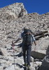
Got to the parking area (just off SR 88) just before 6am. Temps were a little chilly (in the 50's), but that was ideal for a hike like this. Hopefully this would minimize the activity of some the cold blooded critters out there. Took a user trail to connect to Jacob's Crosscut which I took over to Siphon Draw. Surprised at the minimal activity. Only saw two hikers on the way up to the Draw. Took me about an hour to get to the turn off. Decent time. Things slowed down considerably thereafter. The drainage was a patchwork of heavy growth and moderate to light growth with rock slabs and boulders providing isolated islands of space to regroup and plan your next 10 feet. for most of the climb I was hugging one wall or the other do the growth in the bottom. About halfway up the drainage split. One went to the north the other south. There had been cairns leaning more to the south drainage so after some deliberation I kept to the south channel. (Both drainages looked doable and the north drainage would provide a more direct route to the goal). The south drainage ended up being a solid choice. A little clogged initially, but the higher up I got the more it opened up. Actually made it to the ridge faster than I realized.

Reaching the intermediate "crown" was pretty sweet. Not only were the views awesome to the east and west, the openness was a nice change from the foliage fubar on the climb up. Taking in the views I noticed that looking down to the east that I could see the upper end of the "Canyon of the Waterfalls." This was part of a hike I did a few weeks ago and got the wheels turning for an audible for this hike. By coming up the south drainage, I found that I "cliffed out" on the "crown". On the north side of the crown there was decent drop off. This caused me to back track a little and descend down the eastern side and trek along the base of the crown. After that it was smooth hiking on my way to peak 4102. There was some ups and downs along the way, but the ridge was very open so I was easily able to choose my rate of ascent/descent. Some very cool rock formations at 4102 and the views were stellar. Sat down and enjoyed the views and the weather. The solitude was great, though surprisingly, I could occasionally hear voices from the Flatiron.

From 4102 I started to walk the perimeter with the idea of trying to connect to the trails to the north (Praying Hands and Canyon of Waterfall trails). As I was doing this I was shocked to see a platform extending into space. It was to the north and below 4102 but I could imagine what it would be like to be on that plank and felt my heart racing just thinking about it. I wanted to check it out, but I descended on the east side and access from that side wasn't as direct as I thought it would be. (Getting to it from the south and west side is the way to go). I tried climbing one of a couple of rock buttes to get a picture but I wasn't able to see it from the east side. I did, however, get a jaw dropping look straight down :o I was on one of the cliffs looking down on Praying Hands. Very cool...from a respectable distance. I enjoyed walking among the rocks, taking in the views as I began to work my way back south. Looking for routes descending to the east side, there were no obvious paths going down, but as I approached the crown the slope leading down to Canyon of Waterfalls called to me. Honestly, the descent down the east slope didn't look any worse than what I came up on the west side. With that in mind, I decided to give it a try. It actually worked out well. It was actually much more open, with less foliage making for multiple route options. I was surprised to find, as I neared the canyon to find water still flowing. This was an added bonus. I love the sound of flowing water. But it also made things slightly more complicated as it forced me out of the wash and up onto to the shoulders of the wash. Despite this challenge I was still able to connect to the Waterfall trail.

Up until this point the hike had just been me and the mountain. This quickly changed as I got on the Praying Hands trail. I encountered well over a dozen people, even before hitting the Treasure Loop trail. Even saw a group of people scaling one of the rock monoliths just north of the praying hands. It was cool looking up and literally seeing where I was a couple of hours ago. Also, noticed the platform extending into nothingness. Obvious, now that I knew to look for it. Had to deal with the masses as I descended down Treasure Loop, but I got off as quickly as I could taking a user trail that connects to Jacob's Crosscut. On this briefly, before taking another user trail back to where I parked.

Great hike! Happy that I didn't see any "cold critters", but disappointed that I didn't see much else. Rabbits and quail on the bottom, chipmunks on top and lizards everywhere. Temps were great again.
_____________________
  2 archives
Feb 01 2023
avatar

 Guides 59
 Routes 1,100
 Photos 1,191
 Triplogs 1,290

male
 Joined Jan 01 2023
 Arizona
Peak 4102 - SuperstitionsPhoenix, AZ
Phoenix, AZ
Hiking avatar Feb 01 2023
pseudalpineTriplogs 1,290
Hiking8.23 Miles 4,045 AEG
Hiking8.23 Miles   6 Hrs   52 Mns   1.58 mph
4,045 ft AEG   1 Hour   39 Mns Break
 
1st trip
Route Scout Route Recorded  on Route Scout | Pop | Map | Popup | MapDEX
Instead of the Official Route to Peak 4102, we turned left off of Siphon Draw near Siphon Dome (The Gatekeeper) and ascended the Ripped Shirt or BASE jumpers gully. The route manifests with a few cl.3 ledge scrambles before reaching the Lost Dihedrals hanging valley north of The Three Old Maids. We didn't remember the previous route we'd taken in the past and wandered around within some mildly annoying vegetation, eventually finding a passable gully and topping out on the plateau near the yellow-hued peak. After a short summit break, we hiked southeast, then up, merging into the upper part of the Reverse Flatiron route. There were a few neat areas of verglas on the way to Ironview Peak. After another summit and our first beer, the hiking was considerably easier down to the Flatiron (another beer) and eventually out via Siphon Draw, the Palmer Mine bypass and the east side of the Treasure Loop.
 Named place
 Named place [ checklist ]
[ checklist ]  Superstition Peak 5024
  10 archives
Jan 19 2020
avatar

 Routes 7
 Photos 1,242
 Triplogs 61

57 female
 Joined Nov 21 2015
 Phoenix
Peak 4102 - SuperstitionsPhoenix, AZ
Phoenix, AZ
Hiking avatar Jan 19 2020
PicklesTriplogs 61
Hiking7.20 Miles 3,179 AEG
Hiking7.20 Miles
3,179 ft AEG
 
1st trip
Linked   none no linked trail guides
Partners none no partners
I underestimated the little punch that comes with this hike. It leaves Syphon Draw, goes into a ravine, leaves the ravine and climbs steeply through loose scree and nature things that like to poke and stab. I started by following the route I had uploaded, followed by a few cairns here and there. However, I found it more to my liking to find my own path of least resistance. Not that it was better, but seemed more practical to me.
Getting through the ravine was difficult but less abusive than that freakin climb out of it! Who put that hill with all those land mines there???
No bees this time, I'm glad I got it done!
_____________________
 
Apr 21 2019
avatar

 Routes 7
 Photos 1,242
 Triplogs 61

57 female
 Joined Nov 21 2015
 Phoenix
Superstition Mountain - Near Peak 4175, AZ 
Superstition Mountain - Near Peak 4175, AZ
 
Hiking avatar Apr 21 2019
PicklesTriplogs 61
Hiking
Hiking
 no routes
1st trip
Partners none no partners
The hiking destination was to be Peak 4175 and Peak 4102. One must venture up a ravine to the left of the much traveled path up to Flat Iron at the top of Syphon Draw. Initially, the route is pretty simple to follow and there are a few cairns in the much overgrown ravine that needs to be navigated. I made it about half way up and could clearly see the trek was going to be a bit more challenging than anticipated but I was prepared for it and didn't mind that part of it. However, little creatures that sting mercilessly and like to instill fear in anyone who might be in their vicinity will always turn me back on a hike quicker than anything! I came to a certain choke area I really needed to go through but an area that was really really guarded and inhabited by enough bees to cause me great pain! This would be the end of my pursuit of 4175 and 4102 for the day. I WILL RETURN TO COMPLETE THE TASK!
I refused to call it a day on the whole hike though. I made my way back down Syphon Draw but ventured off trail and climbed up a very steep hillside and into another ravine to see what I could see! Found a lot of bighorn droppings, coyote poo and a mass amount of feathers from some unfortunate winged creature who apparently met an unpleasant demise. What I also picked up on are other areas all around that mountain just begging to be explored. The climb to these areas will certainly be steep but do-able. The hoodoos back in those places would be fascinating up close and personal.
Turned out to be quite the nice solo hike!
_____________________
 
Dec 03 2018
avatar

 Guides 7
 Routes 187
 Photos 2,318
 Triplogs 909

74 male
 Joined Dec 10 2016
 Gold Canyon
Peak 4102 Loop, AZ 
Peak 4102 Loop, AZ
 
Hiking avatar Dec 03 2018
DaytripperTriplogs 909
Hiking9.54 Miles 2,933 AEG
Hiking9.54 Miles   7 Hrs   5 Mns   1.64 mph
2,933 ft AEG   1 Hour   15 Mns Break13 LBS Pack
 
1st trip
Linked   linked  
Partners none no partners
Started the day at a cool 44 degrees from Lost Dutchman State Park, headed up Treasure Loop and turned onto Crosscut Trail, instead of initially going to Praying Hands. After reaching Crosscut Trailhead meandered up to the rock formations between Praying Hands and Massacre Grounds crossing the use route between them. This mostly off trail hike was fun except a couple of portions. Continued upward taking the route traversing a dry waterfall ,after passing by a cairned reverse flat iron route ,on the other side of the drainage, elected to stay up high negotiating rock formations, cactus ,catclaw and other unsavory characters. Made a reasonable guess as to the location of 4102 as I ended up reaching the ridgeline a little south of 4175. Easy walking from there to 4102 ,can use line of sight but watch for ankle biting cactus, retraced the same ridgeline route except circumventing 4175 down to the saddle , travel down to Siphon Draw from there was not fun. Steep with abundant scree , prickly vegetation , even the drainage above the Siphon Draw waterfall had thriving catclaw,will need to wait until I forget about this part before doing it again. Once getting to Siphon Draw was able to pick up the pace back to the parking lot.No wildlife to report, saw one other hiker on the rock formations below 4102, then several on Siphon Draw trail.As Steph and Blake noted the different perspective of this areas landmarks made the destination worthwhile.

dry Siphon Draw Waterfall Dry Dry
Small pool at base and in drainage above
_____________________
Navy31 Army13
 
Oct 08 2017
avatar

 Guides 2
 Routes 267
 Photos 9,816
 Triplogs 402

62 male
 Joined Dec 02 2014
 Mesa, AZ
Peak 4102 - SuperstitionsPhoenix, AZ
Phoenix, AZ
Hiking avatar Oct 08 2017
adillingTriplogs 402
Hiking7.00 Miles 2,500 AEG
Hiking7.00 Miles
2,500 ft AEG
 
1st trip
Linked   none no linked trail guides
Partners none no partners
I exchanged a few messages with Steph_and_Blake about this hike. I have never been up to this part of the mountain. It turned out to be an excellent adventure for sure.

I loaded the track from HAZ and headed of the Siphon Draw Trailhead at Lost Dutchman SP. The trail basically starts at near the top of the Siphon Draw trail. Take a left and then it’s a matter of following the drainage up to the small saddle and then hanging another left to reach the first peak, 4175.

The hike up was steep, but not as bad as the next door neighbor, the chute going to the Flatiron. There are a few rock scrambles and there is a bunch of catclaw and cacti all the way up. There is a bit of loose scree in a few sections. The trail is not really a trail. There are cairns in place along the way to help out. I just kept going up when the trail was not clear.

Once I made it to the saddle, it is very easy to navigate the trail. It’s a bit of an elevation gain to the first peak, 4175. You get some excellent views of the Flatiron, 5024, Four Peaks, AJ and the Goldfield. You can see 4102 across the mesa. You also get views of the cliffs of the mountain as well.

I headed over to 4102. The views up there were nice as well. I could not resist heading out to a few of the cliffs. There appears to be some sort of platform at the end of one of them. I have seen base jumpers leap off from there. It must be up there for them? I could only go out so far on some of them.

It was awesome finally getting up to the top of this part of the mountain. I will head back up there when it cools down a little. Today got a little toasty!

Thanks for the suggestion Steph_and_Blake!
_____________________
"Jobs fill your pockets, adventures fill your soul."

instagram: @andydilling
 
Mar 26 2017
avatar

 Guides 6
 Routes 23
 Photos 1,125
 Triplogs 593

46 male
 Joined May 23 2012
 Mesa, AZ
Peak 4102 - SuperstitionsPhoenix, AZ
Phoenix, AZ
Hiking avatar Mar 26 2017
syoungTriplogs 593
Hiking7.38 Miles 2,749 AEG
Hiking7.38 Miles   2 Hrs   36 Mns   2.84 mph
2,749 ft AEG
 no routes
1st trip
Partners none no partners
Tagged the Gatekeeper on the way up and down. I have been meaning to tag these two for a little while now. I have been horribly sick (as sick as I was in Africa a few years prior) this past week. Some sort of URI and I knew that I wouldn't be able to go fast. I wanted to go out into the Superstitions, however, so off trail would force me to go slow.

The slog up the drainage from the saddle is not fun right now. It is very overgrown. The views of Flatiron and the surroundings are pretty incredible though.
_____________________
  2 archives
Feb 14 2017
avatar

 Guides 100
 Routes 63
 Photos 2,548
 Triplogs 184

76 male
 Joined Nov 21 2015
 Grand Junction,
Peak 4102 - SuperstitionsPhoenix, AZ
Phoenix, AZ
Hiking avatar Feb 14 2017
Steph_and_BlakeTriplogs 184
Hiking7.00 Miles 2,500 AEG
Hiking7.00 Miles
2,500 ft AEG
 
1st trip
Linked   none no linked trail guides
Partners none no partners
See Hike Description.
_____________________
Stephanie and Blake Barnard
 
average hiking speed 1.81 mph

WARNING! Hiking and outdoor related sports can be dangerous. Be responsible and prepare for the trip. Study the area you are entering and plan accordingly. Dress for the current and unexpected weather changes. Take plenty of water. Never go alone. Make an itinerary with your plan(s), route(s), destination(s) and expected return time. Give your itinerary to trusted family and/or friends.

helpcommentissue

end of page marker