|
| | | |
| |
|
| Hiking | 2.24 Miles |
745 AEG |
| | Hiking | 2.24 Miles | 1 Hour 51 Mns | | 1.21 mph |
| 745 ft AEG | | | | |
|
|
| |
| Linked |
|
none
[ show ]
| no linked trail guides |
| Partners |
|
none
[ show ]
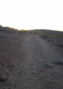
| no partners | | After my last two hikes I was ready for a nice short trail. This worked perfectly. I parked down the road, so I had to do some road walking to get to the trail. I started around 6:30am. The enclosed canyon was still dark so I had to use my Garmin light for the first 20 minutes. The trail takes off directly across from the natural spring. The trail is a nice single track that starts off with a couple of switchbacks before aggressively going up the spine of the mountain. Pretty cool section with some brief exposure. You can see the general area where the falls would be, but it was quiet today. No water, not a huge surprise with our lack of moisture this winter. The trail alternates between lazy switchbacks and stair climbs. There was an odd fence rail about halfway up. It was one of the more mild slopes, I can’t imagine its purpose. Seemed flimsy. I wouldn’t de surprised if it was toppled in 10 years. The trail summits cutting through some large rocks at the top. Views are minimal at that point, but if you walk south along the rim you get some nice expansive views. I followed a faint, cairned trail for a bit, waiting for sunrise, then took a few pics and headed down. Instead of following the road, I went down to the creek and followed that up river. There was a trail at first, but it soon became a bushwhack.
Neat trail. The canyon is mute before sunrise, but really comes alive under the sunlight. Weather was great; clear skies, cool temps (40’s) and no breeze. No wildlife, and no other hikers. The natural spring across the road was like a QT station with people lining up to fill their jugs. As I was hiking down I watched one person fill up four 5 gallon jugs. |
| _____________________
| | |
|
|
|
 Route Editor