|
| | | |
| |
|
| Hiking | 5.00 Miles |
2,572 AEG |
| | Hiking | 5.00 Miles | 3 Hrs | | 1.67 mph |
| 2,572 ft AEG | | | | |
|
|
| |
| Linked |
|
none
[ show ]
| no linked trail guides |
| Partners |
|
none
[ show ]
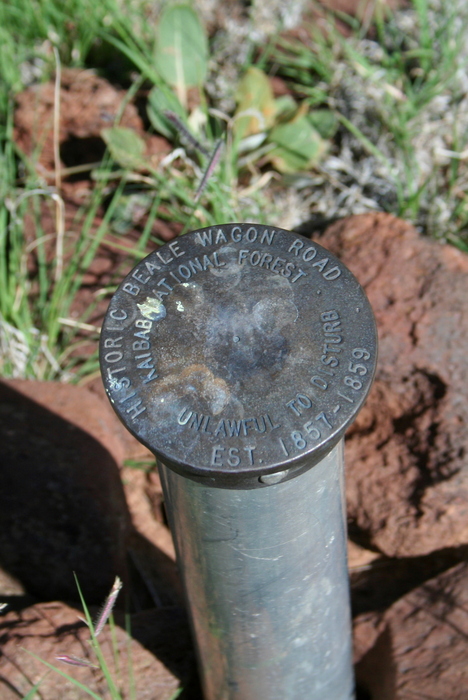
| no partners | | Government Prairie sections of Beale Wagon Road
Up in Flagstaff for an Arizona Bioindustry Association board meeting with some hiking with Lynn and Skippy on the agenda. I'm a board member of the Arizona Bioindustry Association (check out www.azbio.org ) and with our quarterly board meeting scheduled for Flagstaff on Friday 7/29, decided to make it an "over-nighter" to get out of the valley heat and check out some trails.
Booked into the "dog-friendly" Marriott Springhill Suites a couple of weeks in advance (good call as every hotel was SOLD OUT due to Cardinals training camp) and also took advantage of their members' early check-in policy. After a quick stop at Buffalo Park, Lynn and Skippy dropped me off at NACET (check out www.nacet.org ), Flagstaff's hi-tech incubator, who were hosting our board meeting.
After the board meeting, hitched a ride to the "BEER and BIO" (http://beerandbio07292011na.eventbrite.com/ ) meet and greet event hosted at the Tinderbox Kitchen (check out www.tinderboxkitchen.com ) on San Francisco St. just south of the railway tracks.
With board duties completed, caught up with Lynn and Skippy on one of the Flagstaff Urban Trails as we checked out many of the local establishments for some evening munchies. When we got back to the hotel, one of the Phoenix TV stations was in the middle of a live broadcast of Cardinal's training camp activity next to our parked vehicle. The crew was appreciative we didn't disrupt their live broadcast - waiting until they were done before accessing our vehicle. Skippy also seemed to make instant friends with the crew.
Saturday had Government Prairie penciled in for our hiking destination. Threatening skies and the sound of rumbling thunder didn't deter our hiking as we explored Rain Tank Hill and hiked along a double-track towards Government Knolls. We met a couple of mountain bikers along the double-track. One of them had an ultra-cool GPS with built-in weather radar (internet connection I suspect). They indicated a storm was coming down from the north behind Kendrick Peak and was tracking towards us in the next 15-20 minutes. Sure enough, Kendrick Peak began to disappear enveloped in storm clouds. I could see a wall of rain heading towards us, so time to head back to Lynn's mini-van. A torrential rain plus totally soaked us before we made it back to the vehicle. When I started up the van and cranked up the heat, noticed the outside temperature was 59degF. Temperature was 114degF when we got back to the valley around dinner time on Saturday. A +50degF temperature swing in about 3 hours - how about that! |
| _____________________
| | |
|
|
|
 Route Editor


