|
| | | |
| |
|
| Hiking | 14.70 Miles |
2,350 AEG |
| | Hiking | 14.70 Miles | 6 Hrs | | 2.45 mph |
| 2,350 ft AEG | | | | |
|
|
| |
| Linked |
|
none
[ show ]
| no linked trail guides |
| Partners |
|
none
[ show ]
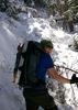
| no partners | | Interesting hike, definitely not expected in the Superstitions. We planned it as an overnight backpack, but definitely forgot a few of the necessities (not to mention mileage is closer to 15 round-trip). After we left the trailhead, realized neither one of us had spoon/fork for our freeze dried dinner...good thing we each had a compass.
Easy 3 hours in, got a little annoying having to cross the streams so many times (at least I finally had a chance to put the gor-tex boots to good use). Setup camp, got a fire going, had dinner, went to bed. Overnight temperatures dropped quite a bit. I was win an OR Alpine Bivy w/ REI 20° bag and was cold throughout the night (t-shirt + Patagonia R1 hoody on top, thermals on bottom).
After a solid 3-hours sleep while trying to stay warm, "woke" up and packed everything up. Hike out took the same amount of time. The hardest part was probably the last mile or so coming back to the trailhead, I knew there was a bit of uphill but wasn't fully prepared.
Good trip, very few people. Did find it odd that there was an empty tent near the ranch foundation, as well as some other fully stocked campsites (canned food, water, etc). I assume some hunters setup camp there and just left it (worst case we figured there was a body in the tent...wasn't brave enough to find out).
If you're going to camp, make sure you plan for freezing temps in the evening. Firewood was kind of hard to come by, anything sitting on the ground was wet and required a decent fire before throwing on. Water from the creek was good, we ran it through a filter to be on the safe side, but glad to report no ill-effects. |
| _____________________
| | |
|
|
|
 Route Editor