|
| | | Upper Wolf Creek Canyon, CO | | | |
|
|
Upper Wolf Creek Canyon, CO
| | |
| |
|
| Canyoneering | 1.50 Miles |
|
| | Canyoneering | 1.50 Miles | | | |
| | | |
| | Intermediate Canyoneering - Difficult or dangerous; Tech Climb; rope reqd; descent anchor; exit technical; | | C - Strong current; wading/swimming; waterfalls; possible wet/dry suit | | Risky - Extraordinary risk factors exist; solid skills/judgement reqd; no beginners | | III - Normally requires most of a day |
| |
| Linked |
|
none
[ show ]
| no linked trail guides |
| Partners |
|
none
[ show ]
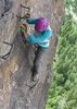
| no partners | | Wolf Creek, one of the best canyons in Colorado with a very short seasonal window of opportunity to descend. The beta had me a little freaked out through, with an R rating and class C water, along with warnings of it being "extremely dangerous" depending on the flow. As usual, my pre-canyon jitters were for nothing as it turned out to be an INCREDIBLE day in a beautiful wooded canyon full of amazing waterfalls. That being said, the warnings about the danger are accurate especially if the water is high and the group unfamiliar with class C techniques.
Most rappels were out of the direct flow, which I was pretty happy for. As gorgeous and fun as waterfalls are, they can be pretty intense to rappel through especially when your face is getting blasted by water (difficult to breathe, can't see much, water forces you down the rope, etc). We did set up one rope directly in the water, which was pretty fun despite the fact that it resulted in a cracked rib for one of us. 
Beta note: The current KML track on ropewiki is inaccurate and indicates incorrect approach/exit waypoints. The exit is also noted to be one of the worst of all canyons which is pretty far off too. It's basically 500 feet of barely class 3-ish terrain up to the highway, similar to any WCC exit.
We bailed on Lower Wolf Creek due to storm building up on the horizon. All in all, an amazing day with wonderful people in a beautiful place! 
|
| _____________________
| | |
|
|
|
 Route Editor