|
| | | |
| |
|
| Hiking | 7.00 Miles |
3,170 AEG |
| | Hiking | 7.00 Miles | 3 Hrs 25 Mns | | 2.21 mph |
| 3,170 ft AEG | 15 Mns Break | | | |
|
|
| |
| Linked |
|
none
[ show ]
| no linked trail guides |
| Partners |
|
none
[ show ]
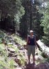
| no partners | | My boyfriend and I did this Sunday afternoon hike and have no idea how far we went. We got kind of confused with the directions from the hike description and the description I had from an old Phoenix mag. Eventually we found the parking area which came up pretty quickly on the left after the road turned to dirt and took to the trail. The ground seemed slightly damp as we ascended and became quite a slog since the trail was significantly eroded approaching Dog House Spring. I'm not even sure how far along the trail we made it since I judged our path according to one of the GPS routes which seemed to show a peak around mi 2.4. We never made it to any peak, but did pass through three gates (two marked with a request to close it and one unmarked) and an interesting ecosystem of pines, oaks, prickly pear cacti and cholla. Good hike all around- especially the well deserved dinner at Los Hermanos in Superior  |
|
Autumn Foliage Observation Light
|
|
| _____________________
| | |
|
|
|
 Route Editor


 . I scraped the hell out of my elbow, knee and ankle, but managed to clean up adequately and make it to Four Peaks for Pumpkin Porter without further incident. Only drawback is that now no one wants to let me hike solo.
](https://hikearizona.com/dex2/images/smilies/eusa_wall.gif "Brick wall") I definitely want to bring the BF for a hiking/boating afternoon under the pines.
I definitely want to bring the BF for a hiking/boating afternoon under the pines.


