|
| | | |
| |
|
| Hiking | 7.70 Miles |
2,616 AEG |
| | Hiking | 7.70 Miles | 8 Hrs | | 0.96 mph |
| 2,616 ft AEG | | 25 LBS Pack | | |
|
|
| |
| Linked |
|
none
[ show ]
| no linked trail guides |
| Partners |
|
none
[ show ]
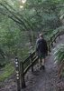
| no partners | | Cave of the Domes is a serious of domed rooms connected by chutes and tunnels beneath horseshoe mesa. The Grandview trail is fairly rough in places, but one of my favorite trails in the Grand Canyon. (It was carved and built in the 1890's what do you expect?  ) )
At 3 1/2 miles down youll reach the campgrounds where I stopped to pitch a tent and have a snack. After lightening my pack, I headed around the left side of Horseshoe Mesa. The left side of the horseshoe will point to a shallow wash which almost immediately turns into a trail. Follow this trail off of the side of the butte, to reach the cave entrance. Dont take the first entrance, its too small and littered with droppings. Take the second entrance and crawl under to enter the first dome. There youll find a trail-log and string, along with knee-protecting cardboard cutouts. Be safe... mark your route if you dont know this area and bring at least 3 light sources. I read about a kid who came in with one flashlight which he ended up breaking and he was stuck here for 3 days until NPS came down and got him out.
Ive been in this cave-system twice and have managed to explore every room that can be accessed without climbing gear. Sadly, there is light graffiti and damage, as its the only cave system in the grand canyon that can be accessed without a permit. Be safe, and carry at least 3 light sources.
After exploring the cave, I headed back to camp and then down to Page spring which is the only water source in this area. This spring carries traces of arsenic, but is assumed to be safe for limited use. Hey! Here are some pics for ya!!
https://www.facebook.com/media/set/?set=a.3306249940001.2133123.1380622073&type=3&l=f011419d6f |
| _____________________
| | |
|
|
|
 Route Editor