|
| | | |
| |
|
| Hiking | 1.00 Miles |
470 AEG |
| | Hiking | 1.00 Miles | | | |
| 470 ft AEG | | | | |
|
|
| |
| Linked |
|
none
[ show ]
| no linked trail guides |
| Partners |
|
none
[ show ]
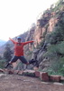
| no partners | | This hike was a bust and a waste of a $20 permit. We followed the directions on this site and a few others, but we had to be in the wrong area. We parked in the pullout/lookout area 3 miles from the bridge. There was a kind-of/maybe trail in the distance but it didn't look all that accessible so we went to see the lookout just before the 3-mile one and the one right after the 3-mile one. Those were pretty much sheer cliffs so they definitely weren't the right place.
We went back to the 3-mile lookout, parked, and made our way very clumsily down hill. There may have been a fall or two. We got to the kind-of/maybe trail and followed it til it disappeared. We were no closer to the river and could see no way down. We bushwhacked a bit and after causing a few mini rock/dirt slides, we realized that this was too dangerous to continue. We then couldn't find the kind-of/maybe trail to go back so we just headed in the right direction and hoped for the best. There may have been a few more falls, cuts, scrapes, and contusions along the way as we tried to make it back up the steep slope. We finally decided the best idea would be to head straight up, climbing rocks, to the highway and walk along it back to the car.
We had a really fun time trying to get somewhere, but in the end we got nowhere and did not see Sawmill Canyon. Most expensive mile I've ever hiked. However, if I priced it out by cuts and bruises, I definitely got my money's worth. |
| _____________________
| | |
|
|
|
 Route Editor