Route Editor

| Guide | ♦ | 8 Triplogs | 0 Topics |
details | drive | permit | forecast | route |
stats |
photos | triplogs | topics | location |
| 28 | 8 | 0 |
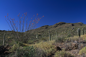
Desert Wandering by fricknaley  The Tucson mountain foothills north of Wasson Peak offer a lot of nice trails and nameless beautiful desert peaks that can be combined in all sorts of ways for various distances and difficulties. One of the nameless peaks I've been eyeballing is Peak 3037, which sits just north of a nice saddle connecting Thunderbird Trail with the Brittlebush Trail in Saguaro West National Park. The peak is a short desert bushwhack from the saddle. Can't miss stuff. The Tucson mountain foothills north of Wasson Peak offer a lot of nice trails and nameless beautiful desert peaks that can be combined in all sorts of ways for various distances and difficulties. One of the nameless peaks I've been eyeballing is Peak 3037, which sits just north of a nice saddle connecting Thunderbird Trail with the Brittlebush Trail in Saguaro West National Park. The peak is a short desert bushwhack from the saddle. Can't miss stuff.From the ubiquitous Ringtail trailhead just west of Contzen Pass, head across Picture Rocks road and cross through the gate into the wash. Hike the broad wash, which pretty quickly narrows down. In 0.13 miles the signed Camboh Trail breaks off right. Stay on the ringtail. It quickly narrows down to a path and leaves the wash. In 0.45 miles from the trailhead, the Muledeer Trail breaks off right, hang left, and stay on the Ringtail. This trail skirts around the west side of Picture Rocks with nice views and rambles through the desert on its way to Picture Rocks Wash. There is perfect desert vegetation along the way.
Mark your spot and eye Peak 3037 due north. There is no trail. Just leave the saddle and head straight up. It's only 0.2 miles to the top, about 300 feet straight up. You can see the false summit to the left (west) so just make sure to keep right of it. There is a lot of cholla and loose rock on the way up so please be careful. The top provides excellent 360 views of Tucson, Saguaro National Park, and the Catalinas. Be careful on the way down and just pick your way back to the saddle. Back at the saddle continue west on the Brittlebush Trail. It soon dumps you in Brittlebush Wash and heads north. This is a more narrow wash, with nice vegetation and color. Smooth sailing here for about 0.9 miles where you'll see a sign at the junction with Picture Rocks Wash coming in from the left. Almost immediately after is the signed take-off out of the wash for Ironwood Forest Trail. Take this out of the wash and ramble north and east through perfect desert and heavy saguaro stands for 1.2 miles to the Muledeer Trail. Hang a right onto the Muledeer and cut east for 0.3 miles back to the signed intersection with the Ringtail Trail. Take a right and hike about 0.45 miles back to your car to complete this roughly 6.85-mile peak-bagging loop. Gate Policy: If a gate is closed upon arrival, leave it closed after you go through. If it is open, leave it open. Leaving a closed gate open may put cattle in danger. Closing an open gate may cut them off from water. Please be respectful, leave gates as found. The exception is signage on the gate directing you otherwise.
Check out the Official Route and Triplogs. Leave No Trace and +Add a Triplog after your hike to support this local community. | |||||||||||||||||||||||||||||||||||||||||||||||||||||||||||||||||||||||||||||||||||||