 Route Editor

| Guide | ♦ | 49 Triplogs | 0 Topics |
details | drive | permit | forecast | 🔥 route |
stats |
photos | triplogs | topics | location |
| 148 | 49 | 0 |
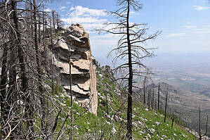
Once a fine forest by HAZ_Hikebot  Because of the notable views it offers, Arcadia Trail has been designated a National Recreation Trail, placing it among the most outstanding trails in the nation. Most people travel this popular pathway from Shannon Campground to Arcadia because it's mostly downhill in that direction. The course it follows winds in and out of stands of trees that are made up mostly of Douglas-fir, Engelmann spruce, and quaking aspen on the upper end while changing gradually to ponderosa pine and silverleaf oak on more southern-facing slopes as the trail nears Arcadia Campground. Because of the notable views it offers, Arcadia Trail has been designated a National Recreation Trail, placing it among the most outstanding trails in the nation. Most people travel this popular pathway from Shannon Campground to Arcadia because it's mostly downhill in that direction. The course it follows winds in and out of stands of trees that are made up mostly of Douglas-fir, Engelmann spruce, and quaking aspen on the upper end while changing gradually to ponderosa pine and silverleaf oak on more southern-facing slopes as the trail nears Arcadia Campground.Near the upper trailhead, there is an area that has been logged and remains relatively open where you may find some tasty wild raspberries if you come in late summer. Beyond a series of switchbacks at about a mile from the trailhead, Heliograph Trail #328A climbs to the top of Heliograph Peak where the rugged landscape of southeastern Arizona forms a sweeping, unbroken panorama. Many who use this trail take this spur and follow the Heliograph Road back to Shannon Camp for a loop of about 4 miles.
Note: Heliograph Peak Trail #328A and Noon Creek Ridge Trail #318 branch off the Arcadia Trail. Hikes to consider: - 3.2mi / 1024ft Heliograph Peak via Shannon GC - 10mi / 3322ft Heliograph Peak via Arcadia CG - 4.25mi / 1030ft Heliograph Peak Loop - 8.5mi / 2550ft Noon Creek Ridge Trail #318
Check out the Official Route and Triplogs. Note This is a moderately difficult hike. Leave No Trace and +Add a Triplog after your hike to support this local community. One-Way Notice This hike is listed as One-Way. When hiking several trails on a single "hike", log it with a generic name that describes the hike. Then link the trails traveled, check out the example. | ||||||||||||||||||||||||||||||||||||||||||||||||||||||||||||||||||||||||||||||||||||||||||||||||||||||||||||||||||||||||||||||||||||||||||||||||||||||||||||||||||||||||||||||||||||||||||||||||||||||||||||


