Route Editor

| Guide | ♦ | 9 Triplogs | 0 Topics |
details | drive | permit | forecast | 🔥 route |
stats |
photos | triplogs | topics | location |
| 234 | 9 | 0 |
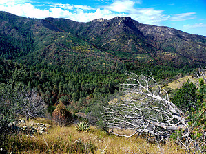
Everchanging Environment by tibber  These trails traverse a wide range of biologic zones. Mormon Canyon Trail #352 passes through a picturesque riparian area that includes several Rocky Mountain Maples. This loop provides plant life found in the Upper Sonoran Desert, such as Schott's Yucca and Silverleaf Oak. The trails climb into a forest of Engelmann Spruce, a species found as far north as British Columbia. These trails traverse a wide range of biologic zones. Mormon Canyon Trail #352 passes through a picturesque riparian area that includes several Rocky Mountain Maples. This loop provides plant life found in the Upper Sonoran Desert, such as Schott's Yucca and Silverleaf Oak. The trails climb into a forest of Engelmann Spruce, a species found as far north as British Columbia.Starting from the Mormon Ridge Trailhead on the west side of the Chiricahua Mountains, this is a rugged loop that ascends the Mormon Canyon Trail #352 (3 miles) and returns via Mormon Ridge Trail #269 (4 miles), or you can reverse it (both ways are steep). From the junction of the two trails at the top of the canyon (Mormon Saddle), you can head up to the Crest Trail #270, and from there, so MANY options.
After you cross W Turkey Creek from the road, you will eventually be following an old road thru large oaks and junipers. Enjoy the road while you can as soon the trail changes due to the blowouts from the erosion caused by water coming down the mountain. As you make your way up the Canyon, you will not be too far from the drainage that runs into the Creek. This Canyon has a bit of a spooky aura to it, especially on a cloudy day. You will eventually come upon the Chiricahua Wilderness Marker (if it's standing). Along the trail to your left, you may be able to spot an old rectangular cement trough, the remnants of an old sawmill with scattered brick around it, and the Mormon Spring (Latitude: 31.8564814 Longitude: -109.322007) Box. So if you have a moment, explore around a little; it's lots of fun. Continuing up, you may be able to spot the Spring Rock and Tree on your right. Eventually, you will cross over the drainage to the other side of the canyon and then continue the incline up the extremely picturesque canyon. You will see occasional mossy sections as well as some cascades of water. Eventually, the water will disappear, as will the trail. It is cairned in spots, but not so much on the upper reaches. About 1/2 way up, you will see a small amount of burned pines (pre-Rattlesnake Fire). From here, the trail will switchback once in a while, but it is in this section that you might have to feel your way around. Your goal, of course, is to get to the crest. To your left is the clear area below the trees. You don't want to go further than that and instead want to keep a steady course up the grassier part of the canyon. I would suggest if you don't have pretty good route-finding skills, you may want to think twice about hiking this trail. A route is loaded, but it's not perfect due to the disappearing trail and getting around obstacles. (I don't think you can get too lost as you know you must go up). Three miles later, you are at the saddle. You can head south (right) on the Mormon Ridge Trail for 0.7 miles to reach the Crest Trail, which connects you to many areas in the tops of the Chiricahuas. For this loop hike on the Mormon Ridge Trail, turn left at the sign. You will pass the trail you came upon, so be careful as the two trails run parallel for a few minutes, so you need to stay on the higher trail, or you will be heading back down the canyon. You will now be heading west along the ridgeline above the Canyon you just came up. This part of the hike is primarily out of the shade, so keep that in mind. You will switch back from time to time but mostly stay on the side (south) that keeps the Canyon in view. From one section, you can see the Whetstone and the Pinaleno mountains. As you eventually come across and are looking west, you will get to see the Dragoons. At one time, you will go around on the north side as you cross behind away from the Canyon. You will continue your way mostly down the south side of the ridge, passing thru some of the new and old burn areas. You will also encounter some tricky switchbacks, so please pay attention to the tell-tale signs such as rocks or logs across an area where you need to turn. You will cross back and forth over a scree chute a few times, but nothing too ominous. Other than that, it's pretty easy to follow the trail though it doesn't appear to be used much. The views are well worth it. Four miles later, you are back at W Turkey Creek and the road. This trail is called Mormon Ridge Trail #269. Check out the Official Route and Triplogs. Leave No Trace and +Add a Triplog after your hike to support this local community. | ||||||||||||||||||||||||||||||||||||||||||||||||||||||||||||||||||||||||||||||||||||||||||||||||||||||||||||||||||||||||||||||||||||||||||||||||||||||||||||||||||||||||||||||||||||||||||||||||||||||||||||||