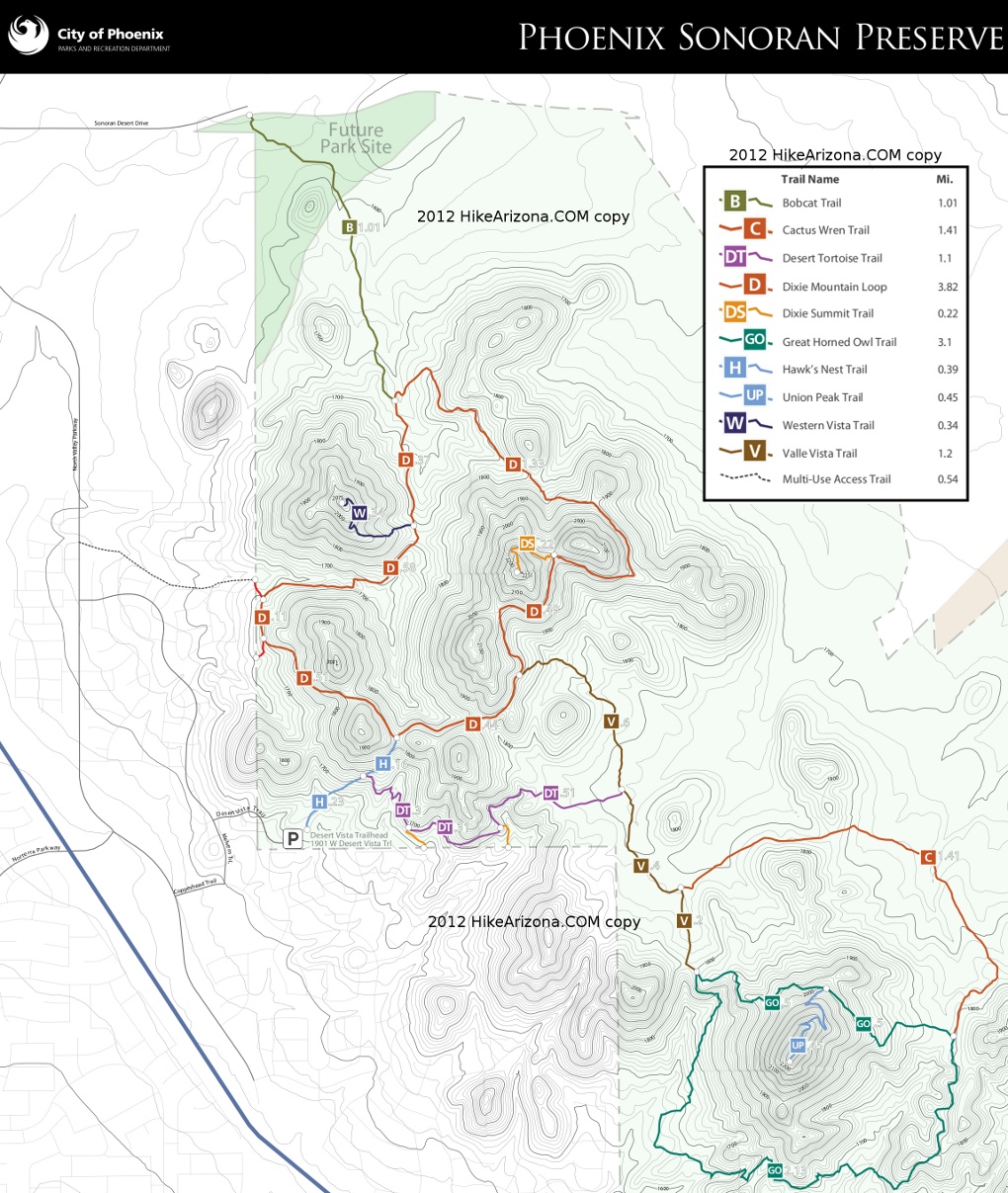
Western Vista Trail is accessed on the west side of Dixie Mountain Loop in the valley of the NW area of Union Hills.
The grade on this 0.7-mi out-n-back peak might be considered steep vs the mild avg 2.8% grade around Dixie Mountain Loop. The footing is pretty good, perhaps a touch loose. The grade is not vicious at 13.5%. That's a third less vs Piestewa/Camelback and no knee-to-waistline steps.
A Yellow Paloverde semi-canopying the trail is fantastic about an hour after sunrise. Halfway up a small line of basalt is surfacing. Better than expected views across I-17 to Deem Hills Recreation Area, Pyramid Peak and back across the Sonoran Preserves. The Bradshaw Mountains are subtle to the northwest but the edge of the New River Mesa and Black Mesa catch the low angle light of sunrise/sunset.
Every rose has its thorn. There is a distance/subtle urban hum but the Madison Granite landscape rock/gravel pit is the commanding thorn directly below to the west-northwest.
Access trails are popular with mountain bikers and hikers with dogs. On a Tuesday, November morning I first hiked this trail the area had a strong friendly neighborhood vibe.
Out-n-Back Stats
Direct from Desert Vista Trailhead: 4.15-mi / 925 AEG
Sonoran Desert Dr via Bobcat Trail: 3.75-mi / 555 AEG
When hiking several trails on a single "hike", log it with a generic name that describes the hike. Then link the trails traveled, check out the example.
WARNING! Hiking and outdoor related sports can be dangerous. Be responsible and prepare for the trip. Study the area you are entering and plan accordingly. Dress for the current and unexpected weather changes. Take plenty of water. Never go alone. Make an itinerary with your plan(s), route(s), destination(s) and expected return time. Give your itinerary to trusted family and/or friends.
Permit $$
None
Directions
Road
Connector trail - Not Applicable
To Desert Vista Trailhead From I-17 and Jomax Rd, take Jomax to it's east end. Turn left on North Valley Pkwy, right on Copperhead Trail, left on Melvern Trail, and right on Desert Vista Trail to go behind the neighborhood community center. Desert Vista dead ends at the trailhead parking lot. Studying a map before you go is recommended as the trailhead is somewhat hidden in the neighborhood.
Address: 1901 W Desert Vista Trail, Phoenix
From PHX (I-10 & AZ-51) 29.4 mi, 34 mins From TUC (Jct 1-10 & Grant) 134 mi, 2 hours 4 mins From FLG (Jct I-17 & I-40) 122 mi, 1 hour 54 mins
 Route Editor

 Western Vista Trail is accessed on the west side of Dixie Mountain Loop in the valley of the NW area of Union Hills.
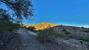


