 Route Editor

| Guide | ♦ | 13 Triplogs | 0 Topics |
details | drive | permit | forecast | 🔥 route |
stats |
photos | triplogs | topics | location |
| 137 | 13 | 0 |
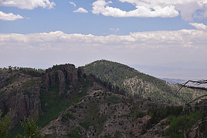
Bypass the peak by markthurman53   CREST TRAIL OVERVIEW CREST TRAIL OVERVIEWThe Crest Trails north end is along the Barfoot Park Road and continues southward to Chiricahua Peak, Sentinel Peak, and Monte Vista Peak. This trail is 14.2 miles long and divided into three sections, each traversing a ridge or crest. From Chiricahua Peak, there are three main ridges; to the north, a ridge running to Buena Vista Peak, to the southwest, a ridge running to Monte Vista Peak, and to the southeast, a ridge running to Sentinel Peak. Each of the ridges divides the trail into three sections and two side trails. THREE MAIN ⅄ LEG SECTIONS
6.2 miles: on the north side of Chiricahua Peak Crest Trail #270B - Jct Sdl to Monte Vista Pk 3 miles: Along the west side of Chiricahua Peak Crest Trail #270C - Jct Sdl to Sentinel Peak 5 miles: Along the east side of Chiricahua Peak TWO SHORT OPTIONS Crest Trail #270A - Jct Sdl to Aspen Sdl 0.9 miles: Jct Saddle > Chiricahua Pk > Aspen Sdl on the SE side of Chiricahua Pk Crest Trail #270D - Chiricahua Bypass 1.2 miles: Aspen Sdl to Chiricahua Sdl along the south side of Chiricahua Pk Access to the Crest Trail at various points can be done from Rustler Park to the north, Turkey Creek to the west, Cave Creek to the east, and Rucker Canyon to the South. Only the Rustler Park access is direct; the rest require 5 to 10-mile connecter trails with 3 to 4000 feet of elevation change. These Trails are all at around 9000 feet through heavily wooded areas, and some areas burned pretty severely over the last 20 years. The forest is in different stages of recovery. Weather can change suddenly at this elevation, and if on the trail, be prepared for whatever it can throw at you; there is no quick exit from this trail. CREST TRAIL #270D – CHIRICAHUA BYPASS Description The Crest Trail #270D is called the bypass trail but I find that kind of funny since both Crest Trails #270C and B bypass Chiricahua Peak also. This is more like a connector trail, connecting the Crest Trail #270C at Aspen Saddle to the Crest Trail #270B at Chiricahua Saddle. The east end of the trail is along the Crest Trail #270C about 100 yards south of the junction with the Ojo Agua Fria Trail #361. The trail is in good condition and easy to follow. From Aspen Saddle the trail climbs 150 feet over a ridge coming down the southwest side of Chiricahua Peak then drops down fairly rapidly 400 feet to Chiricahua Saddle. If I have an option I would prefer to do this trail east to west, less climbing. This trail is short but if you take photos be prepared to do a lot of stopping; the views over Rucker Canyon to the south are spectacular. To the west is Monte Vista Peak and closer in, Raspberry Ridge and Paint Rock, all along 270B. To the southeast the ridge that eventually leads to Sentinel Peak along 270C. To the north, uphill is Chiricahua Peak. Besides being a bypass trail, this trail makes for a great loop hike around the peak. Check out the Official Route and Triplogs. Leave No Trace and +Add a Triplog after your hike to support this local community. One-Way Notice This hike is listed as One-Way. When hiking several trails on a single "hike", log it with a generic name that describes the hike. Then link the trails traveled, check out the example. | ||||||||||||||||||||||||||||||||||||||||||||||||||||||||||||||||||||||||||||||||||||||||||||||||||||||||||||||||||||||||||||||||||||||||||||||||||||||||||||||||||||||||||||||||||||||||||||||||||||||||||||||||


