Route Editor

| Guide | ♦ | 3 Triplogs | 0 Topics |
details | drive | no permit | forecast | 🔥 route |
stats |
photos | triplogs | topics | location |
| 64 | 3 | 0 |
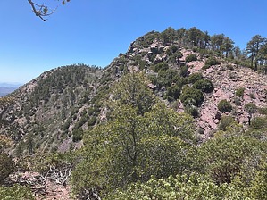
Mazatzal Triplets: The Middle Child by John10s   Overview OverviewPeak 7549 is one of three unnamed peaks of similar elevation, located in close proximity on a ridge roughly two miles southeast of Mazatzal Peak. The three peaks are positioned in a C-shape along the ridge, and 7549 is the middle of the three, both in elevation and north/south position. The highest, Peak 7579, is located to the northeast, and the lowest, Peak 7532, is located to the south. The route described here begins at Peeley Trailhead and approaches the ridge via Mazatzal Divide Trail #23. A shorter route is available via Barnhardt Trailhead and Y-Bar Trail #44, although many hikers will prefer the additional mileage on the smoother Mazatzal Divide Trail over the rocky tread on Y-Bar. Hike The three peaks are visible along FR 201 on the drive into Peeley Trailhead and remain major landmarks throughout much of the hike. After roughly a half mile on Cornucopia Trail #86, stay right at the signed AZT intersection to connect with the well-maintained Mazatzal Divide Trail #23. About a mile in, the trail climbs through some long switchbacks as you steadily gain elevation, climbing ~1,000' over the first two miles.
Continuing on the Mazatzal Divide, after passing the northwest side of Peeley, the trail takes a sharp turn to the south through a forested area, with some signs of fire-damaged trees, then generally follows the contour lines of the hillsides for the next mile and a half before turning north toward Mt. Catherine. The views start to open to the west, with impressive scenery overlooking the western Mazatzal peaks and Horseshoe Reservoir in the distance. As you approach Mt. Catherine, you'll also have a nice vantage point looking back at the ridgeline of peaks to the south, extending from Mt. Peeley to Sheep Mountain. Mazatzal Divide Trail circles around the east side of Mt. Catherine, where you'll start to encounter more fire-damaged trees, then continue north to a saddle, climbing to over 7,100' as the trail turns east toward the ridgeline. At this point, it looks like a straight shot with only ~400' of elevation gain to reach 7549, but the trail soon drops through some long switchbacks in a badly fire-damaged area, losing ~500' of elevation over the next mile. A convenient exit point to start the off-trail climb up to the peak is located near the intersection of Mazatzal Divide and Fisher Trail #230. Will you find a relatively open route to start the ascent near a sign for Bear Spring with a campsite and fire ring nearby. From here, you have ~ two-thirds of a mile and 1,000' of elevation gain remaining to reach the peak. There aren't any major obstacles along the way, which allows for a fairly direct approach to the peak. The brush isn't too dense, and the rock outcroppings are easy to navigate around or over, providing plenty of flexibility in route selection. The peak is formed from red Mazatzal quartzite, and the two other peaks in the ridgeline trifecta are easily visible: 7579 to the northeast, and 7532 to the south. The ridge drops off sharply to the east, providing wide-open views in that direction. Looking southeast, you'll see Four Peaks and Mt. Ord in the distance, and FR 201 and Peeley Trailhead are also visible down below. Though Mazatzal Peak is only ~ two miles away, trees and brush obscure most of the views in that direction. Once you've enjoyed the peak, you can return to the trail and hike out via the same route, or, having come this far, hike over to one or both of the two other high points along the ridge. Peak 7579 is the most rugged of the three and requires hiking another half mile across a shallow saddle full of manzanita, then some minor scrambling near the top, but it offers an unbeatable view of Mazatzal Peak. Peak 7532 has a flatter, slightly less brushy approach, and is located a similar distance south of Peak 7549. Check out the Official Route and Triplogs. Leave No Trace and +Add a Triplog after your hike to support this local community. | |||||||||||||||||||||||||||||||||||||||||||||||||||||||||||||||||||||||||||||||||||||||||||||||||||||||||||