Route Editor

| Guide | ♦ | 3 Triplogs | 0 Topics |
details | drive | permit | forecast | route |
stats |
photos | triplogs | topics | location |
| 40 | 3 | 0 |
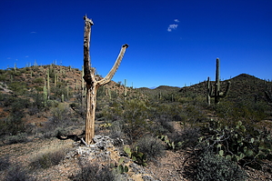
Hike through the desert to a Peak with no name by fricknaley  Background BackgroundThis is another desert scramble to a pretty nameless peak in the foothills north of Wasson Peak. It's a combo of trails, washes, and peakbagging perfect for a relatively quick jaunt into the desert. Hike From the Ringtail trailhead off Picture Rocks Road (or Box Canyon as it's officially named) take off on the wide sandy Ringtail Trail heading south into the desert. Almost immediately there is a signed trail breaking off right for the Cam-Boh Trail. Take this for less than 0.4 miles to another intersection, the Ironwood Forest Trail, breaking left. Take this scenic little trail as it wanders south into the desert proper for 1.4 miles. Along the way enjoy some marvelous views east of the Catalinas, as well as local peaks of the Tucson Mountains: Picture Rocks east, Peak 3263 and Panther Peak north, the northern Tucson mountain peaks, and Wasson to the south. There is perfect desert and thousands of saguaros along the way too. The trail ends in the wide, sandy Picture Rocks Wash.
Stay in the wash until you come to its western end, there is a false ridge right in front of it. It's about another mile (give or take a couple tenths) to this relative point. Here you will just climb steeply out of the wash and head left/east straight up the steep wall of the peak. Tread carefully to avoid cacti. Pick whatever way works for you. Near the top, I came across some prominent rocks that required more intense scrambling, but you could avoid these by angling left. When you reach the top, you will see the farther east dome is the taller of the two, easily accessible by scrambling along the rocky ridgeline connecting the two. My GPS read about 3.75 miles from the trailhead from the summit. Enjoy the views and head back the way you came. I descended the northwest side of the peak for a more easy scramble down. I hit the ridge north of the peak and headed down the west end of this back into Brittlebush Wash. You can just pick whatever route works for you. Being off-trail, please be respectful of the vegetation that's fought hard for its living and tread lightly. This is rocky country and the flora can be easily avoided off-trail.
Check out the Official Route and Triplogs. Leave No Trace and +Add a Triplog after your hike to support this local community. | |||||||||||||||||||||||||||||||||||||||||||||||||||||||||||||||||||||||||||||||||||||