 Route Editor

| Guide | ♦ | 48 Triplogs | 1 Topic |
details | drive | permit | forecast | 🔥 route |
stats |
photos | triplogs | topic | location |
| 227 | 48 | 1 |
prime rib Sonoran filet by joebartels  History HistoryGo John Canyon was saved from development in 1998 by a 1996 state law that allows state trust land to be reclassified for preservation. This small canyon contains Hohokam archaeology sites, a riparian habitat, and goodies galore. P.A. Seitts Preserves The preserve was named in honor of Patricia Ann Seitts, a former executive director for the Land Trust who was instrumental in its preservation. She was focused on saving the land for future generations to enjoy this natural treasure. At the age of 52, Patricia died as a result of colon cancer.
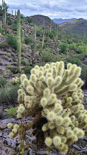
Flat Rock Trail bridges the gap between Military Trail on the east and Quartz Trail on the west. The western 0.4-mi of the trail is within the Cave Creek Regional Park boundary. The eastern 0.1-mi is in the P.A. Seitts Preserve. Hike Flat Rock Trail is short, easy to follow, and well-signed on both ends. It is a great trail in the upper fork of Go John Canyon. Hiking east to west, the trail gently ascends 142 feet. There are no major ups, downs, turns, or concerns along the trail. Dominate views to the northeast include Skull Mesa, Quien Sabe and Continental Mountain. Two varieties of cholla pepper the terrain but keep an eye out for Parish's goldeneye. A few barrel cactus, a bunch of jojoba, Palo Verde and a hint of catclaw. Fear not, the trail is dreamy, you do not touch any of the brush unless you jump off-trail. Wolfberry was loaded with edible berries alongside the trail if you crave unsweetened Lycium acid. Some "claim" they are yummy and they are safe to sample. Curve-billed thrashers were the dominant songbirds on my trip. I saw more tiny lizards than on the previous trail, Javelina scat was noted more than once. Synopsis Better than anticipated. Despite deadly humidity, distant views, tread, and flora extended the joy found along the Military Trail. A loop out here might be worth your time if you are not fixated on carrying a kitchen sink on your back through mountains in Colorado. Check out the Official Route and Triplogs. Leave No Trace and +Add a Triplog after your hike to support this local community. One-Way Notice This hike is listed as One-Way. When hiking several trails on a single "hike", log it with a generic name that describes the hike. Then link the trails traveled, check out the example. | ||||||||||||||||||||||||||||||||||||||||||||||||||||||||||||||||||||||||||||||||||||||||||||||||||||||||||||||||||||||||||||||||||||||||||||||||||||||||||||||||||||||||||||||||||||||||||


