Route Editor

| Guide | ♦ | 1 Triplog | 0 Topics |
details | drive | permit | forecast | route |
stats |
photos | triplog | topics | location |
| 59 | 1 | 0 |
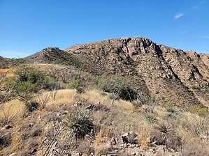
Two Elephants viewpoint by Mike_W  Overview OverviewYoas Mountain is a high point southwest of Elephant Head and northwest of Little Elephant Head. Note, that the mountain peak is lower than the trailhead elevation, so there's a good amount of downhill and then uphill for this hike. The hike involves roughly 2.8 miles of well-maintained trail and sections of 4x4 road, and about 1 mile of bushwhack which isn't bad if you stay in the canyon, away from the catclaw and are able to navigate around a lot of ocotillo on the various hillsides. Hike Start off walking up the Elephant Head Bike Trail #930. This trail is fairly well-maintained and easy to follow. After roughly 1 mile you will reach a junction. The trail going up is the Quantrell Mine trail and the trail going down is the Chino Basin Trail. You will take the Chino Basin Trail down which is an old 4x4 road. Take this road downhill and after hiking a total of 1.7 miles you will see a sign on the right that marks the old Elephant Head Mill Site. The sign references some old adobe walls at this location, but as of November 2022, I looked around very carefully but didn't see any walls or adobe structures here. About 7 or 8 years ago, I remember seeing some adobe walls when I hiked in this area before. I'm interested in knowing what happened to those walls. Anyway, continue walking down the 4x4 road. Within a few minutes, you will see a metal gate in this trail which prevents vehicles from driving up but hikers are allowed the walkthrough. After hiking a total of 2.7 miles from the trailhead, turn left on a road junction and follow that for about 500 feet. After that, you will need to bushwhack west about 50 feet up in elevation so that you can see Yoas Mountain. From there you should have an idea of where you need to hike to summit this peak.
At the peak, there were some great views of both Elephant Head, to the northeast, and Little Elephant Head, to the southeast. You should be able to see Mt Wrightson and Mt Hopkins in the distance to the east/southeast. You'll see a registry at the top under a pile of rocks. On the way down, hike down to the same canyon you came up from. Once in the canyon, if it is dry, you could follow it down to the point referenced above until you see a 50 or 60-foot drop-off. From here there are some nice photos. Next, you'll need to hike back up the canyon and stay left to go around the cliffs. Then, you'll need to descend northeast toward a lower saddle. From that lower saddle hike East until you see a road below. Take that road north until you reach the main Chino Basin road. Make a right and walk up the hill roughly 1.5 miles to the junction. Turn right and follow the Elephant Head Bike Trail back to the parking area. My uploaded route also shows some exploration I did on the lower part of the Chino Basin Trail and FS 4073, before heading back up to the trail junction. FS 4073 is a pretty rough road, but with a high clearance 4x4 vehicle, it may also be possible to start this hike from somewhere along this road. Gate Policy: If a gate is closed upon arrival, leave it closed after you go through. If it is open, leave it open. Leaving a closed gate open may put cattle in danger. Closing an open gate may cut them off from water. Please be respectful, leave gates as found. The exception is signage on the gate directing you otherwise. Check out the Official Route and Triplog. Leave No Trace and +Add a Triplog after your hike to support this local community. | ||||||||||||||||||||||||||||||||||||||||||||||||||||||||||||||||||||||||||||||||||||||||||||||||