Route Editor

| Guide | ♦ | 1 Triplog | 1 Topic |
details | drive | permit | forecast | 🔥 route |
stats |
photos | triplog | topic | location |
| 60 | 1 | 1 |
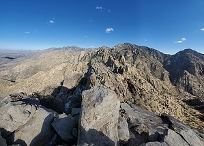
You need a lot of energy and wisdom to get up this tooth! by Mike_W  Overview OverviewIn my opinion, climbing to Table Tooth is one of the more difficult hikes in the Tucson area. In terms of difficulty, I'd rank this one right up there with Table Mountain, Valentine Peak, Finger Rock Guard, and Cathedral Rock via the Esperero trail. This hike has from 2 to 3 miles of difficult and steep bushwhack, depending on your route. There's also some rock climbing near the top. But, the overall elevation isn't quite as high as Table Mountain. If you've climbed Table mountain before and enjoyed it, you'll probably enjoy this one also. Warning Before you attempt this hike, please read the guide for Table Mountain. Understand that this hike is longer, just as difficult, if not more difficult, and involves some very steep sections of bushwhacking, and a rock climb area about 500 feet from the summit with some exposure.
Note About 5 years ago, the Pima Canyon Trail was not so well maintained, but thanks to some volunteer workers and some Forest Service workers, this trail is in much better shape today, in my opinion, especially for the first 2-3 miles. On at least 2 occasions in the last 6 months, I met an older couple who were doing maintenance work on the trail and were in a group called Friends of the Catalinas. They deserve a lot of credit for the improvements they have made. It has been noticed by many hikers. Hike Start by taking the recently well-maintained Pima Canyon Trail. You will take this trail for about 4.1 miles, then look for a wash crossing. The trail continues across the wash and starts to climb up the other side. You will make a left turn at the wash before the trail starts to climb up. From here you will be in the canyon for a while. Take your time and watch out for loose rocks. Some areas with huge rock formations are easy to walk across. There are other locations with obstacles to go around or climb over. After hiking a total of 4.3 miles, you should encounter a junction in the wash. Take the left branch and continue until you have hiked a total of 4.6 miles. Exit the canyon on the right side and climb up to the high point in the ridge. If you look up, you should see Table mountain to the Northwest. From here keep climbing up the steep ridge. You will want to head due North and cross this canyon to your right, if possible. It is important to check your coordinates often on this uphill section and compare it to your planned route. That will save you some time. Note: I didn't go far enough to the right and ended up climbing to the saddle between Table Mountain and Table Tooth, which wasn't necessary, but the views from this saddle were quite amazing. There were a few patches of snow on this saddle, especially on the North side. According to the topo map, it appeared that there was a way to get to the top of Table Tooth from this saddle but my opinion is there was not any safe way, especially without ropes. Therefore, I realized it was necessary to work my way around to the correct saddle, which is Southeast of the Table Tooth summit, rather than Southwest. Luckily the Southwest saddle is only about 600 feet away from the Southeast saddle, but the bad news is there were some obstacles such as boulders, trees, and various cacti in the way. Once at the saddle Southeast of Table Tooth, you will want to continue Northwest and keep going up. There weren't any cairns here but you should be able to see where to go. There were a few small spots of snow in late February when I was here, but nothing large enough to cause any danger in terms of slipping. At about a distance of 500 feet from the summit, you'll see a 20 or 30-foot rock wall that has a ramp going right, then a ramp going left, and then perhaps another ramp going right again. This is the exposed area that was mentioned earlier. If you are not comfortable climbing, don't attempt this. Instead, see the description written by Paul McClellan, along with his photo of the area, which documents a way to reach the summit by skipping the exposed rock climb. If you are not afraid of heights and comfortable with climbing you can take this climb step by step. If there's any point where you don't feel comfortable continuing, you can always reverse your steps back to the bottom by walking down the rock "ramps". At the top of the higher ramp, there was a 5 or 6-foot vertical section that had two good solid hand grips, in my opinion, at the top. I was able to get a firm grip above & behind these rocks, test the strength of these grips, and then pull myself up. Make sure you will be comfortable coming down this section also, which is how I came down a few minutes later. After you get over this steep rocky section, getting to the summit is easier. Just keep working your way up and be careful not to get too close to the edge because there are some vertical drops on both sides of the summit. From the summit, there are amazing views of Table Mountain, the town of Oro Valley and Catalina, and Mt Kimball to the East/Southeast. You will see a registry in a metal box at the summit. The oldest entry I saw was from 1977. Even with a GPS device, it was a bit tricky to go back down the same way. I took several wrong turns and needed to backtrack in at least 2 different places on the way down to the saddle from the peak. If I had more time, I would have placed a few cairns. If it is getting later in the day, your goal should be to make it to the trail or main part of Pima canyon before dark. Bushwhacking down the steep section below the saddle in the daytime is hard enough. It's hard to imagine how difficult that might be at night. Check out the Official Route and Triplog. Note This is a difficult hike. Arrive fit and prepared or this could get ugly. Leave No Trace and +Add a Triplog after your hike to support this local community. | |||||||||||||||||||||||||||||||||||||||||||||||||||||||||||||||||||||||||||||||||||||||||||||||||||||||||||||||||||||