 Route Editor

| Guide | ♦ | 8 Triplogs | 0 Topics |
details | drive | permit | forecast | 🔥 route |
stats |
photos | triplogs | topics | location |
| 62 | 8 | 0 |
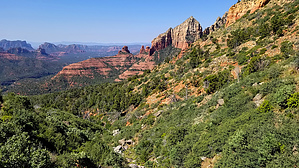
outta the skillet red rock feature tour by joebartels   Overview OverviewSemi avid loop on various terrain. You will pass four iconic Sedona features with a healthy dose of red rock, garnished with Arizona Cypress. Hike Ascend 2.15 mi up North Wilson Mountain Trail #123. It's a hearty 1,545 ft up and midway across First Bench of Wilson Mountain to Wilson Mountain Trail #10.
Following the Official Route for this guide, you can avoid the Jordan Trailhead by crossing the road where Jim & Jordan get close. Then follow Jordan Trail 0.2 mi to Cibola Pass Trail. Jordan & Cibola don't get social luv but I'm a fan of the twisted Arizona Cypress. An 0.65 mi stroll on Cibola is a shortcut to the end of Jordan. In about 0.35 mi you arrive at Devil's Kitchen. Experienced technical climbers can add in the class four Morning Glory Spire. Merge onto Soldier Pass Trail #66 heading north. In 0.35 mi you pass the Seven Sacred Pools. Follow the Official Route closely for 1.0 mi & 500 ft to Soldier's Arch. Carefully crawl up through the arch to Brins Mesa. It's about a third of a mile to merge onto Brins Mesa Trail #119. Along the way you might be near Hole in the Sky. Next, hike the least two exciting segments. 2.0 mi WNW to Brins Mesa Trailhead 1.9 mi N then NE on FR 152 to Vultee / Bear Sign Trailhead. Rejoice and continue a leisure 1.6 mi / 380 ft E on Vultee Arch Trail #22 to a view of Vultee Arch. Wolf down a bowl of Wheaties for the 1.1 mi / 770 ft ascent to Sterling Pass. Rest. Admire. Drop 1.1 mi / 1,100 feet to Sterling Trailhead.
Check out the Official Route and Triplogs. Note This is a moderately difficult hike. Leave No Trace and +Add a Triplog after your hike to support this local community. | |||||||||||||||||||||||||||||||||||||||||||||||||||||||||||||||||||||||||||||||||||||||||||||||||||||


