username
X
password
register
for free!
help
  
  🔥

Superstition Peak 5057 Loop via Hiero, AZ

Guide 66 Triplogs  3 Topics
  4.1 of 5  
Fav
Wish
9
details
drive
no permit
forecast
🔥
route  
stats
photos
triplogs
topics
location
657 66 3
Statistics
tap row or icons for details
Difficulty 3 of 5
Route Finding 2 of 5
Distance Lasso-Loop 13.25 miles
Trailhead Elevation 2,081 feet
Elevation Gain 2,953 feet
Accumulated Gain 3,533 feet
Avg Time One Way 5-7 hours
Kokopelli Seeds 25.02
 Interest Seasonal Waterfall, Seasonal Creek & Peak
 Backpack Possible - Not Popular
feature photo
Photos Viewed All MineFollowing
Inaugural Calculation on Button Tap!
20  2025-01-31
Superstition Peak 5057 - Balanced Rock Loop
The_Eagle
14  2025-01-16 fricknaley
6  2024-05-15 pseudalpine
39  2023-12-28
Hieroglyphic - 5057 - 3 Sisters - Shaka Loop
John10s
5  2023-09-13 pseudalpine
12  2023-02-05 adv_trev
1  2021-03-24 pseudalpine
19  2020-12-20 rayhuston
Page 1,  2,  3,  4,  5,  6
Author
author avatar Guides 59
Routes 1,100
Photos 1,176
Trips 1,290 map ( 9,859 miles )
Age Male Gender
Location Arizona
Associated Areas
list map done
Phoenix Region
Historical Weather
Trailhead Forecast
Radar Map
Expand Map
Preferred Nov, Dec, Jan, Feb → 6 AM
Seasons   Autumn to Spring
Sun  6:02am - 6:47pm
Official Route & 11 Rts
 
8 Alternative
 
Historic Fire Perimetersacres
🔥 2024 Siphon Fire35.9 mi*
🔥 2020 Superstition Fire9.6k
🔥 2020 Sawtooth Fire24.7k
🔥 2019 Woodbury Fire123.8k
🔥 View (All) - over Official Route 🔥
*perimeter length in miles


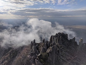
This Ain't No Overrated Forest Bath
by pseudalpine

  
Overview
Two thirds of the time, conditions will likely dictate hiking this loop in a CW direction. It depends mostly on the season with tolerance of heat as the most important consideration and whether you want to start with the sun directly in your eyes, complete certain bushwhacky parts before the snakes are active and/or you wish to complete the steep uphill at the beginning or middle part of the hike. America is great enough in that you get to decide what's best for you. Be prepared or this could get ugly.


Hike
The official CW route utilizes the complete Hieroglyphics Trail #101, upper Hieroglyphic Canyon, an east central section of the Superstition Ridgeline, an easy dogleg spur to the peak, a descent to the West Boulder Saddle that passes through Carney Spring Canyon and the central-eastern section of the Lost Goldmine Trail. Besides the summit block, only one section of this route (CW three-mile mark) has a scramble (maybe cl.3) that is colloquially known as Just Look Away. You'll get the drift if you've spotted a partner who'd never scrambled this type of terrain before. Someone has recently stacked some rocks at the base of this ledge to make it easier to negotiate. The rest of the route is fairly obvious to anyone with a bit of route-finding experience.
remove free decal offer
Synopsis
This hike is one of the better loops in the Supes. Currently, it's somewhat overgrown with Desert Globemallow in the middle section near the Three Sisters. Overall, this doesn't qualify as a gnarly bushwhack like some of the other routes posted on HAZ, especially the far eastern trail loops.

2024-05-15 pseudalpine


    Check out the Official Route and Triplogs.
    Leave No Trace and +Add a Triplog after your hike to support this local community.

    One-Way Notice
    This hike is listed as One-Way.

    When hiking several trails on a single "hike", log it with a generic name that describes the hike. Then link the trails traveled, check out the example.
    WARNING! Hiking and outdoor related sports can be dangerous. Be responsible and prepare for the trip. Study the area you are entering and plan accordingly. Dress for the current and unexpected weather changes. Take plenty of water. Never go alone. Make an itinerary with your plan(s), route(s), destination(s) and expected return time. Give your itinerary to trusted family and/or friends.

     Permit $$
    None


     Directions
    or
     Road
    Paved - Car Okay

    To Hieroglyphics Trailhead
    From the East Valley follow US 60 East to South Kings Ranch Road. Kings Ranch Road is 14.1 miles east of Power Road for reference. Turn North on Kings Ranch Rd and follow to 2.8 miles to Baseline. Turn East on Baseline and follow 0.2 miles to Mohican. Turn North onto Mohican and follow 0.4 miles to Valleyview Road. Turn West onto Valleyview and follow (naturally turns North, and turns into Whitetail Road) for 1.4 miles. At the intersection of Whitetail Rd. and Cloudview Road turn East and follow 0.4 miles to the end. The trailhead parking is here and the trail is easy to spot to the East. If the parking lot is full, please do not park illegally or on private property!

    From PHX (I-10 & AZ-51) 42.9 mi - about 54 mins
    From TUC (Jct 1-10 & Grant) 95.3 mi - about 2 hours 3 mins
    From FLG (Jct I-17 & I-40) 187 mi - about 2 hours 58 mins
     90+° 8am - 6pm kills
    helpcorrectionissue

    end of page marker