Route Editor

| Guide | ♦ | 29 Triplogs | 0 Topics |
details | drive | permit | forecast | map |
stats |
photos | triplogs | topics | location |
| 107 | 29 | 0 |
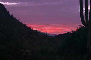
Secluded Saguaros by fricknaley  Cactus canyon is simply one of many trails in the northern region of the Tucson Mountain District of Saguaro National Park West. There is a whole network of short trails off Picture Rocks Road that can be combined in several routes and loops. I'll call this route Cactus Canyon because that is the destination leg of the route we did, and it is very scenic and typifies the Saguaro West region. Cactus canyon is simply one of many trails in the northern region of the Tucson Mountain District of Saguaro National Park West. There is a whole network of short trails off Picture Rocks Road that can be combined in several routes and loops. I'll call this route Cactus Canyon because that is the destination leg of the route we did, and it is very scenic and typifies the Saguaro West region.Start by crossing Picture Rocks Road and taking off down the wide sandy wash across from the parking area. Cross through a gate and see a sign that announces you are on the Ringtail Trail. This quickly narrows out to an easy to follow trail. A sign for Cam-Boh Trail breaks off to your right, soon after by Mule Deer Trail. Keep to your left and travel away from the road. The surrounding area quickly becomes very scenic with close and distant peaks and smaller canyons all around you. The trail winds around, mildly up and down. After a mile, the trail ends up in a cross-cutting wash, the Picture Rocks Wash. Hang a right here and follow the wide sandy wash for 0.4 miles.
At the wash, hang a left and continue southwest down it. The wash narrows down and becomes much more interesting. After 0.3 miles, the signed takeoff for Ironwood Forest trail breaks out off to your right. Follow this for 1.4 miles through the desert as it winds and climbs in and out of little washes and ravines. After 1.4 miles, a signed Mule Deer Trail takes off to your right. Follow this through similar country as you angle your way back to the road. In 0.3 miles, you are back at the Ringtail trail. Hang a left, and quickly you arrive back at the road and your car. Gate Policy: If a gate is closed upon arrival, leave it closed after you go through. If it is open, leave it open. Leaving a closed gate open may put cattle in danger. Closing an open gate may cut them off from water. Please be respectful, leave gates as found. The exception is signage on the gate directing you otherwise.
Check out the Triplogs. Leave No Trace and +Add a Triplog after your hike to support this local community. | ||||||||||||||||||||||||||||||||||||||||||||||||||||||||||||||||||||||||||||||||||||