Route Editor

| Guide | ♦ | 27 Triplogs | 0 Topics |
details | drive | permit | forecast | map |
stats |
photos | triplogs | topics | location |
| 372 | 27 | 0 |
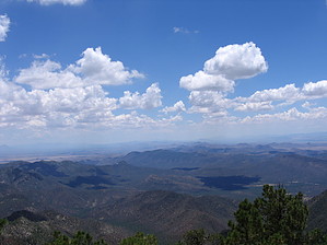
Southern Arizona High Life by fricknaley  In my opinion, the best warm-weather hiking in southern Arizona is in the Chiricahuas. There are endless opportunities there. Here's a loop that incorporates some of the best in the Chiricahua Mountains: a great climb, temperature escaping altitudes, wildflowers, a tremendous high-country ramble along the Crest Trail #270, and bagging two of the significant peaks in the range (one the highest, the other with a sensational lookout and unbelievable views). This is the sky islands at their best. In my opinion, the best warm-weather hiking in southern Arizona is in the Chiricahuas. There are endless opportunities there. Here's a loop that incorporates some of the best in the Chiricahua Mountains: a great climb, temperature escaping altitudes, wildflowers, a tremendous high-country ramble along the Crest Trail #270, and bagging two of the significant peaks in the range (one the highest, the other with a sensational lookout and unbelievable views). This is the sky islands at their best.Start this loop from the Mormon Ridge Trailhead/Mormon Ridge Trail #269 on the left side of the dirt road. The trail crosses over Turkey Creek, where we saw fresh bear tracks, then continues up. This trail will ultimately climb about 3,000 feet as it climbs and switchbacks up Mormon Ridge. Mormon Canyon falls down to the south; on the other side of the ridge is North Ward Canyon. This part of the trail is pretty tough. There are increasingly nice views, with spires projecting out on either side of the ridge as you look out. Around 2 miles in or so, you will pass an old Wilderness Boundary sign. There are stretches as you climb out of the oak forest and enter the pines, where you will pass through burned areas. After the burned areas, there is a fantastic old-growth pine forest, with moss-covered pines and aspens peaking through. This is great. Finally, after climbing to over 9,000 feet, the Mormon Ridge trail will dead-end at the Chiricahua Crest Trail. This is a little over 4 miles in.
Finally, you will come to a saddle and major trail intersection. Hang a right and catch the Peak trail to the top of Chiricahua Peak. The trail is faint at times, as it climbs over and around some old burned trees but never too hard to follow. At 9,757 feet, the summit of Chiricahua Peak is the highest in the range. The views from the summit itself aren't the best, but that's not the point here. Small armies of aspens are claiming the peak from the burned pines, and there are colorful flowers everywhere. Head back down the way you came, and go back along the Chiricahua Crest trail back to your intersection with the Mormon Ridge. Now continue south on the Crest Trail and be prepared to be blown away. As you ramble along between 9,100-9,200 feet for about 2.5 miles along this trail, there are unbelievable views all down the range and major canyons. Nice flowers along the way. Fern forests everywhere. Rock spires protecting peak after peak. You will pass Paint Rock along the way. The best part of the hike is along this route. You will pass a signed intersection where Raspberry Ridge joins up from the left; keep going straight. Finally, after nearly 3 miles, you will come to the signed intersection for Johnson Peak and Turtle Peak to your right. First, hang a left here and climb steeply for a short distance to summit the fantastic Monte Vista Peak (9,340 feet) with its functional lookout and jaw-dropping panorama views of the Chiricahuas and far, far beyond. Definitely, a place to spend some time. Head back down to the signed intersection. Now follow the route towards Johnson Peak. In about 1.5 miles of steady descent through fantastic pine, then burned pine forest, you will reach the last intersection. Here you hang a right and follow Morse Canyon Trail #43 down it's namesake canyon. This is a steep descent for about 2.5 miles to the end of Turkey Creek Road. This trail is easy to follow and covered by forest the whole way down. It's a nice, peaceful, and secluded trail that loses a lot of elevation in a relatively short distance. It dead-ends at the forest road, which dead-ends at the trail. Follow the road back about two leisurely miles to your car. Coronado FS Details Saulsbury Trail #263, Mormon Ridge Trail #269 & Mormon Canyon Trail #352 These three trails lead from the road up West Turkey Creek (FR 41) to the Crest Trail in the vicinity of Chiricahua and Flys Peak. Since their trailheads are all located fairly close together they offer a number of possibilities for loop routes into the Chiricahua Wilderness high country. Saulsbury Trail leads up the canyon of the same name to the north and east, then climbs up and out of the canyon and over Little Bull Mountain to its junction with the Crest Trail. This route offers good views of West Turkey Creek Canyon, Rock Creek Canyon and the Sulphur Springs Valley. It can be hot if you traverse it during midday. Mormon Ridge and Mormon Canyon Trails are both located south of Saulsbury and are aimed almost directly at Chiricahua Peak. Mormon Ridge is quite steep and many choose to follow it down, rather than up, if they use the trails to form a loop. Since it clings to the south-facing slope of Mormon Canyon, it can also be quite hot. These trails cross near the head of Mormon Canyon. From that junction, Mormon Ridge goes north toward Cima Park and Mormon Canyon goes south to Chiricahua Saddle. Both are points along the Crest Trail #270. These trails traverse a wide range of biologic zones. Starting out among plants characteristic of the Upper Sonoran Desert such as Schott’s yucca and silverleaf oak, the trails climb into a forest of Engelmann spruce, a species found as far north as British Columbia. Mormon Canyon Trail passes through a picturesque riparian area that includes a number of Rocky Mountain maples. Those who visit in autumn will want to pass this way and enjoy the fall colors. Attractions: High country loops, Canyon and mountain views, Biological diversity, Riparian area & Fall colors Notes: Saulsbury Trail is 4.4 miles long (4 miles in Chiricahua Wilderness); Mormon Ridge Trail is 4.5 miles long (3 in Wilderness); Mormon Canyon Trail is 3.4 miles (2.7 in Wilderness). All three of these trails connect to the Crest Trail #270. Check out the Triplogs. Note This is a difficult hike. It would be insane to attempt this entire hike without prior experience hiking. Leave No Trace and +Add a Triplog after your hike to support this local community. | |||||||||||||||||||||||||||||||||||||||||||||||||||||||||||||||||||||||||||||||||||||||||||||||||