| | -
-
-
| |  |
|
1 |
-
-
-
-
-
-
| 1 label | 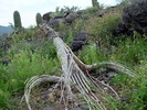 |
|
|
-
-
| 1 label |  |
|
2 |
-
| 1 label | 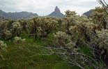 |
|
1 |
|
| | |
|
| Hiking | 6.70 Miles |
1,125 AEG |
| | Hiking | 6.70 Miles | 4 Hrs | | 1.68 mph |
| 1,125 ft AEG | | | | |
|
|
| |
| Linked |
|
none
[ show ]
| no linked trail guides |
| Partners |
|
none
[ show ]
| no partners | | I didn't do the traditional loop.
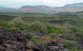
Just after the 1st saddle (before Parker Pass which I call Stingray as that's what it looks like from overhead) I attempted to follow the old topo road continuation.
There were faint paths or trails of use in sections but it's a far cry from ever being a road as I suppose it was in the past. At the end is a white slope section that appears to be caliche cement or something. I don't know the history of this spot.
I headed up to the yellow band so many view walking by and aimed for a narrow section on the left/north. Somehow I just lost my mind and scaled a ten foot wall. It must not be too rough or I wouldn't have made it. I will say that you do have to make a move that pretty much commits yourself to continuing or falling to death. But then again you might be able to just skirt around the whole thing too.
On top it's very evident why this is called Black Mesa. I walked through a hearty section of black rocks to the southern overlook. Next I headed down northeast for the Black Mesa Trail. The ground was super spongy in sections and almost seemed like marshlands due to the recent rains.
I entered the dreaded cholla forest. It started off pretty tame. For the most part it wasn't bad at all, it just never seemed to end... then right before picking up the trail it gets very thick. I had to double back a couple times. I came across an old alignment of the trail which suckered me into pure joy. Luckily the real trail was just a few cactus wounds further. Just kidding, I made it through without incident.
It was an interesting hike that I've had on my todo list for years. I doubt I'll specifically come back to the area. |
| _____________________
| | |
|
|
|
|
|
| |
 Route Editor


