| | -
-
-
| 2 labels |  |
|
15 |
-
-
-
-
| 1 label | 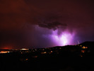 |
|
2 |
|
| | |
|
| Hiking | 2.80 Miles |
1,011 AEG |
| | Hiking | 2.80 Miles | | | |
| 1,011 ft AEG | | 6 LBS Pack | | |
|
|
| |
| Linked |
|
none
[ show ]
| no linked trail guides |
| Partners |
|
none
[ show ]
| no partners | | After waiting forever at the Mount Tritle/Trail 65 trailhead for the rain to stop, I gave up and drove south to hike Tritle from FR 52B again. I drove FR 52B for a short ways, then continued on foot, meeting two other hikers along the way. I was treated to a great sunset on top, but a rapidly developing thunderstorm sent me down a short time later. A short distance down from the top the deluge began, and I was walking in a full downpour, soaked. A few nearby blasts of lightning spurred me on as I approached my truck. I hoped that those other two guys had descended from the peak. 
I drove home along the Senator Highway, romping through puddles of muddy water, and listening to hilarious songs of white trash living, while all around me lightning flashes illuminated the driving rain. It was a great adventure in a pretty area.  |
| _____________________
| "…you never know when a hike might break out" -Jim Gaffigan |
| | |
|
|
|
|
|
| |
 Route Editor


