| | -
| 1 label | 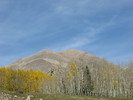 |
|
|
-
-
| 1 label | 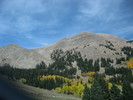 |
|
1 |
-
-
-
-
-
| |  |
|
1 |
-
-
-
| 1 label | 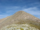 |
|
|
-
-
-
-
|
| | |
|
| Hiking | 5.50 Miles |
2,750 AEG |
| | Hiking | 5.50 Miles | 3 Hrs 45 Mns | | 1.47 mph |
| 2,750 ft AEG | | | | |
|
|
| |
| Linked |
|
none
[ show ]
| no linked trail guides |
| Partners |
|
none
[ show ]
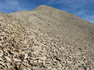
| no partners | | | I parked just east of La Sal Pass and hiked up to that and then utilized the common gully route to access Mount Peale. At 12,721', Peale has a very Humphrey like feel to it, wind shelter and everything. Just lacked humans. I hiked down a social trail to a two track numbered "4725", and took that to the La Sal Pass road. Cooked up diner and spent the night camped at roughly 10,000'. The color out here was great, and the trip was well worth the drive, which is only another hour round trip compared to Flagstaff. I highly recommend the La Sal mountains in late September. |
|
Autumn Foliage Observation Extreme
|
|
| _____________________
| | |
|
|
|
|
|
| |
 Route Editor


