| |
| Highline - Rim View Fail - Webber - Donahue, AZ | | -
-
| 1 label | 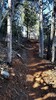 |
|
|
-
| 1 label | 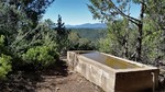 |
|
6 |
-
| 1 label |  |
|
|
-
-
-
| 1 label | 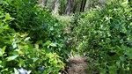 |
|
|
-
-
-
-
-
-
-
|
| | Highline - Rim View Fail - Webber - Donahue, AZ | | | |
|
|
Highline - Rim View Fail - Webber - Donahue, AZ
| | |
|
| Hiking | 25.03 Miles |
5,020 AEG |
| | Hiking | 25.03 Miles | 11 Hrs 39 Mns | | 2.37 mph |
| 5,020 ft AEG | 1 Hour 4 Mns Break | 14 LBS Pack | | |
|
|
| |
| Partners |
|
[ show ]
| partners | | Me and my squad of one, launched from the Pine TH on a glorious Saturday morning.
This was my first time on this portion of the re-routed Highline #31, since starting the AZT in 2010. It was a clear and pleasant jaunt all the way to the Geronimo TH on this well manicured track. One AZ Black buzzworm woke us up about 5 miles in, sunning itself in the trail. We lounged in the shade by the babbling Webber Creek before continuing on the Highline.
The plan was to loop on the Rim View Trail - BSA, using a 4 year old @Grasshopper/ @Tough_boots track. It started out easy enough following the trail and metal poles. This was probably some scouts work for a merit badge. I don't think it's seen any love since it completion. 1 mile in, we lost the poles and any sign of a trail. We searched higher than the track and found one last pole. In shorts and wasting time with 3ish miles left into the unknown, we retreated.
The Highline back to Gerinimo #240 and the to the gem of the hike, East Webber #289. The forest is beautifully thick with maples. As an added treat, the creek was running up to and past where this trail meets up with the BSA Milk Ranch Trail. After this intersection, the trail gets...steep. We bagged the top a bit after 5pm.
First time on the Donahue #27. Clear and OK up top, gets a bit tight and rocky at the bottom. It was good to be back on the Highline superhighway to the TH.
Great weather in the Rim country made this a good one for me. |
|
Wildflowers Observation Light
|
|
 |
Geronimo Spring |
Gallon + per minute |
Gallon + per minute |
| |  Water running over trail is best source Water running over trail is best source |
 |
Pine Spring |
Dripping |
Dripping |
| | | Water running over the trail. You could filter if you had to. |
|
Red Rock Spring |
Quart per minute |
Quart per minute |
| | | Catchment is full. Murky, but filterable. | | _____________________
There is a very fine line between "hobby" and "mental illness."
Dave Barry  |
| | |
|
|
|
|
|
| |
 Route Editor


