DESTINATION Generic 75 Photosets
| |
| Benchmark Hunting Hill 3692, CA | | -
-
| 1 label | 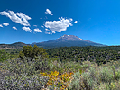 |
|
1 |
-
| 2 labels | 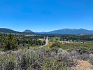 |
|
|
-
| 2 labels | 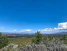 |
|
|
|
| | Benchmark Hunting Hill 3692, CA | | | |
|
|
Benchmark Hunting Hill 3692, CA
| | |
|
| Hiking | 0.57 Miles |
167 AEG |
| | Hiking | 0.57 Miles | 38 Mns | | 0.90 mph |
| 167 ft AEG | | | | |
|
|
| |
| Linked |
|
none
[ show ]
| no linked trail guides |
| Partners |
|
none
[ show ]
| no partners | | A small hill about 5 minutes from my house is shown on most topo maps as having a benchmark on its summit. This benchmark is listed in the NGS database with a PID MX1036, named “3692”, it’s determined elevation at the time of being monumented. Later maps show elevations of 3698 & 3699. Interestingly, the NGS data sheet lists the date monumented as unknown. The last recovery date is listed as 1952, some 70 years ago.
I parked at the bottom of the hill, on an old dirt road that once was the original railbed of the Weed Lumber Company Railroad. A steep 4WD track about .15 miles straight up took me to the top. The hill is primarily populated by sage, creosote and manzanita, as I believe a fire had swept through here a couple of decades ago. The hill is on national forest land. Once I got to the top, it is evident that sometime in the past some dozer work had been done, as it looked like the top had been flattened. Additionally, it’s evident that the hill is occasionally used as a party spot. Neither situations bode well for finding an intact mark after 70+ years. And such was the case. The search area isn’t very big; I overturned rocks and looked under some brush, but could find nothing.
The views from the top were nice. |
| _____________________
| | |
|
|
|
|
|
| |
 Route Editor


