DESTINATION Generic 449 Photosets
| |
| Mount Shasta South Slope Stuff, CA | | -
| 2 labels | 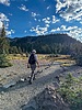 |
|
|
-
| 1 label | 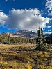 |
|
|
-
| 3 labels | 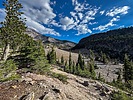 |
|
|
-
-
| 1 label | 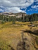 |
|
|
-
| 2 labels | 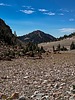 |
|
|
-
| 1 label | 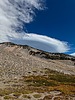 |
|
|
-
| 1 label | 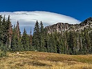 |
|
|
|
| | Mount Shasta South Slope Stuff, CA | | | |
|
|
Mount Shasta South Slope Stuff, CA
| | |
|
| Hiking | 6.34 Miles |
1,642 AEG |
| | Hiking | 6.34 Miles | 4 Hrs 46 Mns | | 1.49 mph |
| 1,642 ft AEG | 30 Mns Break | | | |
|
|
| |
| Linked |
|
none
[ show ]
| no linked trail guides |
| Partners |
|
none
[ show ]
| no partners | | After moving back to the area over 7 years ago (my parents moved us to the Bay Area in 1963 when I was 5), I finally got to do some hiking on Mount Shasta itself.
My friend Bruce and I head up the mountain out of the city of Mount Shasta on the Everett Memorial Highway to near the Old Ski Bowl. We parked at the Panther Meadows Campground, where we struck out on the trail leading towards "The Gate" and South Gate Meadows. We started out at about 7450 feet, and it's pretty much a steady climb to 7780 feet at the bottom of South Gate Meadow, with a few small dips along the way.
Out of the lower end of Panther Meadows, you hike up, traversing a gap between the end of small unnamed ridge to the north, and Gray Butte to the south, then turning northwest as you climb gradually to "The Gate", a gap between Sargents Ridge on the north side, and Red Butte to the south (about 1.52 miles from the start). Hiking east along the end of Sargents Ridge, you come to the bottom of South Gate Meadows, .8 miles from The Gate, and at about 7780 feet. From there, we hiked up the slope to the top end of the meadows, where there are a couple of springs.
We head back to The Gate, where we took the trail to the Old Ski Bowl, where we ascended the unnamed ridge that we had first travelled at the foot of, and then descended to the parking lot of the Old Ski Bowl. From there we, we caught the trail at the top of Panther Meadows, using that to get back to our car at the campground.
It was a beautiful day, about 78 degrees, pretty much sunny, with a lenticular cloud forming at the summit as we finished our hike.
GPS route: [ custom map ] |
| _____________________
| | |
|
|
|
|
|
| |
 Route Editor


