| | -
-
| 1 label | 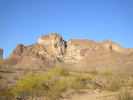 |
|
1 |
-
-
-
| 1 label |  |
|
|
-
| 1 label |  |
|
|
-
| |  |
|
2 |
-
| |  |
|
2 |
-
-
| |  |
|
3 |
-
|
| | |
|
| Hiking | 4.16 Miles |
2,100 AEG |
| | Hiking | 4.16 Miles | 3 Hrs 18 Mns | | 1.26 mph |
| 2,100 ft AEG | | | | |
|
|
| |
| Linked |
|
none
[ show ]
| no linked trail guides |
| Partners |
|
none
[ show ]
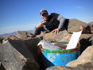
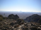
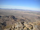
| no partners | | | A peak calling my name so I had to answer her call. The drive in on the dirt road is route 8201 which at the 2.6 mile mark I parked and started the hike on the east side of the mountain. Purposely didn't read up on everyone's routes up so I could find my own way. After looking at the chute straight in the middle I decided to head up it a bit before it came to a complete wall to climb. Once I saw that I diverted south up a wash which led me to a cliffed out ridge. I worked my way down a bit on the south side and traversed to the west side where I found the opening I wanted. I hit the south summit first as I had to get up there after seeing it close up, the sheer drop off was amazing to see. It is a knife like ridge that offers great views to the south. After that I decided to hit the true summit. Came down a bit on the west side and climbed up an opening in the middle to the east side where I was atop the massive climb I avoided. (No way would I have been able to do it without gear) Traversed up to the ridge and hit the summit. Nice way to get to know the mountain. Great views from the top. This peak see's more people than I expected. I followed the ribboned/cairned way down the east a bit before diverting southeast back to where I was parked. Looks like someone has been putting together a nice trail along the eastside there. Fun day. |
| _____________________
| | |
|
|
|
|
|
| |
 Route Editor


