|
| | | Crucifix Canyon Bat Cave and Black Cross Butte, AZ | | | |
|
|
Crucifix Canyon Bat Cave and Black Cross Butte, AZ
| | |
| |
|
| Hiking | 10.98 Miles |
2,553 AEG |
| | Hiking | 10.98 Miles | 9 Hrs 59 Mns | | 1.40 mph |
| 2,553 ft AEG | 2 Hrs 10 Mns Break | | | |
|
|
| |
| Partners |
|
[ show ]
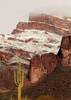
| partners | | It had been a little over four years since my last visit to Crucifix Canyon, and I still hadn't seen the bat cave, so that was our first destination today. We were the only people around when we started a little after sunrise and headed west down into the creek bed. I always forget just how rugged and scenic this area is, with spires, arches, recessions, and formations all around.
There were quite a few pools in the creek bed, and as we approached the section of the canyon that curves slightly to to the southeast, rifle shots echoed loudly down the canyon. It was hard to tell which direction they were coming from, but the shots continued periodically for a few hours. We had some fun scrambling though the massive boulders before the canyon opened up again, and the bat cave and the ladder eventually came into view up in the canyon wall.
The slope getting up to the cave didn't have many thorns to deal with, fortunately, but the grasses and brush made it tough to see exactly what we were stepping on. We could see the Salt River off to the west, but didn't try making our way over there. I expected the guano smell to hit us a lot sooner than it did...I guess the cave is big enough and open enough that the smell isn't as concentrated as I expected, because even when we were in the cave, it could've been a lot worse.
But the layer of guano on the ground was plenty thick, and the constant chirping of bats from the dark void above was an added reminder to keep our mouths closed when looking up  . I let ishamod trek ankle-deep through the guano to check out the ladder while I hung back and stood on rocks to avoid sinking in. The ladder has a lower metal section attached by rope to the bottom rung of the wooden section, and the whole thing is very rickety and shakes from top to bottom with any movement on the metal section...ishamod only went up a few steps despite my encouragement to retrieve the gold at the top . . I let ishamod trek ankle-deep through the guano to check out the ladder while I hung back and stood on rocks to avoid sinking in. The ladder has a lower metal section attached by rope to the bottom rung of the wooden section, and the whole thing is very rickety and shakes from top to bottom with any movement on the metal section...ishamod only went up a few steps despite my encouragement to retrieve the gold at the top .
Guano must be a lot more valuable than I thought, because it's hard to understand the economics of removing it from such a remote location. (If it's that valuable, ishamod had a fortune in his boots when he left the cave ). And what was the purpose of the ladder? Regardless, it was interesting to see it in person, though it's not a place I feel an urgent need to visit again--the cave it impressive but not a particularly pleasant place to spend any extended length of time, between the smell, the guano, and the fact that you'd never want to set stuff down or sit anywhere near it.
Ishamod paused to empty his boots, and we headed back down the slope and took a break in the shade of the creek bed to eat something before starting back, with rifle shots still echoing occasionally. On the hike out, we passed two hikers and eventually ventured out of the creek bed again to check out the double arches. Getting up there wasn't as brushy as I remembered from years ago, and it's a beautiful area.
Back near the trailhead, we stopped by the crucifix (does anyone know the story behind it?). There was a surprising amount of traffic near the FR80 gate--three or four vehicles came and went in the ~20 minutes we were there, including a vehicle that drove up the "government only" road and through the gate. After leaving the crucifix, we checked out the early part of the route up to Black Cross Butte...ishamod climbed up the narrow chute and explored up there a little, but we ended up taking the longer, clockwise route up to the saddle, where we could see Chalcedony Cave, then continued up to the butte. It was windy up there, but the views were great with the late the afternoon shadows.
[ youtube video ]
We ended up fitting a lot into a 10-hour day, though the pace was pretty leisurely with the rough terrain. But it was nice to finally see the bat cave and get back to the Superstitions for the first time this fall...a very enjoyable "Sunday service" in Crucifix Canyon . |
| | |
|
|
|
 Route Editor