|
| | | |
| |
|
| Hiking | 10.55 Miles |
3,121 AEG |
| | Hiking | 10.55 Miles | 9 Hrs 28 Mns | | 1.85 mph |
| 3,121 ft AEG | 3 Hrs 45 Mns Break | | | |
|
|
| |
| Linked |
|
none
[ show ]
| no linked trail guides |
| Partners |
|
none
[ show ]
| no partners | | Note: I found a great place to car camp 4.3 miles down the road from the Williams Lake trailhead. There was a stream with flowing water and it was about 50 feet from the main road. The noise from the flowing creek drowns out most of the road noise. Use this location to find this nice free campsite. 36.588861, -105.490356
Also note: my stats include going to the Williams lake lookout/sign, and Walter peak
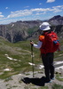
I arrived at the trailhead around 8 am. There were probably 6-10 cars in the parking lot by this time which was fewer than I expected for a Friday. I started walking down the road. Pretty soon I was near the Bavarian restaurant which looked closed and the ski resort, obviously also closed. The signs could have been better here because I found it a bit confusing how to get to the Williams Lake trail. I eventually found a sign that led me down a trail that eventually took me to a small wooden bridge. I crossed the bridge and continued toward Williams lake. There was a family of hikers that started just before me. They stopped to let me pass so I continued on. The trail was fairly well-maintained here, but there were some rocky areas and areas with a lot of tree roots sticking up. The tree cover ended up being very nice on the way back when it was much warmer. The temp felt like around 60 at this elevation. I took a water/breakfast break probably about halfway to the lake. I got to the Wheeler trail junction but decided to go the additional 1/4 mile or so down to the lake. I got to the sign and took a few nice photos of the lake. The nice family arrived just after me and offered to take my photo at the Williams lake sign. They were from Fort Worth, Texas and said they go to the lake every year. I took their photo and we chatted for a while. It was about 9.20 am now and I've already hiked 2.3 miles.
I headed back to the trail junction. There were several huge areas of broken rocks between the lake and the trail junction. I continued to the signed junction and made a right turn to continue on the trail up to Wheeler peak. I believe from this point it would be about 2.5 miles to the summit. The trail started off going through pines and there were a few switchbacks. There were some steep sections of trail that were slow going. I exited the treeline at somewhere around 11,500 feet elevation. From here, I knew I had another 1,600+ feet of elevation to go. There were some scattered trees, some grassy areas, and some rocky areas. The trail was maintained very well.
I continued up and crossed paths with a few hikers coming down. A few of them said it was extremely windy at the top. I was hoping that by the time I got up there the wind would die down a bit. I kept going up the trail at a steady pace. I think I took 1 or 2 water breaks the whole way up and just kept going as a comfortable steady pace. I didn't really feel like I needed a lot of water because it was cool but I remembered that it would be good to force myself to drink because I didn't want to get de-hydrated. Higher up there were no trees at all, some patches of grass, and many huge areas of rock of all different sizes. When I got close to the saddle, it started getting windier, so I put on my wind breaker. I eventually reached the saddle between Wheeler and Walter. The wind was very strong at this point, maybe 50 MPH winds. I saw a big rock tower that was probably built over the years at the saddle and then I saw the trail leading to Wheeler peak. At this point, I believe I only had another 0.2 miles to go.
I pushed on and got to the summit around 11:45 am. I met another nice family at the top with a baby and 2 dogs! I could not believe they brought a baby up here with these kinds of winds but it all worked out fine. The baby must have been well-protected from the wind. We all sat down with our backs against some rocks and that sheltered us from 80% of the wind. What a huge difference. The dogs were very playful. One of the dogs brought me a stick. I threw it a couple of times and the dog ran and brought it back to me. These dogs didn't seem to care much about the wind! I had part of my lunch and the family headed down toward Horseshoe lake where they came from. There were some playful chipmunks running around at the summit. They were probably just looking for some snacks. They got within about 6 feet of us or less!
I did a summit video, and then 4 others arrived at the summit. We talked for a bit. They were all locals and have done this summit many times. I was telling them about my trip, what I had done, and what I had planned. They told me about a 'secret' lake that not many knew about and also talked about other trails along the ridgeline. At the summit, there was an old cannon with a plaque. There was a huge metal cap on the end of the cannon that they said there was a registry inside, but none of us could unscrew the cap. It seemed to be welded or rusted on. Another guy insisted that they were able to open it years ago, but because of the weather and time, nobody could move this cap. My guess is the registry was taken out and the cap was sealed because this cannon was a piece of history.
I stayed on the peak for a total of 1.5 hours which was only possible because the rocks helped shelter us from the extreme wind. It was already after 1 pm at this point and I thought it would be a good idea to finish the hike. Another local told me it's recommended to get off the high ridge by 2 pm whether you see storm clouds or not. Apparently these storms can move in fast. I took the trail back down to the saddle and continued about 700 feet of trail up to a pole and a sign which marked Mt. Walter. The topo map had a 13,133 mark on the map which was 13 feet higher than Mt Walter so I decided to walk to it. Why the high point was not considered Mt. Walter is a mystery. There was no registry here, so I took a few photos and started to head down the trail, going down the same way I came up. On my way down I passed a few other hikers coming up. Some were only hiking part way.
The trail at times crossed a few rocky channels. In one of these areas I saw what I'm pretty sure was a marmot. I looked it up afterwards and found out that these are ground squirrels, not to be confused with ground hogs or beavers. It let me get pretty close, maybe within about 5 feet away, before it took off. I continued down to the trail junction going to the lake. I decided to take a break here because my feet were pretty worn out at this point. This was my 5th straight day of hiking and I knew I would be tired at this point.
After taking a water/snack break I continued heading down the Williams Lake trail. I struck up a conversation with a guy named Greg who was coming up. He said he was living in Taos but previously lived in Colorado. I was telling him about my plans to hike some 14ers and maybe some easier hikes in between in the Colorado Springs area. I told him I was on PeakBagger and he heard of the site before. Greg, if you read this trip report, drop me a line sometime!
I walked down to the bottom and went to check out the Bavarian restaurant which I noticed was closed. Then, I walked back to the trailhead, getting there around 5:30 pm. Considering all of the breaks and stops I took the entire day, I was satisfied with my time. I kept reminding myself that I was there to enjoy everything and it was not a race! ;-)
Stats:
-------
10.55 miles round trip
3,121 feet AEG
Strava moving time 5 hrs 42 mins
Strava elapsed time 9 hrs 28 mins
Driving to the trailhead:
---------------------------
You will definitely need high clearance to get to the trailhead parking.
The signs recommend 4x4.
I believe it is possible without 4x4 when the road is dry and in summer.
I had my 4x4 turned on once I got off the paved part.
I believe roughly the last 2 miles getting to the trailhead are dirt/gravel. |
| _____________________
Michael Williams
IT Professional
Rocky Point Vacation Rentals
Ocean Front Condo in Rocky Point, Sonora, Mexico
www.beachfrontmexico.us
 |
| | |
|
|
|
 Route Editor