|
| | | |
| |
|
| Canyoneering | 5.70 Miles |
2,600 AEG |
| | Canyoneering | 5.70 Miles | 10 Hrs | | 0.57 mph |
| 2,600 ft AEG | | | | |
|
|
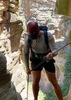
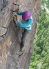
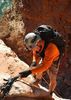
| | Intermediate Canyoneering - Difficult or dangerous; Tech Climb; rope reqd; descent anchor; exit technical; | | B - Up to light current; wading/swimming; possible wet/dry suit | | III - Normally requires most of a day |
| |
| Linked |
|
none
[ show ]
| no linked trail guides |
| Partners |
|
none
[ show ]
| no partners | | Wow! This canyon was amazing! Don't lead this with more than 5 people though, or you'll hate yourself (Why can't I say no?). The approach is somewhat taxing, but can be accomplished easily if you pace yourself. I suggest starting as early as possible, with a group of 7 we didn't reach our vehicles until 8:30. All the webbing as of this post were nice and new, although the rapide on east fork entrance is going to need to be replaced soon. Man that first drop is insane. I would highly recommend the east entrance, as it is 215 of almost entirely free-hanging. You drop through a chimney-like feature and then travel down quite a ways away from the wall. Wetsuits are really not needed at all. We did this in the beginning of January, and even the most clumsy person should only get wet up to mid-thigh or waist (and only twice at that). The final rap is a lot more vertical than the picture led me to believe, but by the time I descended it was already dark  I will be coming back again, as this really is the best canyon in the Supes that can be easily reached. It can be done quite efficiently with a 300, a 200, and a 150 foot section of rope. If you haven't been here, you need to do it at least once! I will be coming back again, as this really is the best canyon in the Supes that can be easily reached. It can be done quite efficiently with a 300, a 200, and a 150 foot section of rope. If you haven't been here, you need to do it at least once! |
| _____________________
| | |
|
|
|
 Route Editor