|
| | | |
| |
|
| Hiking | 6.50 Miles |
1,100 AEG |
| | Hiking | 6.50 Miles | | | |
| 1,100 ft AEG | | | | |
|
|
| |
| Linked |
|
none
[ show ]
| no linked trail guides |
| Partners |
|
[ show ]
| partners | | Planned this trip with SuperstitionGuy last Spring. He had been wanting to drive the old Tortilla Ranch road and revisit Miller's gravesite and LDM Jr. I had been wanting to do that hike for some time. With him lacking a 4WD vehicle and having a fondness for Jeeps, and me having a fondness for tagging along behind someone who knows where they're going, we happily cut a deal.
First, I'd like to confirm that everything said here about that road is true. You absolutely need a high clearance 4WD. And, even then it is only as good as it's driver. We took my Jeep, and after turning off the Apache Trail, I made it exactly as far as the very first obstacle. After a brief and somewhat reluctant attempt to climb over it, this conversation took place:
ME: "What's that smell?"
SUPERSTITIONGUY: "Your clutch burning."
ME: "You drive."
**Note to self: Cancel road trip to Crown King.
Most of the road is difficult but do-able, even by me. But, the parts that are bad are really bad and there's no way at all to avoid them. You may even need to have someone act as a spotter to direct you over some of the worst hazards. While I buckled myself in and held onto the roll bar, SuperstitionGuy forged ahead without missing a beat.
Heading out on the trail, he quickly located two of the Miller Mines and Miller's gravesite (GPS coordinates are N33*29.247" W111*17.202"). *Info from SuperstitionGuy: "The grave marker is an old mine car rail that was stuck upright in the dirt. Originally, it protruded out of the ground between three and four feet high, but someone has broken it off by twisting and bending it. Obviously, they did not know it was a grave marker." After building a cairn to better mark the site, we started toward the LDM Jr.
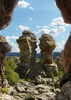
Getting there proved to be more of a challenge than we expected. The entire area was heavily overgrown. Much of the way the trail was obscured by dense vegetation and difficult to follow at times. The catclaw is pretty bad up there and we had to cut through a jungle of it to reach the mine, but we were careful and escaped with minimal bloodshed. The mine entrance faces the northwest and is within a large rock formation which stands out from the rest of the surrounding terrain. There's some careful climbing and scrambling involved to locate and enter the mine. The GPS readout here was N33*28.475", W111*16.565". Once inside, it looks more like a 2 room wind cave with a high ceiling and a couple of nice skylights. It doesn't appear that too many have visited recently, but the message on the wall would suggest at least one person had been there. We took some photos but didn't stay too long because the clock in the sky said we had to get moving. Our war on catclaw had cost us a lot of time and we ended up hiking out in darkness. The bright half moon provided much light and, except for being a bit chilly, it was a nice hike out. SuperstitionGuy drove us back out that killer road in the dark like it was nothing. I guess that's why he wears the cape! |
| _____________________
I'm at home in the wilderness... it's civilization I have problems with! ](https://hikearizona.com/dex2/images/smilies/eusa_wall.gif "Brick wall") |
| | |
|
|
|
 Route Editor


 From the spring we made our way through the catclaw back up to the JF trail. The JF trail is overgrown from the prior rains but you can follow it as long as you pay attention. We noticed several bear droppings along the JF trail. We hiked up to saddle and made our way over to the Lost Dutchman Mine Jr cliff. We hiked up and down a few times finding the cave and the alleged mine. Denny found a black-tailed rattlesnake in the bushes. I think he was wishing I would have found it first.