username
X
password
register
for free!
help
ArticlesGuidesRoutes
 
Photosets
 
 Comments
triplogs   photosets   labels comments more
Barks Lower Canyon Loop - 36 members in 128 triplogs have rated this an average 3.8 ( 1 to 5 best )
1, 2, 3, 4, 5 ... 7  Next
128 triplogs
login for filter options
Feb 26 2024
avatar

 Photos 3,883
 Triplogs 169

80 male
 Joined Mar 18 2012
 mesa,az
Barks Lower Canyon LoopPhoenix, AZ
Phoenix, AZ
Hiking avatar Feb 26 2024
jameslcox44Triplogs 169
Hiking4.25 Miles 848 AEG
Hiking4.25 Miles   4 Hrs      1.06 mph
848 ft AEG
 no routes
1st trip
Linked   none no linked trail guides
Partners none no partners
We talked about doing lower Bark's Canyon after seeing triplogs on HAZ. After many years of hiking, we finally made it to do this hike. We picked the perfect time with all the water in the canyon. The right amount of water too, as more water would made it more difficult to navigate.
wildflower observationwildflower observationwildflower observationwildflower observationwildflower observation
Wildflowers Observation None
We were seeing Mexican poppies springing up all along the way.
_____________________
 
Feb 25 2024
avatar

 Photos 268
 Triplogs 17

female
 Joined Mar 12 2021
 Seattle, WA
Roost Lone Tree Cave Dacite Lower Barks loop, AZ 
Roost Lone Tree Cave Dacite Lower Barks loop, AZ
 
Hiking avatar Feb 25 2024
rubywranglerTriplogs 17
Hiking10.00 Miles 2,500 AEG
Hiking10.00 Miles
2,500 ft AEG
 no routes
1st trip
Peralta trailhead was 75% full when I arrived at 7:15am. I attempted to make a beeline from the TH toilet to the Dons camp but should have just walked the road. There was an intermittent bootpath but it was pretty brushy; then it took me awhile to find a spot where I could cross over the wilderness boundary fence to get on lost goldmine. It was not the most efficient start!

I thought I had come down Carney Spring a few years ago but the trail didn't seem familiar so now I'm thinking I actually came down the next gully west. I remember a lot more brushy boulders. This trail was actually enjoyable. The whole loop was super fun and scenic, I love the pinnacles and rock formations up high in this part of the supes. Checked out the roost, had lunch at lone tree, checked out the cave, did some single-arm crab walking to get down the ridge... :lol:

I turned left on bluff spring and then right into lower barks. Almost immediately I ran out of water so I rolled the dice and scooped up some unfiltered stream water to sip (so far so good :) ) Lower barks was prettier than I expected with big rock shelves and nice pools. About 10 minutes from connecting to dutchman I was blissfully and obliviously rock-hopping down canyon and came within inches of stepping on a very angry rattlesnake. He reared back and rattled like crazy. I didn't slow down until I was 6-8 feet past him. I've seen a few rattlesnakes but can't remember ever being rattled at like that. I very nervously tiptoed the rest of the way downstream and was so relieved to get back on a trail!
  2 archives
Feb 14 2024
avatar

 Routes 255
 Photos 1,071
 Triplogs 245

68 male
 Joined Feb 10 2008
 Kent,wa
Barks Lower Canyon LoopPhoenix, AZ
Phoenix, AZ
Hiking avatar Feb 14 2024
fdv75Triplogs 245
Hiking8.25 Miles 1,786 AEG
Hiking8.25 Miles   6 Hrs   43 Mns   1.50 mph
1,786 ft AEG   1 Hour   13 Mns Break
 
1st trip
Linked   linked  
Partners none no partners
Route Scout Route Recorded  on Route Scout | Pop | Map | Popup | MapDEX
Lots of water crossings on the entire Lower Barks Canyon. Mainly hiking on rocks, boulder and slick rock. Very pretty. Manage to keep the feet dry, but just barely.
_____________________
  1 archive
Feb 17 2023
avatar

 Guides 110
 Routes 2,248
 Photos 8,982
 Triplogs 2,602

45 female
 Joined Dec 24 2007
 Ahwatukee, AZ
Barks Lower Canyon LoopPhoenix, AZ
Phoenix, AZ
Hiking avatar Feb 17 2023
LindaAnnTriplogs 2,602
Hiking4.74 Miles 889 AEG
Hiking4.74 Miles   3 Hrs   42 Mns   1.43 mph
889 ft AEG      23 Mns Break
 
Linked   none no linked trail guides
Partners partners
Tortoise_Hiker
Route Scout Route Recorded  on Route Scout | Pop | Map | Popup | MapDEX
Denny and I got to Peralta about 0845 and ran into @rayhuston , who was volunteering at the trailhead. Chatted with Ray for a few minutes in the cold breeze then we got started on Bluff Springs Trail. We to the Peralta rock, then backtracked and went down Lower Barks. Plenty of water, but nothing impeding progress. Some catclaw, which Denny attacked with clippers. A few amount of grass in places, which made footing somewhat difficult, but nothing terrible. Easy hike out on Dutchman. Fun day and conversation, and always great to hike with Denny.
 Flora
 Flora [ checklist ]
[ checklist ]  Saguaro
_____________________
Stop crying and just go do the hike.
 
Feb 17 2023
avatar

 Guides 1
 Routes 148
 Photos 9,928
 Triplogs 3,655

63 male
 Joined Apr 02 2005
 Mesa, AZ
Barks Lower Canyon LoopPhoenix, AZ
Phoenix, AZ
Hiking avatar Feb 17 2023
Tortoise_HikerTriplogs 3,655
Hiking4.74 Miles 889 AEG
Hiking4.74 Miles   3 Hrs   42 Mns   1.43 mph
889 ft AEG      23 Mns Break
 no routes
Linked   none no linked trail guides
Partners partners
LindaAnn
A nice little outing with Linda in the Supes! Got to chat with Ray at the trailhead too which was nice. He showed us proof he has been clearing trails with catclaw marks on his arms. Thanks Ray and great to see ya!
Linda and I took Bluff Spring Trail to the Peralta rock where we saw the only other hiker for the day.
Then we took Barks Canyon down to Dutchman Trail. Fun to explore this area when it has water running here and there. Dutchman Trail back to the truck went smoothly with a nice breeze and overcast. Great weather, hike, conversation, and company! 😁 Thanks Linda! Like HAZ, you rock!!
_____________________
Tortoise Hiking. Stop and smell the Petrichor.
 
Dec 25 2022
avatar

 Photos 8
 Triplogs 16

44 male
 Joined Jul 22 2005
 Chandler, AZ
Barks Lower Canyon LoopPhoenix, AZ
Phoenix, AZ
Hiking avatar Dec 25 2022
slackerTriplogs 16
Hiking4.25 Miles 848 AEG
Hiking4.25 Miles   5 Hrs      0.85 mph
848 ft AEG
 no routesno photosets
Linked   none no linked trail guides
Partners none no partners
Saw some big horned sheep, which was amazing, frogs and a good amount of pooled water.
The last part of the wash was severely over grown and very hard to navigate.
_____________________
 
Mar 27 2022
avatar

 Routes 181
 Photos 901
 Triplogs 259

50 female
 Joined Mar 09 2010
 Chandler, AZ
Barks Lower Canyon LoopPhoenix, AZ
Phoenix, AZ
Hiking avatar Mar 27 2022
azlaurieTriplogs 259
Hiking4.59 Miles 972 AEG
Hiking4.59 Miles   5 Hrs   24 Mns   1.38 mph
972 ft AEG   2 Hrs   4 Mns Break10 LBS Pack
 
1st trip
Linked   none no linked trail guides
Partners partners
dswitzer3
Route Scout Route Recorded  on Route Scout | Pop | Map | Popup | MapDEX
Don and I set out the Superstions for a relatively short hike. Saw a few backpackers returning on our way out. No one on the trail tho. We started at Cardiac Hill, which was about 600 feet in the first mile. Then, Lower Bark's Canyon, a.k.a. boulder hell. About 2 miles of huge and medium boulders. About 1/2 way I battled heat stress. We had to break every 15 minutes when we found any sort of shade. That was a challenge, but i did not die. At 90 degrees it feels like 190. Pls be careful out there peeps! Flowers were beautiful and we saw some cool rock formations. Another successful hike for me and my love. ♥
_____________________
♥ Timing is Everything ♥
 
Feb 10 2022
avatar

 Guides 110
 Routes 2,248
 Photos 8,982
 Triplogs 2,602

45 female
 Joined Dec 24 2007
 Ahwatukee, AZ
Barks Lower Canyon LoopPhoenix, AZ
Phoenix, AZ
Hiking avatar Feb 10 2022
LindaAnnTriplogs 2,602
Hiking8.17 Miles 1,396 AEG
Hiking8.17 Miles   4 Hrs   28 Mns   1.87 mph
1,396 ft AEG      6 Mns Break
 
Partners partners
Tortoise_Hiker
Route Scout Route Recorded  on Route Scout | Pop | Map | Popup | MapDEX
Denny invited me to join him today on a Bluff Springs/Lower Barks hike. I had thought including Lower Barks would add a half mile over just doing a Bluff out and back. Turns out, it’s a extra mile. Oops.

Anyway, we started up Bluff Springs a little before 0630, using lights for the first few minutes. Very windy, but not cold. Went all the way to the Dutchman jct, then turned around. There was a little bit of water, but not much. Saw one deer. Also passed by three backpackers who had set up their tents about two inches off the side of the trail.

Tirned onto Lower Barks and followed that down. There was some water, but not enough to force many detours. Mostly a fun boulder hop down. I was glad to be wearing grippy shoes. There was a little more vegetation as we neared Dutchman, and I couldn’t see where I was placing my feet in the tall grass, so I just crossed my fingers and hoped the snakes were all still asleep. Took a much better route than a year ago.

Once on Dutchman, it was a quick mile back to the trailhead. Other than the three backpackers, I think the only other people we saw were two hikers on Dutchman. As always, a fun hike with Denny!
wildflower observationwildflower observationwildflower observationwildflower observationwildflower observation
Wildflowers Observation Isolated

water 1 out of 5water less than maxwater less than maxwater less than max Bark at Dutchman Crossing Pools to trickle Pools to trickle
Large pool of water. Needs to be filtered.
_____________________
Stop crying and just go do the hike.
 
Feb 10 2022
avatar

 Guides 1
 Routes 148
 Photos 9,928
 Triplogs 3,655

63 male
 Joined Apr 02 2005
 Mesa, AZ
Barks Lower Canyon LoopPhoenix, AZ
Phoenix, AZ
Hiking avatar Feb 10 2022
Tortoise_HikerTriplogs 3,655
Hiking8.17 Miles 1,396 AEG
Hiking8.17 Miles   4 Hrs   28 Mns   1.87 mph
1,396 ft AEG      6 Mns Break
 no routes
Partners partners
LindaAnn
An early start albeit windy worked out nicely. Linda joined me for a comfortable pace and a nice sort of loop. Went out Bluff spring to the end. Came back as far as lower Barks and took it down to Dutchman and back to the cars. It’s been awhile since I’ve been on Bluff Spring and Lower Barks too! Nice views on Bluff and Lower Barks is just a cool area! Not as much water as I thought there would be but still cool! Saw one deer today. Only people we saw on Bluff were camped practically on trail. Then saw one couple on Dutchman. Very enjoyable outing! Thanks Linda! Like HAZ, you rock!
 Named place
 Named place [ checklist ]
[ checklist ]  Weavers Needle
wildflower observationwildflower observationwildflower observationwildflower observationwildflower observation
Wildflowers Observation Isolated
_____________________
Tortoise Hiking. Stop and smell the Petrichor.
 
Jan 28 2021
avatar

 Guides 110
 Routes 2,248
 Photos 8,982
 Triplogs 2,602

45 female
 Joined Dec 24 2007
 Ahwatukee, AZ
Bluff Spring Mountain SummitPhoenix, AZ
Phoenix, AZ
Hiking avatar Jan 28 2021
LindaAnnTriplogs 2,602
Hiking10.23 Miles 2,367 AEG
Hiking10.23 Miles   8 Hrs   49 Mns   1.34 mph
2,367 ft AEG   1 Hour   11 Mns Break
 
Partners partners
Daytripper
Route Scout Route Recorded  on Route Scout | Pop | Map | Popup | MapDEX
Tom was graciously willing to let me join him on his annual trek to Bluff Spring Mountain. We met at Peralta around 0800 and headed up Bluff Springs Trail. Quite breezy to start, with cool temps. My first time seeing the burn damage in this area. Also got to see the Peralta Rock, which I’d never known about!

The off trail up to the summit was quite steep in places, but we were able to find dry rock most of the way. The softer soil from the rain/snow earlier this week helped with footing too. Still a little bit of snow at the summit, but it’ll be gone soon. Very breezy, so we sat just below the top where we were shielded from the wind. After a snack break, we headed back down.

Tom’s back was not enjoying the descent, so once back on trail, we opted to return on Bluff Springs Trail, rather than loop around on Dutchman. No breeze down low, so it felt warm at times. At Barks Canyon, we decided to head down that rather than stay on the trail. With all the water, finding a good route was challenging at times. Plenty of boulder hopping, dodging catclaw, and trying to stay on dry rock. Progress was slow, but we eventually made it to Dutchman. At one point, we were saying “just another half mile” for what seemed like two miles :lol: The catclaw was the biggest nuisance, without that, it would have been much easier, and seeing all the water was very nice.

Once on Dutchman, it was an easy mile back to the trailhead. Saw two deer, a squirrel, and lots of bones. Very nice day, thanks, Tom, for letting me join you on this one!
 Flora
 Flora [ checklist ]
[ checklist ]  Saguaro
_____________________
Stop crying and just go do the hike.
 
Jan 28 2021
avatar

 Guides 7
 Routes 187
 Photos 2,318
 Triplogs 909

74 male
 Joined Dec 10 2016
 Gold Canyon
Bluff Spring Mountain SummitPhoenix, AZ
Phoenix, AZ
Hiking avatar Jan 28 2021
DaytripperTriplogs 909
Hiking10.23 Miles 2,906 AEG
Hiking10.23 Miles
2,906 ft AEG20 LBS Pack
 
For the cliff note version of this hike see the triplog by @LindaAnn for the novelette continue reading. Decided to make my annual January trek to Bluff Spring Mountain Summit, delighted and lucky to have a strong hiker like Linda accompany me . Peralta Road washboarding had increased since my last trip out to Peralta Trailhead but some grading took place while we were hiking so on the way out the washes were smoothed out. Parking lot was not very full about 0800. There was a cool breeze at the start which was intermittent all day, later some sun appeared and temperatures moderated. Bluff Springs Trail provided for a quick warm up, while viewing the remains of snow in Peralta Canyon more so on the west side, surprised not to see running water in the creek. Lots of solitude today, I think we saw a total of 7 other hikers today. Encountered flowing water in Bark’s canyon , splashed some on the Peralta rock for contrast when passing by. After passing the Terrapin junction we went up the hill where the Williams Camp was located , didn’t find any remnants today, from near there the ascent up the west face of Bluff Spring Mountain began. This was part of the burn area , so there was less vegetation than usual to deal with, the ground being softened by rain actually improved the footing, noted the last person up this way left a paltry amount of cairns :D Always nice views from the summit with the usual suspects visible, weavers needle, terrapin trail, black top Mesa, Battleship, Canyon Lake etc. while at the summit we dropped down a bit to the north to be out of the wind. We observed a helicopter going in and out of East Boulder Canyon while dusting off a small amount of soot collected. I entered our names into the register, the nice pictures of Johnr1 left by @tibber are still there ,placed all back in the ammo can which I returned to the summit cairn. After enjoying the views and snacks we proceeded down and across the mountain to the beginning of the Ely Anderson trail. On the way we spotted the bushy white tails of two cous deers that didn’t want to stop and pose for us today. Passed by the low wall at the top of Ely Anderson and began to descend nicely down the well cairned route. The hike was going along normally until it wasn’t. Intermittently I have problems stemming from a herniated lumbar disc , then today without any inciting event I began to notice about a third of the way down a not particularly painful but disabling spasm in my lower back. This began to cause difficulty with walking and balance which slowed my pace until I had to make a couple of stops. Not funny at the time but was actually having trouble maintaining balance sitting on a rock. Took a break at the Dutchman , Bluff Spring junction to figure out the next step. I was concerned I was making Linda a bit nervous, after a few minutes we decided to head back on Bluff Spring Trail, so I rallied enough to get back to a decent pace , possibly due to now being on a slight uphill grade , strap adjustments made on the pack or just fear of losing my pack carrying privileges :oops: as we had been engaged in several minutes of friendly repetitive banter about one subject , Linda “let me carry your pack” me “no” . Fortunately by time we reached Bark’s saddle I was feeling almost normal. Then I suggested we head over to Dutchman Trail via Lower Barks Canyon, the weather was nice , wanted to take advantage of the limited time you can do this and enjoy the sound of running water. Apparently I had forgotten how time consuming this route can be when trying to keep your feet dry ,climbing over slick boulders and avoiding vegetation. A pleasant scene it was with the large pools of water and surrounding cliffs. Near one pool we passed by a sandy area with some scattered bones still identifiable as formerly an intact deer the biggest quantity concentrated by a large Boulder with a dug out area underneath, someone 🤪 
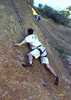
decided to start crawling under it , all I heard was “lots of bones in here” and that was my cue to exit, fortunately we didn’t meet the bone collector. Once your shoes get wet the slick boulders and smooth rock provided ice like traction allowing us ,without practice ,to perform a synchronized slip and fall from different boulders. As the canyon opens up and becomes less steep on approaching the basin don’t fool yourself that your almost done as the vicious vegetation takes over without body armor you might consider the canyon choked off. One particular pool about 40 feet long and 2 feet deep had too much vegetation to circumvent the edges, so we decided not to wade through and entered the jungle of catclaw. Two lessons ,a hiking pole makes a poor machete and when you thrash through 50 feet of vegetation in 10 minutes route scout counts it as a break :( . Hope resurfaced as Linda now leading took us through game trails toward Barkley Basin and by now the water had disappeared, was now thinking the sound of running water may be over rated. In an additional stroke of luck the mine above the left side of the canyon wasn’t visible until looking back up the canyon now so no one was tempted to go visit it , at least I dodged that one :D . A high five celebration on reaching Dutchman Trail, now feeling like we were on an interstate we practically ran the mile back to Peralta TH. Great day to be in the wilderness with a great partner but those off trail adventures can be tiresome.

water 1 out of 5water 2 out of 5water 3 out of 5water less than max Barks Canyon Medium flow Medium flow

_____________________
Navy31 Army13
 
May 30 2020
avatar

 Routes 174
 Photos 471
 Triplogs 184

51 male
 Joined Mar 16 2019
 Phoenix
Barks Lower Canyon LoopPhoenix, AZ
Phoenix, AZ
Hiking avatar May 30 2020
AugustWestTriplogs 184
Hiking6.18 Miles 1,271 AEG
Hiking6.18 Miles   3 Hrs   6 Mns   2.08 mph
1,271 ft AEG      8 Mns Break
 
no photosets
1st trip
Linked   none no linked trail guides
Partners none no partners
Route Scout Route Recorded  on Route Scout | Pop | Map | Popup | MapDEX
I hadn't been in the Western Supe's for over a year. The trail running shoe brand that has been my go to was discontinued so this was my inaugural hike in the new brand. The weather was also primed for my first Sonoran Desert hike of the summer with temps at 8 AM around 100.

The shoes were doing great so after the Lower Barks turnoff I continued to the Terrapin junction.

This is a pretty trail and I only saw one person at the top of Cardiac Hill the whole day. I think the most interesting portion of this loop is the lower Barks Canyon portion which is easy going without any real water in the creek.I just followed the course of where the water would flow and it was easy peasy.

The closer to Dutchman's at the bottom of the canyon the greater the frequency of pools, but filtering this water would be an act of desperation.

It was about 109 back at the TH with maybe 4-5 cars parked. Mountain Rescue helo and Superstition District Fire and Rescue were running operations in Peralta Canyon.
wildflower observationwildflower observationwildflower observationwildflower observationwildflower observation
Wildflowers Observation Isolated
Some Saguaro blooms and maybe 6 Century Plants flowering.

water 1 out of 5water less than maxwater less than maxwater less than max Bark at Dutchman Crossing Pools to trickle Pools to trickle
Nasty stagnant pools

dry Barks Canyon Dry Dry
water report recorded in the field on our app Route Scout
_____________________
Wildflower seed in the sand and wind
May the four winds blow you home again
 
Feb 16 2020
avatar

 Guides 8
 Routes 70
 Photos 3,208
 Triplogs 273

59 male
 Joined Oct 07 2017
 Chandler, AZ
Barks Lower Canyon LoopPhoenix, AZ
Phoenix, AZ
Hiking avatar Feb 16 2020
YoderTriplogs 273
Hiking4.30 Miles 1,040 AEG
Hiking4.30 Miles   3 Hrs   5 Mns   1.69 mph
1,040 ft AEG      32 Mns Break10 LBS Pack
 no routes
1st trip
Linked   none no linked trail guides
Partners none no partners
Hike was what was expected. Not really big on rock hopping. Water was flowing, and some nice sections.
_____________________
J. Yoder
 
Jan 31 2020
avatar

 Guides 7
 Routes 73
 Photos 14,456
 Triplogs 628

62 female
 Joined Aug 19 2011
 Scottsdale, AZ
Barking Miners Lollipop, AZ 
Barking Miners Lollipop, AZ
 
Hiking avatar Jan 31 2020
outdoor_loverTriplogs 628
Hiking12.55 Miles 1,950 AEG
Hiking12.55 Miles
1,950 ft AEG
1st trip
Grab a chair and a cup of coffee, it's a novel. :sweat: Here's the short version. I came, I conquered, lost some blood and tried to fill up a Memory Card.

A Hybrid of 2 Loops. I've never done the Miners Needle Loop or Lower Barks Canyon, so I thought I'd combine them. The only section of the Dutchman Trail I've not done, is from the Whiskey Springs Junction down to Bluff Springs. So I was going to tick that off as well. I have done the Bluff Springs Trail so eliminating that was no loss. It was a great plan that had a couple of different options depending on my speed and timing. I was also due, and ready, for some Off-Trail stuff. If the knees want to whine, I'll give them something to truly whine about. : rambo : Considering what I ended up doing, half the trip was pretty much non-tech Canyoneering. :D

Got to the Peralta TH right at sunrise and there were already 10 cars in the lot. There was a breeze and I knew I'd be in the shade for a bit, so I kept my hooded jacket on for the start. I went CCW and I always enjoy Barkley Basin in the morning light. Speaking of light, I was doing this stretch for the first time without a 40 lb pack. It was rather refreshing to be carrying less than half of that. By the time I hit the Coffee Flat Junction, I was ready to shed the jacket. Even though the breeze had gotten stiffer, I was too warm in the sun. There was an older couple taking a snack break there. We exchanged hellos and I mentioned that I was going to remove a layer. The woman told me how stupid I was for even starting with a jacket on. I hadn't been there 90 seconds. :-s
That's ok. I got the last laugh later, at noon, when the winds were higher and I ran into them again. The woman had her jacket on and was still cold. She must be done with Menopause. I was in shorts and short sleeves and doing just fine. :sl:

When I descended on the Dutchman from the Whiskey Junction, I was seeing that little valley for the 1st time. I wish I could have seen it before the fire. I noted how discriminatory the fire was in places. A whole hill burned, but a green saguaro or a green patch of prickly pear on the same hill looked almost untouched, with a completely charred bush right next to them. I took some photos of the disparity just to remember the sights by. The grass is greening up nicely in there already though.

I took a snack break at the Dutchman/Bluff Junction. Went up the Creek a little ways so I didn't have people right on top of me while I was chillin'. The moss in there is pretty cool. After my break I got on Bluff Springs headed for Terrapin. I have to mention, that from Sunrise until just before the Terrapin Junction, it was beautiful blue skies and not a cloud in sight. Just wind. As I neared the Junction, I started to see a cloud rising up from behind Bluff Spring Mountain. It was kinda weird and it got even more weird. The wind started to quit and the cloud became 3 clouds, but it looked like someone was using a blanket to send smoke signals. There will be a Photo in my set for a visual. @vanman saw the same thing over in Chuparosa Canyon and mentioned it as well. From then on, the skies were pretty cool at times.

I arrived at the Junction. In Fritzski's Description of the Lower Barks Canyon Loop, his last couple of paragraphs mention a "mid Barks" section. I made good time to this point, so I decided to do it. I followed his Description and realized later that he made a slight mistake. When you drop into the drainage at the Intersection, that drainage technically isn't Barks. In order to get into the Barks drainage, you would have to go up the Terrapin a bit. The drainage he refers to is a side drainage that eventually dumps into Barks. But his Description of this side drainage was spot on and maybe even a bit conservative. :sweat: Less than 1000 feet in this drainage and his descriptive wording of "a bit more rugged" slaps you right in the face. And then you see the "beautiful, but dense thicket of trees." Well, they were beautiful from the top of the Waterfall at least. :sweat: At the top of the waterfall, I'm faced with a fairly sketchy 10+ foot slide to get down it and it's one of the few times where I would have liked to have had someone else along. I had some hesitation going. If I screwed up, it was going to hurt. But I went for it, but made sure I took the pack off. Felt pretty good to be successful. It was short-lived. What I couldn't see, was that once you got down from there, walked down the cascade a bit, there was another drop of at least 15 feet and it was straight down. I looked for options and there was one that MIGHT get me down. I couldn't see it very well because of the brush. But I had to try. I'm still in shorts and short sleeves and I plowed in anyways. :o The brush and trees were ridiculous to try to get through, but somehow I did it and was able to drop into the drainage. Between that point and where the drainage drops into Barks, I guess I donated about 1/2 Pint of blood. Those beautiful trees? They sucked and where their limbs didn't actually touch the ground, the catclaw rose up to meet them. A Machete would have been good here. It was an all out fight to get down to Barks. Finally got there and the brush eased up, a little. By the time I got to where Bluff Springs and Lower Barks merge, I was sufficiently shredded and bloody.

The merger of Barks and Bluff Springs Trail is always so pretty. Somehow, I missed the Peralta Rock in there though. After what I had just done, it was time for a break and a late lunch. I was joined by a Canyon Wren who was fishing for his lunch as well. I had never seen that behavior and watched him for quite awhile while I took some photos. He was behaving more like a Heron, than a Wren, and was quite successful. In spite of my battles in Mid Barks, I still had plenty of daylight and energy, so Lower Barks was still a go. With the exception of the last 1/4 mile, Lower was a piece of cake compared to Mid. I tried to always follow the Water, so I was zigzagging a bit. There were times where I could have gone around a few drops, but I opted to downclimb, since I thought I might be a bit rusty. Plus it was less bushwacking. It was pretty fun. I loved all that water and the reflections were pretty cool as well. It took me a bit longer than I thought it would and the last quarter mile took even longer. The Creek butted up against a cliff and was full so I had to hike up in the dry zone. But the dry zone had 3 foot tall grass with boulders underneath, so it was slightly treacherous because you couldn't see where you were stepping. Tread carefully or break an Ankle. And there was a little more bloodshed as well. :sweat: It was interesting how the Geology changed suddenly towards the end. Instead of smooth boulders, it became that confetti colored brittle rock like you see in the Mazzies.

Fritzski says that it will open up and follow the sandy wash back to the Dutchman. I hit sand about 20 feet before the Dutchman. I think things have changed since 2002. :lol: By the time I got there, the Golden Hour was almost over and I was feeling pressed to get up the trail before it got dark. I must have hit a second wind, because I made the top before Sunset even started. I took a break up there and enjoyed the light which ended up turning into a pretty nice sunset. While I was shooting the sunset, a Great-horned Owl was calling from Peralta Canyon. What a gorgeous ending to a great day. I hit the car right at dark and there were still about 10 cars. It's amazing, I'm betting that lot was full all day, but I saw no more than a dozen people. I must be doing something right. :lol:

Photos... I'll at least say that I tried to cut them down to a reasonable number. There was so much going on with this Hike!
wildflower observationwildflower observationwildflower observationwildflower observationwildflower observation
Wildflowers Observation Isolated
One Fairy Duster and a couple of bushes in Lower Barks.

dry Bark at Dutchman Crossing Dry Dry
Dry at the actual Crossing, but Light Flow and Pools to Trickle less than 100 feet up Canyon. Intermittently going underground in spots.

water 1 out of 5water 2 out of 5water less than maxwater less than max Barks Canyon Light flow Light flow
Mid Canyon is Light Flow to Trickle with Pools. Lower Canyon is Light Flow to Trickle with Pools, but water goes underground for stretches as well.

water 1 out of 5water 2 out of 5water less than maxwater less than max Crystal Spring Quart per minute Quart per minute

water 1 out of 5water less than maxwater less than maxwater less than max Miners Canyon Pools to trickle Pools to trickle
_____________________
Life is not a journey to the grave with the intention of arriving safely in a pretty & well preserved body, but rather to skid in broadside, totally worn out & proclaiming, "Wow What a Ride!"
 
Jan 28 2020
avatar

 Guides 7
 Routes 187
 Photos 2,318
 Triplogs 909

74 male
 Joined Dec 10 2016
 Gold Canyon
Barks Lower Canyon LoopPhoenix, AZ
Phoenix, AZ
Hiking avatar Jan 28 2020
DaytripperTriplogs 909
Hiking5.10 Miles 960 AEG
Hiking5.10 Miles   4 Hrs   40 Mns   1.09 mph
960 ft AEG17 LBS Pack
 no routes
1st trip
Partners none no partners
This loop requires as much time canyoneering as hiking, slow going down this scenic canyon due to watching foot placement and frequent picture taking. Was stymied about 3 to 4 weeks ago due to the volume of water here. Less water made for easier getting around the pools but still enough to make it interesting. Intermittently hearing the sounds of running water was also nice, may not last too long unless more rain is coming. Peralta road continues to be graded and getting smoother, lot was 1/2 full when I left and full on my return, presumed most headed up Peralta trail. The volunteer ranger thought there was a bighorn on the west side of Peralta canyon, I checked as I was ascending Bluff Spring Trail but never saw one. Met no one else on this trail or in the canyon and actually only passed 2 hikers on Dutchman trail on the return. Once the canyon widened and the smooth rock vanished the grasses and vegetation increased, followed a couple of game trails that resulted in more bushwhacking and backtracking finally emerging on Dutchman 104.
 Culture
 Culture [ checklist ]
[ checklist ]  Ghost?

water 1 out of 5water less than maxwater less than maxwater less than max Bark at Dutchman Crossing Pools to trickle Pools to trickle

water 1 out of 5water 2 out of 5water less than maxwater less than max Barks Canyon Light flow Light flow

water 1 out of 5water 2 out of 5water less than maxwater less than max Peralta Creek at #102 Crossing Light flow Light flow
_____________________
Navy31 Army13
 
Mar 16 2019
avatar

 Photos 6
 Triplogs 6

38 male
 Joined Feb 07 2017
 Phoenix
Barks Lower Canyon LoopPhoenix, AZ
Phoenix, AZ
Hiking avatar Mar 16 2019
expphotoTriplogs 6
Hiking3.35 Miles 843 AEG
Hiking3.35 Miles   3 Hrs   14 Mns   1.05 mph
843 ft AEG      3 Mns Break
 no routesno photosets
1st trip
Linked   none no linked trail guides
Partners none no partners
Very pretty. With heavy water flow, can be hard to follow the loop. Highly recommend though.
wildflower observationwildflower observationwildflower observationwildflower observationwildflower observation
Wildflowers Observation Moderate
_____________________
 
Mar 03 2019
avatar

 Guides 3
 Routes 25
 Photos 2,216
 Triplogs 237

63 male
 Joined Apr 22 2012
 Fountain Hills,
Barks Lower Canyon LoopPhoenix, AZ
Phoenix, AZ
Hiking avatar Mar 03 2019
KBKBTriplogs 237
Hiking4.50 Miles 900 AEG
Hiking4.50 Miles   5 Hrs   10 Mns   1.10 mph
900 ft AEG   1 Hour   4 Mns Break24 LBS Pack
 
1st trip
Partners none no partners
On Sunday, Marilyn, Nick, and I hiked the Barks Lower Canyon Loop. The route is to take Bluff Springs #235 and then turn south at the first intersection with Barks Canyon. Dutchman Trail #104 is used to return to the trailhead.

Barks Canyon still had a decent amount of flowing water. We hiked through water, but also did some rock hopping as well as the occasional down-climb. The deepest water that I hiked through came to mid-thigh, though it would have been easy to take other paths which would have been deeper. There were a few pools which would have been swimmers had we gone that way. For the most part, route finding was easy. We mostly stayed in the channel of flowing water, but occasionally had to get out to avoid some of the really deep pools.

We all had a lot of fun on this hike.
_____________________
  1 archive
Mar 22 2017
avatar

 Routes 17
 Photos 485
 Triplogs 510

77 male
 Joined Jan 07 2010
 Chandler, AZ
Barks Lower Canyon LoopPhoenix, AZ
Phoenix, AZ
Hiking avatar Mar 22 2017
Mike_FelsTriplogs 510
Hiking9.10 Miles 2,114 AEG
Hiking9.10 Miles   5 Hrs   40 Mns   2.01 mph
2,114 ft AEG   1 Hour   8 Mns Break
 no routesno photosets
1st trip
Partners none no partners
I figured today might be just about the end of the hiking season for the Supes. Tomorrow would have been better, if there isn't much rain, but I had a prior engagement scheduled.

I hit the trail at 6:00am and didn't have an actual route in mind. I started on the Dutchman's trail then cut across on the Don's trail to the Bluff Spring trail. Then took the Cave trail Up to Weaver's Overlook. On other hikes I had noticed a trail heading east off the Weaver's Overlook trail. So I figured what the heck... I should have had a GPS route to follow, but I assumed it would lead to Barks Canyon and Bluff Springs trail.

All went well for just under a mile. Then any sign of a trail disappeared along with any cairns. I was in a stream bed and figured it had to be a tributary to Barks. The last half mile was so full of boulders, cat's claw, holly and other vegetation a half mile took over an hour of fighting my way through. I finally made it to Barks and then the Bluff Spring trail.

The wildflowers were fantastic. Every color of the rainbow. Saw a gila monster. Until about the last mile I never saw another human.
_____________________
 
Feb 06 2017
avatar

 Photos 2,699
 Triplogs 240

female
 Joined Oct 31 2007
 Middle-of-Nowher
Barks Lower Canyon LoopPhoenix, AZ
Phoenix, AZ
Hiking avatar Feb 06 2017
snakemarksTriplogs 240
Hiking5.00 Miles 900 AEG
Hiking5.00 Miles
900 ft AEG
 no routes
Linked   none no linked trail guides
Partners none no partners
_____________________
I'm at home in the wilderness... it's civilization I have problems with! ](*,)
  1 archive
Jan 02 2017
avatar

 Photos 39
 Triplogs 2

male
 Joined Nov 27 2006
 Mesa, AZ
Barks Lower Canyon LoopPhoenix, AZ
Phoenix, AZ
Hiking avatar Jan 02 2017
stonerTriplogs 2
Hiking4.00 Miles 900 AEG
Hiking4.00 Miles
900 ft AEG
 no routes
1st trip
Linked   none no linked trail guides
Partners none no partners
Made the loop with no navigational issues thanks to the route I downloaded on my GPS. The description is sufficient to complete the hike as there really isn't any way to get off track but having the route on the GPS made me less anxious about missing the intersection with the Dutchman trail on the way out of the creek bed.

We finished the loop in roughly 4 hours with some minor scrapes and bruises from the rock hopping/bushwacking. The water level and flow were really high with the recent rain which made the canyon more beautiful but also far more difficult to navigate. My 15 yr old was in heaven but my wife may never go off trail with me again. :lol: To be fair, the rock hopping was far easier for my son and I that are both 6'4" - at 5'2" my wife had a harder time using the same route as us and ended up with a lot of water in her shoes.

Looking forward to doing this again at some point when there is less water.
_____________________
  1 archive
average hiking speed 1.45 mph
1, 2, 3, 4, 5 ... 7  Next

WARNING! Hiking and outdoor related sports can be dangerous. Be responsible and prepare for the trip. Study the area you are entering and plan accordingly. Dress for the current and unexpected weather changes. Take plenty of water. Never go alone. Make an itinerary with your plan(s), route(s), destination(s) and expected return time. Give your itinerary to trusted family and/or friends.

helpcommentissue

end of page marker