I've been itching for a hike and a friend needed a ride up to Prescott; we figured it was a good opportunity to take care of both needs. While the weather forecast wasn't optimal, we decided to make a go for it anyway - heading up and out of the valley ahead of rush hour with clouds overhead. Reviewed the radar before leaving the valley and it looked like the storm activity would be moving from south to north - the radar forecast looked like we'd be in the clear for the morning...but might get hit in the afternoon.
After an uneventful drive accompanied by a few brief sprinkles on our way out of the valley, we arrived at the trailhead around 8:30 with clouds overhead, finding a surprising number (7!) of vehicles there for a weekday. We got our gear together and headed across the road to pick up the trail. It was obvious from the beginning that I might be dawdling often on my way up, as wildflowers lined the trail on either side.  Count yourself forewarned about the photoset Count yourself forewarned about the photoset 
The the trail starts off heading through an open pine forest with views of Granite Mountain. After about a half a mile, we came to another large trail sign and register. We stopped for a quick flip through of the trail register, signed in, and continued on our way. The pines started disappearing, to be replaced with desert scrub vegetation - we were glad for the cloud cover as we continued to gain elevation. Soon enough, we hit Blair Pass and a gate - we turned right to start our ascent on the nicely graded switchbacks.
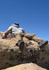
At the top of the switchbacks, we made a very short detour to take in the views from the saddle before continuing on towards the overlook point. As we were contouring around towards the overlook, it started sprinkling. With the sprinkles getting heavier when we hit the granite slab area of the overlook, we stopped for a brief break to grab a snack (and to quickly check the weather radar). With the humidity in the air and the raindrops falling around us, visibility was reduced, but the views were still enjoyable.
After our short break, we packed up and started heading back down - not too long after we started our way back, the sprinkles stopped. We really lucked out with the weather - it wasn't too windy on top, and we managed to miss the isolated downpours that seemed to hit the nearby Prescott area. The trip back to the car was uneventful, and the parking area had cleared out save for one other vehicle when we got back.
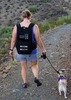
Other people: a handful of others and a pup seen on trail, all headed outbound while we were heading up.
Wildlife: scared up a few desert cottontails, a bunch of lizards, along with several beetles and plenty of birds - most of which were not captured by photos. |
 Route Editor


 Count yourself forewarned about the photoset