|
| | | White Mountains Wander I, AZ | | | |
|
|
White Mountains Wander I, AZ
| | |
| |
|
| Hiking | 10.50 Miles |
2,110 AEG |
| | Hiking | 10.50 Miles | | | |
| 2,110 ft AEG | | | | |
|
|
| |
| Partners |
|
none
[ show ]
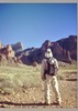
| no partners | | I decided to head to the White Mountains for a couple of days of hiking various peaks. On day one I went to:
* Antelope Mountain
* Wahl Knoll
* Pat Knoll
* Big Lake Knoll
These hikes started from different places, and there was a good bit of driving going from peak-to-peak.
Antelope Mountain
This one reminded of hiking to Greens Peak, which isn't too far away.
I hiked up and down forest roads, and views were nice the entire way. At one point I crossed into the State Land Trust, but I had my permit so I was legal.
There are not many trees at the top, so views of the area are quite expansive.
Wahl Knoll
At an elevation of 9,768', Wahl Knoll is the 26th highest peak in AZ. As a frame of reference, it is 9' higher than Chiricahua Peak.
I parked on a forest road, and more or less bushwhacked my way to the summit. There is a jeep road that goes to the summit from the west, which would be an easier way up that the route that I took.
Views at the summit are nice, and there are a number of entries in the log book at the summit, so people seem to come up here frequently.
Pat Knoll
Pat Knoll was the former site of a fire lookout many, many years ago. I have seen the lookout described as a "crow's nest", which implies that it was built in a tree instead of being a standalone structure.
Here is an anecdote that I saw about the Pat Knoll Lookout:
May 25, 1917: "About eleven o'clock on the morning of May 16, a big smoke was sighted from the Supervisor's office in Springerville, Arizona. At nearly the same time the Pat Knoll Lookout, Escudilla Lookout and the big Lake Lookout Stations reported a fire to the Supervisor's office over the phone. It was discovered the fire was only a short distance from the Pat Knoll Lookout Station, so Mr. Ellis Wiltbank, the lookout, was instructed to go at once. As Rangers Swapp and Rencher were in the office at the time of the discovery, they, with Administrative Assistant Billingslea started immediately. In two hours they arrived to find several cattlemen and sheep men already fighting it. After burning 100 acres the fire was put under control.
The fire was started by a Mexican sheepherder who had built his camp fire in some heavy bunch grass. He was arrested by the Forest officers above mentioned and brought to Springerville and they then took him to St. Johns, Arizone, and his trial was held the next day, May 17, and a fine of $25.00 was imposed." (The Copper Era and Morenci Leader)
To get there, I parked my truck on a forest road and walked mostly through open country to get to the summit.
Big Lake Knoll
I started from the Indian Springs TH, and took the Indian Springs Trail to a spur trail that goes to the summit of Big Lake Knoll. I returned the way that I came.
There used to be a fire lookout on Big Lake Know, but the lookout was overrun by flames and was destroyed by the Wallow Fire on June 3, 2011.
The views were nice up there, and I was glad that I made the hike.
Synopsis
I thought that Antelope Mountain was the best of the bunch, but they all are worth checking out if you are in the area. There were pockets of yellow aspen leaves here and there, which was an added bonus.
The mileage and AEG for these 4 summits are below. Stats above are the sum of these 4.
Antelope Mountain: 4.7 miles with an AEG of 814 feet
Wahl Knoll: 1.6 miles with an AEG of 512 feet
Pat Knoll: 1.8 miles with an AEG of 335 feet
Big Lake Knoll: 2.4 miles with an AEG of 449 feet |
|
Autumn Foliage Observation Light
There were a number of pockets of yellow aspen leaves on these hikes. This area was torched by the Wallow Fire in June, 2011, so most of the aspens were fairly small (6'-15' high). |
|
| _____________________
| Civilization is a nice place to visit but I wouldn't want to live there |
| | |
|
|
|
 Route Editor