username
X
password
register
for free!
help
ArticlesGuidesRoutes
 
Photosets
 
 Comments
triplogs   photosets   labels comments more
First Water TH to Canyon Lake - 35 members in 104 triplogs have rated this an average 3.7 ( 1 to 5 best )
1, 2, 3, 4, 5, 6  Next
104 triplogs
login for filter options
Nov 25 2022
avatar

 Guides 59
 Routes 1,100
 Photos 1,191
 Triplogs 1,290

male
 Joined Jan 01 2023
 Arizona
Palomino Mtn - Black Top Mesa - Battleship Mtn, AZ 
Palomino Mtn - Black Top Mesa - Battleship Mtn, AZ
 
Hiking avatar Nov 25 2022
pseudalpineTriplogs 1,290
Hiking31.47 Miles 6,499 AEG
Hiking31.47 Miles   10 Hrs   59 Mns   2.91 mph
6,499 ft AEG      11 Mns Break
 
1st trip
Just another one of those trips where stuff gets added along the way. The original plan was to hike out and back from the Boulder Canyon TH to Charlebois Spring via the Cavalry Trail. The three summits in a day idea materialized once I reached Second Water and thus my route changed some. Hiked sunrise to sunset with my total moving time at just under twelve hours. Most definitely hands on hips and some stumbling in the dark at the end.
 Fauna
 Fauna [ checklist ]
[ checklist ]  Bobcat  Tarantula
  2 archives
Jan 08 2022
avatar

 Routes 5
 Photos 2,117
 Triplogs 111

55 male
 Joined Jan 04 2005
 Mesa, AZ
First Water TH to Canyon LakePhoenix, AZ
Phoenix, AZ
Hiking avatar Jan 08 2022
AzTECTriplogs 111
Hiking14.00 Miles 1,589 AEG
Hiking14.00 Miles   6 Hrs   12 Mns   2.40 mph
1,589 ft AEG      22 Mns Break
 no routes
Linked   none no linked trail guides
Partners none no partners
Beautiful hike this morning. The weather was perfect and the views spectacular. We did this one as a one-way a couple of weeks ago and wanted to do it as an in and out. Great workout. I will do this one again!
_____________________
 
Dec 20 2021
avatar

 Routes 5
 Photos 2,117
 Triplogs 111

55 male
 Joined Jan 04 2005
 Mesa, AZ
First Water TH to Canyon LakePhoenix, AZ
Phoenix, AZ
Hiking avatar Dec 20 2021
AzTECTriplogs 111
Hiking7.30 Miles 1,589 AEG
Hiking7.30 Miles   3 Hrs   30 Mns   2.43 mph
1,589 ft AEG      30 Mns Break
 no routes
Linked   none no linked trail guides
Partners none no partners
_____________________
  5 archives
Feb 13 2020
avatar

 Guides 117
 Routes 339
 Photos 11,415
 Triplogs 895

63 male
 Joined Dec 20 2010
 Sunnyslope, PHX
First Water TH to Canyon LakePhoenix, AZ
Phoenix, AZ
Hiking avatar Feb 13 2020
kingsnakeTriplogs 895
Hiking8.42 Miles 1,265 AEG
Hiking8.42 Miles
1,265 ft AEG
 no routes
Linked   none no linked trail guides
Partners none no partners
I had intended to do my video intro at the First Water Trailhead map board, but there were too many talkative oldsters milling about, and besides I felt self-concious about it. I got far enough ahead of them that I was able to do my intro at the trail split instead. 🤳🏻

Second Water Trail #236 narrows to single track, and gets rocky as it descends to Boulder Canyon. I really don’t like rocky, as it makes my feet sore, and I have to take care I don’t twist one of my bad knees. Hiking poles really help with balance. My first hiking pole was actually a saguaro rib I picked up at Ballantine Corral [ photoset ] . It made such a huge difference, that I became a convert, running out that week to REI to buy actual hiking poles: A pair I still use, all duct-taped together. (I tend to maximize the ROI on my purchases or, less generously, I am a ragbag.)

Near Second Water Creek, I met a couple of English hikers who were wondering if there was a way up Battleship. I knew there is a safe route up it, but where, I was not sure enough to tell them. 🇬🇧

Second Water Creek had pooling with trickle; so did Boulder Creek. La Barge also had pooling, but I did not see any trickle and was able to cross dry.

I think the climb up from La Barge looks worse than it is. Looking at my route, 500 AEG in a half mile seems worse than it was. There's plenty of switchbacks. 😅

While taking a short break at a scenic spot above La Barge, my hiking shoes finally began delaminating. The fuzzy covering on the laces has been almost gone for ages, and the tread is so thin, they are basically mocassins at this point. But hey, they were still wearable. Not if I am tripping over flapping tread, though. 25 months and 1300+ miles later ... 🙏🏻

Descending the ridge towards Canyon Lake, there is an unsigned trail intersection. The official route, which continues straight, is narrow with a line of small rocks across it, seeming to indicate it is no longer active. The major trail was left, so that is the way I went. I soon realized while I appeared to be on the active route, it was not the “official” trail. So, I doubled back to the intersection. Either way is fine, and left only adds a ¼ mile to your total distance.

I met my shuttle driver / loving wife at the Canyon Lake Marina, where I enjoyed a few beers while feeding bits of my chile burger to the marina’s crows & ducks. 🦆

Hike Video: https://vimeo.com/471551215
 Culture
 Culture [ checklist ]
[ checklist ]  Humor
wildflower observationwildflower observationwildflower observationwildflower observationwildflower observation
Wildflowers Observation Isolated
Mexican Gold Poppy near Second Water. Lupine & lily on climb out of La Barge. Some others. Spring is starting ...
_____________________
http://prestonm.com : Everyone's enjoyment of the outdoors is different and should be equally honored.
  1 archive
Jan 25 2020
avatar

 Routes 70
 Photos 3,081
 Triplogs 601

70 male
 Joined Feb 10 2019
 Cave Creek, AZ
First Water TH to Canyon LakePhoenix, AZ
Phoenix, AZ
Hiking avatar Jan 25 2020
LosDosSloFolksTriplogs 601
Hiking8.43 Miles 1,327 AEG
Hiking8.43 Miles
1,327 ft AEG12 LBS Pack
 no routes
1st trip
Partners partners
desertgirl
outdoor_lover
tibber
For those of you that don't want to read my entire triplog, here is the Cliff Notes synopsis...Early in the hike Mrs. SloFolks almost died. Towards the end of the hike Mr. SloFolks almost died. Ambika @desertgirl saved the day. We all had a great lunch at the marina afterward and lived happily ever after. The end.

The expanded tale of events...Pam @outdoor_lover invited the two of us on a shuttle hike in the Supes. I'm guessing she saw that @tibber went "Slumming with the SloFolks" last week and wanted in on some of that action. :-k We accepted and tibber and desertgirl were soon added to the mix. For those of you paying attention you'll see that I just inherited a Harem! Yep...stole a page right out of Terry's @Nightstalker playbook.

The Mrs. had never been in the Supes at all and my only experience is a couple of hikes from the Peralta Trailhead back when I was a "flat-bellied limber back" kid. Also backpacked to Reavis Ranch with the Boy Scouts back when they were called the Boy Scouts. We got the LAST parking spot at First Water Trailhead...things were looking good.

The day was MUCH warmer than predicted and 2 miles into the hike Mrs. SloFolks came down with full blown heat exhaustion. She even went "out" for a brief period. She had on WAY too many clothes, so we had her disrobe right on the trail to get her down to just one layer. This whole having a Harem thing is getting pretty awesome in a way. Just kidding...well kind of. Ambika had done this hike on five previous occasions and has training in wilderness first aid so as soon as Cathy felt better she walked her back to the car at the trailhead. Turns out they ended up back at the Marina and had a grand old time sitting on the dock of the bay watching Dolly the steamboat roll away. All the while eating parmesan sprinkled French fries. Must have been nice! I'm now thinking it might have all been planned theatrics on her part. Women are very clever with such things as we all know. :stp:

Back to the hike...The first 5 miles were all rainbows and butterflies. I saw some gorgeous scenery that is only available in the Supes. Angela and Pam showed me all the sights and told me what everything was named. After mile five I witnessed Angela getting out her trekking poles. It was at this moment I knew I was in trouble. She had been making references earlier about "the hill" towards the end of the hike. She rarely uses poles so I got worried. I climb Black Mountain in Cave Creek and the stats on this climb are much less so up I went. As you may have guessed, the numbers lie and this hill was quite a bit tougher than Black Mountain. The heat made it worse. :pout:

There was no shade and my decision to wear my lighter weight boots to save energy came back to bite me. I soon had a hot spot on my right heel. Cathy had the moleskin in her pack but she was no longer with us. Pam saved the day with some duct tape she had with her. What can't that stuff do! After taping up my foot we continued on the seemingly never ending chase of false summits. Finally the lake and marina were in sight and we did the steep decline down and down and down. Can't let the knees off the hook pain free, can we?

After coming to the realization that I wasn't in purgatory we all had drinks and a good meal at the "Well Done" Cantina. Who came up with that name? Their logo is a cartoon Chupacabra surfing on a catfish. Pull up a mental picture of that. Anyway, thanks for reading and thanks to all in the "harem" that adopted me on this hike...Angela, Pam, and Ambika. You guys are great!
 Named place
 Named place [ checklist ]
[ checklist ]  Tugboat
wildflower observationwildflower observationwildflower observationwildflower observationwildflower observation
Wildflowers Observation Isolated
_____________________
"If you wait, all that happens is you get older"
  3 archives
Jan 25 2020
avatar

 Guides 7
 Routes 73
 Photos 14,456
 Triplogs 628

62 female
 Joined Aug 19 2011
 Scottsdale, AZ
First Water TH to Canyon LakePhoenix, AZ
Phoenix, AZ
Hiking avatar Jan 25 2020
outdoor_loverTriplogs 628
Hiking8.70 Miles 1,325 AEG
Hiking8.70 Miles
1,325 ft AEG
 
1st trip
Partners partners
desertgirl
LosDosSloFolks
tibber
This has been on my list for years. Doing it solo would be a real bitch of a hitch though, and I'm not a fan of Out n Backs, nor doing that hill climb twice in one trip. :sweat: Soooo, I thought I'd see if someone else wanted to share in that miserable, but scenic hill and assist with a second car. A few folks that are my speed came to mind and the invite went out. I knew it would be a fun day when the invitation was accepted.

The Meet was set for Canyon Lake an hour after Sunrise. I decided to show up early and catch the Sunrise and maybe see if anything was flying around. I arrived and watched the sky and lake turn pink and then the cliffs began to glow. The Birds opted to stay in the shade most of the time, so I didn't get anything great. Again, maxing out the ISO causes me to curse my Camera later and get spasms in my delete finger. But it's always fun to try.

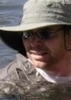
The rest of the Group showed up a few minutes early and we all piled in with Ambika and drove to First Water. We arrived to some nice sunshine and I opted to peel off my fleece hoodie and stow it in the pack. Starting out on a Hike in January in short sleeves. I hope it's not a trend for the rest of "winter".

We get started and were making pretty good time to Garden Valley. Lots of pools of water still, but nothing running up to that point. Ambika, tibber and I top out and Ambika and I head for the Junction. Tibber is videoing the SloFolks coming up the last hill and suddenly we hear tibber say there's a problem and she disappears back down the Trail. We follow and find Cathy sitting on a rock. She was complaining about being dizzy and apparently she fainted. How she didn't face plant on the rocks is a miracle. Then the questions started, trying to determine the problem. Not enough food, not enough water, low blood sugar? We were ticking them off and trying to find a solution. She was sweating pretty heavily, and had a long sleeved hoodie wrapped around her waist. Ambika told her to take it off. I helped her with it and it was soaking wet. The Light Bulbs started to go off. And then Greg mentioned that under the long sleeved shirt that she was still wearing, was a long sleeved THERMAL shirt. We had our answer. The top shirt comes off and surprise! We're not down to the thermal yet! She had a short sleeved shirt between the two long sleeved shirts. I think at that point, Minnesota was mentioned. :lol: Not sure, but it's probably the first time I've made someone strip down to almost nothing, in broad daylight, in the wilderness. Cathy had resolved to not get hypothermia on this Hike. Instead, at a sunny 68 Degrees, hiking uphill in the desert, she had Heat Exhaustion. 3 Layers on and one wrapped around her waist! Mr. SloFolk is going to have to start checking the weather and watching his wife dress. :D I'm actually amazed she made it as far as she did. If I had worn that much with my hot flashes to boot, forget the fainting, I would have dropped dead by the Second Water/Dutchman Junction. :sweat:

She didn't feel like she could continue with the Hike and Ambika was kind enough to accompany her back to her car at the TH. I had a feeling Cathy would recover and they would have a nice time awaiting us at Canyon Lake. Tibber and I really wanted Greg to see this Hike, so we decided to continue on. In all seriousness here, we were super glad that it wasn't something more serious and with Ambika taking her back, we knew she was in the best hands.

I went into detail on this and I hope I didn't embarrass Cathy with it. You think about Heat Stress when the Temperature is higher. Certainly not in January. Except maybe for Linda. But under the right circumstances, it can happen when it's colder, and to Cathy, it did. It was a wake up call for all of us. I'm glad we figured it out or it could have gotten worse on her hike back. She's also very lucky she didn't injure herself when she fainted. Just an experience to store in your Toolbox year round. Because you never know, when you're out there hiking and something starts to go wrong, it can be something you wouldn't think of.

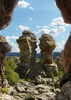
The Trek continued and it was beautiful weather. Tibber already mentioned it, but having someone along that's new to this area of the Supes, is always a treat. I think Greg enjoyed it, even if he was missing Cathy. We get to the Boulder Canyon Junction and I had a first. I hung a left. As many times as I've come down Second Water, I had always gone to the right. I have never seen the Boulder Canyon Trail between Second Water and LaBarge Creek. I was in new Territory right alongside Greg, at least for a mile or so. We rested and snacked by the running water of Boulder Creek and then continued up to the Mine. Just below the Mine, we encounter 4 Horseman and it was a double treat for me. I love horses and am always looking for an excuse to visit with them. I just regret not having a treat for them. It seemed fitting that I was petting a Paint while visiting Indian Paint Mine for the first time. :D

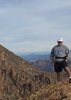
Not long after the Mine, Greg gets to see the Hill. :sweat: I've done it several times now, but I could tell from the increased sweating on his face, that Greg was thinking way too hard about it. But we had a plan and we started on up. It was warm and it didn't take me long to unzip the legs and let that white skin get some sun. Should have done it way earlier in the Hike. I have to tell you all that I found it incredibly difficult to slow the SloFolk down. I taught him the Rest Step, but he wasn't resting. [-( I finally got in front of him so he would quit racing up the hill. I certainly wasn't sprinting by any means. :sweat: I kept promising him that he was going up the last hill, but he quit believing me. So much for promises. :lol: But he made it! And I wasn't going to have to drag him down the other side, so we were good. Tibber stayed on the Trail after the last Hill, but Greg wanted the shortest route. I told him it would be steeper, but he didn't care. So we took the "alternate" route down to finish it.

Met up with Ambika and Cathy, who looked way better. We all had an early dinner at the diner watching the golden hour descend on the lake. Great way to end the day. Thanks to all for accepting my invitation. It was nice to see everyone again! I wish Cathy could have seen this Hike, but I have a feeling that she will someday. I'm just glad she was ok. Funny how we all got chilly eating dinner. I almost asked Cathy to let me borrow one of her layers... :D
 Flora
 Flora [ checklist ]
[ checklist ]  Tree Tobacco
wildflower observationwildflower observationwildflower observationwildflower observationwildflower observation
Wildflowers Observation Isolated
Things are liking this warm weather and trying to start.

water 1 out of 5water 2 out of 5water less than maxwater less than max Boulder Creek at #103 / #236 Jct Light flow Light flow


water 1 out of 5water less than maxwater less than maxwater less than max La Barge at Boulder Creek Trail #103 Pools to trickle Pools to trickle

water 1 out of 5water less than maxwater less than maxwater less than max La Barge Canyon Pools to trickle Pools to trickle

water 1 out of 5water less than maxwater less than maxwater less than max La Barge Creek Pools to trickle Pools to trickle

water 1 out of 5water less than maxwater less than maxwater less than max Second Water Canyon Pools to trickle Pools to trickle
_____________________
Life is not a journey to the grave with the intention of arriving safely in a pretty & well preserved body, but rather to skid in broadside, totally worn out & proclaiming, "Wow What a Ride!"
 
Jan 25 2020
avatar

 Guides 21
 Routes 1,183
 Photos 36,909
 Triplogs 1,571

69 female
 Joined Feb 26 2004
 Phoenix, AZ
First Water TH to Canyon LakePhoenix, AZ
Phoenix, AZ
Hiking avatar Jan 25 2020
tibberTriplogs 1,571
Hiking8.43 Miles 1,327 AEG
Hiking8.43 Miles   6 Hrs   10 Mns   1.82 mph
1,327 ft AEG   1 Hour   32 Mns Break
 
Partners partners
desertgirl
LosDosSloFolks
outdoor_lover
Route Scout Route Recorded  on Route Scout | Pop | Map | Popup | MapDEX
Tibber, Tibber, Tibber - how did the trip report get so long :stop: Pam invited us to do this trip. It is one of my favorite hikes and forgetting about the Hill, I had other plans but changed them. I invited a few other folks and Ambika also decided to join us. This would be Cathy's first exposure to hiking in the Supes and considering she is a native, it's about time. However, this time would only be a short but memorable time. Hopefully her next foray into the Supes will be much more rewarding.

I saw the forecast for a high of 68 but I think it was warmer than that. And apparently Cathy noticed it too as her apparently overdressed body said no more as we got near Garden Valley. After some discussion, she, under Ambika's watchful eye, headed back to the TH with Ambika. That was so Ambika-like to offer to go back with her :app:

The temp felt great as we headed across Garden Valley as there was a great breeze. Going between the mesas, while beautiful, is always a bit challenging with the super rocky trail so you have to pay attention to where you're walking... smack toward Geronimo's Head.

As we headed down the hill there were a few more of those Supes Steps. They sure are nice but some are already in disrepair. As we headed down the side of Second Water Canyon you could see some pools of water but not really hear any water until further down. There was a discussion as to whether this was Second Water Canyon and I opted for "dial a friend", where's Wally? Well it is Second Water Canyon. It's not nearly as brushy as you get closer to the bottom and most of the bamboo or reeds that used to encroach on the trail, don't encroach anymore. Many of the small trees seem to be missing. I did review my video from 2016 and it was indeed a lot brushier back then.

As we got to the place where you crossover to the southside, the trail seems to have disappeared or we missed it. We ended up below the big rock where there is a campsite. It looks like there was a trail going up to it from the west side but we ended up going down the creek a bit and made a two tier climb back up to the trail. I should have followed it back to see where it came up at unless it doesn't come up there anymore. Based on old tracks, it looks like the trail jigs instead of jags in that area.

Getting closer to the junction is always such a site to behold with Battleship looming high above. And then you hear the water and see the water. We took a few photos here before hiking over to Boulder Creek that runs below the Paint Mine where we had our snack. I ate almost my whole snack too. That "hill" always put the fear of God in me as when I did it the first time, I didn't think I was ever going to get out of La Barge Canyon.

At the Indian Paint Mine (known as that since 1911) we encountered some horseback riders from IL and AL. We visited for a short time. They really had some nice looking horses. Whenever I get to be near horses, it's like being a teenager and at the ranch again. I feel peace. Anyway, we walked around a bit as this was Greg and Pam's first visit. (from Boulder Canyon Hike Desc: The pit that they extracted red clay to make their paints and pottery is still apparent, and the nearby "furnace" area is still discernible.) FYI I found quite a bit more info about the mine and this area in Jack and Elizabeth's book: Superstitions Wilderness Trails West.

We continued on the crossover to LaBarge and Greg's, "can you believe this?" intensified as he was awestruck by the Superstition Mountain Wilderness we were traversing. It made me realize how lucky I have been to do even the limited amount of hiking here. And now he can appreciate why Wally can never get enough. La Barge Creek pool below the red-tinted rock had a nice amount of water in it too. But now, it was time to hike out of here and meet our nemesis head on.

I was surprised how many hikers we saw today and that would continue as we grew closer to the Hill. I wasn't sure how I would do as my confidence has come back somewhat. However, by the time I was done with the hike; I wasn't sure if I really wanted to do this one again. :lol: . Nonetheless, I forced my way up with four 60 second stops to find air. I think I only took two pictures on the way up.

I couldn't wait to find a place to rest my laurels once on top but there's not really any good place to sit. I found a place further up the trail with a view of the lake. I texted Ambika to let her know I was on the "hill" and the others were about ten minutes behind me. I sent her a photo. I was now rested and went back to see where the other two were and they were just coming atop. They walked around to get those requisite photos of the view before we began again to get over across the way. We encountered a few hikers and dogs on this portion of the trip.

The rock scenery is so pretty through this little section. And as you round the last section via a little switchback, it afforded the chance to catch a couple pictures of Greg and Pam across the way. Then as I headed up the last little bit before that saddle I spotted three singular poppies so had to stop to get the picture. Interesting that this day on HAZ, several others got first poppy of the season pictures too.

It was nice to finally hit the shade and see the beautiful Canyon Lake and dam and vista beyond. I hiked for a bit to the next side of the hill and waited in the shade for the other two and filmed them for a bit before continuing on to the top of the last little hill. I wandered around here to wait for the others and got hit with the dreaded, "will you take my picture?". Since I said "no" last weekend I reluctantly agreed. I waited for the others to get up but they were observing the mighty fine scenery so I took off down the endless hill to finally arrive at Tonto Jr.

By the time I had changed my shoes and fixed my hair and was walking to the cantina, they showed up. That was fast, and come to find out they took the steep shortcut! We had a lovely dinner at Well Done Grill (what a stupid name) but the place seems cleaner, the service was much friendlier and the food was pretty good. It was nice to see the sun slowly making the water glow gold as we made our way back to our cars for the drive home.

There are 4 videos for this trip. I'm glad I film as much as I do as in this case as I was able to look back on the 2016 video thru Second Water Canyon to see how much it's changed as far as the vegetation and it's changed quite a bit in the lower part.
Video 1 from TH thru Garden Valley - [ youtube video ] tossed in some music by HAZ's LosDosSloFolks to start
Video 2 from Second Water Canyon to Paint Mine - [ youtube video ]
Video 3 Paint Mine to slightly past the hill [ youtube video ]
Video 4 Past the hill to Canyon Lake and some time at the Lake [ youtube video ]
 Fauna
 Fauna [ checklist ]
[ checklist ]  Mallard Duck
 Named place
 Named place [ checklist ]
[ checklist ]  Boulder Creek - Superstition WA
wildflower observationwildflower observationwildflower observationwildflower observationwildflower observation
Wildflowers Observation None
one very healthy and blooming lavendar plant
_____________________
For me, sometimes it's just as much about the journey as the destination.
Oh, and once in awhile, don't forget to look back at the trail you've traveled.
  6 archives
Feb 25 2019
avatar

 Guides 187
 Routes 991
 Photos 12,084
 Triplogs 866

72 male
 Joined Jun 27 2015
 Tucson, Arizona
Lower First Water, AZ 
Lower First Water, AZ
 
Hiking avatar Feb 25 2019
markthurman53Triplogs 866
Hiking6.70 Miles 734 AEG
Hiking6.70 Miles   3 Hrs   35 Mns   2.22 mph
734 ft AEG      34 Mns Break15 LBS Pack
 
1st trip
Linked   linked  
Partners none no partners
After my Hoolie Bacon plans fell through I decided to hike down lower first Water toward Canyon Lake. I would continue until the water stopped me or I run out of time. The water in the canyon was just at the right level, good flow but not enough to make creek crossings difficult (my objective was to not have to wade through water). Without the water this would be a fairly easy creek to navigate at least as far as I went. The water made for a fun hike because unlike a trail where you deal with stuff right in front of you, on this hike you have to enable the look ahead software in the brain. You want to cross over the stream where there are objects that allow crossing before you get pinched off on your side of the stream by rocks, water or brush. Didn't do too bad going down stream with only a few bad choices, going back I did much better having already made all the mistakes going down.

Not a real exciting hike, the water made it more interesting than if the creek was dry. Did encounter my first rattlesnake of the year. Almost stepped on it as it was sitting on the grass along the stream that was also my chosen path. Didn't move much probably because of the temperature. I didn't touch it to see if it would move but it didn't mind me taking pictures. I'm thinking it was washed out of its hibernation from the water.
_____________________
 
Jan 21 2019
avatar

 Routes 61
 Photos 1,008
 Triplogs 224

44 male
 Joined Aug 19 2009
 The Basin
Boulder La Barge Hackberry Romp, AZ 
Boulder La Barge Hackberry Romp, AZ
 
Hiking avatar Jan 21 2019
survivordudeTriplogs 224
Hiking11.61 Miles 1,425 AEG
Hiking11.61 Miles   5 Hrs   9 Mns   2.61 mph
1,425 ft AEG      42 Mns Break
 
1st trip
Finally got some time to take the Lunatic out for a real hike. LOTS of people out there today but I don't blame them, the weather was fantastic! After all the rains lately, everything was super green and lush. First water was bone dry and only a few pools here or there along Second Water, there was nothing flowing in Boulder Canyon. That junction of Boulder Canyon and Second Water is quite the intersection with 10 people passing through as Luna got a water break. Checked out the paint mine. I had surprisingly never been here as I have always stayed in either LaBarge or Boulder anytime I have been out this way. Checked out some campsites and went over to Hackberry area. While going across Garden Valley to the west now, I came across a path that led up and over the mini peaks that surround the valley. Not much of a trail after that but I did pick up a faint path about halfway down which I lost again just roughed the next 1/4 mile down. Hackberry had the usual group of about 8 kids and several dogs hanging out and the pipe was dripping nice. Found a path along First Water all the way down and it turned out to be a dandy. I think I may route this way into my next hikes instead of the usual Second Water beginning. Luna did great out there today and she kept the pace the whole time.
_____________________
“There is nothing that exists outside the thought of the immediate moment.”
 
Jul 01 2018
avatar

 Photos 356
 Triplogs 44

62 male
 Joined Apr 11 2011
 Mesa, AZ
First Water TH to Canyon LakePhoenix, AZ
Phoenix, AZ
Hiking avatar Jul 01 2018
CraigbhikinTriplogs 44
Hiking7.30 Miles 1,589 AEG
Hiking7.30 Miles
1,589 ft AEG
 no routes
1st trip
Linked   none no linked trail guides
Partners none no partners
It probably in vain putting this on here, because the people that leave trash at the trail head and on the trail probably don’t read triplogs or can’t read. PACK IT IN, PACK IT OUT! I have taken short day hikes the last two weeks, and packed out 50 gallon size of trash bag out. Most people hike to enjoy the outdoors, so why leave your trash out there? If you like to see trash when you hike, go to the dump, and you can see all of the trash you want.

OK off of my soapbox. Did a short hike this morning, but ne pictures, batteries died on me. Not too hot, but in some of the lower areas it was muggy. All in all it was a good day to be out doors.
_____________________
Craigbehikin
 
Mar 01 2018
avatar

 Routes 17
 Photos 485
 Triplogs 510

77 male
 Joined Jan 07 2010
 Chandler, AZ
First Water TH to Canyon LakePhoenix, AZ
Phoenix, AZ
Hiking avatar Mar 01 2018
Mike_FelsTriplogs 510
Hiking16.54 Miles 3,395 AEG
Hiking16.54 Miles   7 Hrs   21 Mns   2.42 mph
3,395 ft AEG      31 Mns Break
 no routes
Partners none no partners
Did my annual (-1) hike over to the Dolly and back. The -1 means I missed doing it last year. Couldn't skip two years. Hit the trail at 7 am. Very cool but clear. Especially in the shade which was a good portion of the way over. Didn't see another person until a quarter of the way down that final hill into the marina. In that last mile there had to be at least 20 people. It still is a beautiful hike. Though that hill up second water was really hard on the way back. It seems to get taller and steeper each year.

Each year I have decided not to eat at the marina. But this year was different. All the way over I thought about having a late breakfast or an early lunch there. But when I arrived it was closed. In fact the sign was marked that it was closed every day of the week. Bummer! Don't know what's up. One of the people I talked to on the way back said they had eaten there Friday. Their web site is not showing them being closed.

There is a sign at the head of the trail at the marina end that says Second Water 2 3/4 miles. I don't see how they figure that. Even according to Google earth a direct line between those two spots is 2.61 miles. It's got to be about 4 miles. I wonder how many people have gotten into trouble on the trail by the inaccuracy of this sign.

I've never seen the Supes so dry. Except for the lake the only water I saw on the entire trip was a trickle coming down second water canyon. I suspect there's not going to be a very good wildflower season this year.
_____________________
 
Feb 08 2017
avatar

 Routes 69
 Photos 3,135
 Triplogs 1,855

72 male
 Joined Jul 24 2009
 Mesa, AZ
First Water TH to Canyon LakePhoenix, AZ
Phoenix, AZ
Hiking avatar Feb 08 2017
trailzrusTriplogs 1,855
Hiking8.10 Miles 1,589 AEG
Hiking8.10 Miles
1,589 ft AEG
 
Linked   none no linked trail guides
Partners none no partners
_____________________
 
Dec 30 2016
avatar

 Photos 2,699
 Triplogs 240

female
 Joined Oct 31 2007
 Middle-of-Nowher
First Water TH to Canyon LakePhoenix, AZ
Phoenix, AZ
Hiking avatar Dec 30 2016
snakemarksTriplogs 240
Hiking8.00 Miles 1,589 AEG
Hiking8.00 Miles
1,589 ft AEG
 no routes
Linked   none no linked trail guides
Partners none no partners
Hiked from Canyon Lake with Georgy.
_____________________
I'm at home in the wilderness... it's civilization I have problems with! ](*,)
 
Mar 12 2016
avatar

 Routes 59
 Photos 46
 Triplogs 71

54 male
 Joined Dec 28 2015
 Mesa
First Water TH to Canyon Lake TH, AZ 
First Water TH to Canyon Lake TH, AZ
 
Hiking avatar Mar 12 2016
AZDaneTriplogs 71
Hiking7.91 Miles 1,236 AEG
Hiking7.91 Miles   5 Hrs   19 Mns   2.04 mph
1,236 ft AEG   1 Hour   26 Mns Break
 
1st trip
Linked   linked  
Partners partners
TxGirl
Dropped a car off at Canyon Lake TH and went back to start the trail at First Water TH. Trail was surprisingly not very crowded considering it was weekend, cool weather and spring break.
The route is easy to follow and has a lot of great views of Weavers Needle, Battleship Mountain and Canyon Lake. It also passes some ruins that we later learned were the remains of an Indian Paint Mine. There are some beautiful backcountry camp sites in Boulder Canyon I definately plan on bringing my tent next time :)
wildflower observationwildflower observationwildflower observationwildflower observationwildflower observation
Wildflowers Observation Light
_____________________
 
Feb 19 2016
avatar

 Routes 110
 Photos 670
 Triplogs 204

74 male
 Joined Nov 02 2013
 Apache Junction,
First Water TH to Canyon LakePhoenix, AZ
Phoenix, AZ
Hiking avatar Feb 19 2016
rtaylor3235Triplogs 204
Hiking7.75 Miles 1,335 AEG
Hiking7.75 Miles   4 Hrs   15 Mns   2.25 mph
1,335 ft AEG      48 Mns Break12 LBS Pack
 
1st trip
Partners partners
jcroth
Went for a morning hike with my two friends John & Terre, cloudy day, perfect temp, saw a few others on the trail, but no thru hikers.
_____________________
 
Feb 19 2016
avatar

 Routes 1
 Triplogs 1

70 male
 Joined Feb 18 2016
 Apache jct arizo
First Water TH to Canyon LakePhoenix, AZ
Phoenix, AZ
Hiking avatar Feb 19 2016
jcrothTriplogs 1
Hiking7.81 Miles 1,335 AEG
Hiking7.81 Miles   4 Hrs   19 Mns   2.22 mph
1,335 ft AEG      48 Mns Break
 
no photosets
1st trip
Partners partners
rtaylor3235
Beautiful hike, great weather, new to HAZ.
_____________________
 
Feb 15 2016
avatar

 Photos 7
 Triplogs 2

70 female
 Joined Jan 10 2016
 birmingham, IA
First Water TH to Canyon LakePhoenix, AZ
Phoenix, AZ
 Hiking avatar Feb 15 2016
JenfarmsTriplogs 2
 Hiking7.30 Miles 1,589 AEG
 Hiking7.30 Miles   5 Hrs      1.46 mph
1,589 ft AEG
 no routes
Linked   none no linked trail guides
Partners none no partners
Chuck and I along with our faithful dog Jill met our hiking buddies from Venture Out (Mesa) for a crossover hike. We met at the junction of Hwy 88 and 1st Water Trail rd. - Good buddy Worth volunteered to shuttle our pickup to Canyon Lake and start his hike from there. We caught a ride to 1st water trailhead with Eddie and crew. The hikers were split into two groups of 13 and 14 each. One starting from 1st water and the other starting from Canyon Lake. Our goal was to meet for lunch and a key exchange somewhere near the Indian Paint Mine. We overshot this by a bit and met up with the Canyon Lake crew near LaBarge Creek where we enjoyed our lunch. We counted ourselves lucky the weather was so cooperative, providing a nice breeze when we were gaining elevation. We completed our trek to the Lake as it was starting to heat up. One VO hiker took a spill on a shaley downhill stretch; she was a trooper and was quickly back on the trail after a quick cleanup and application of wound bandage and several bandaids to hold it on her elbow. Thumbs up to all who assisted. This was an extraordinarily beautiful hike with several photo ops.
wildflower observationwildflower observationwildflower observationwildflower observationwildflower observation
Wildflowers Observation Light
Mexican Poppies, brittle bush, and a few other small wildflowers are just starting to show up
_____________________
 
Feb 08 2016
avatar

 Photos 7
 Triplogs 2

70 female
 Joined Jan 10 2016
 birmingham, IA
First Water TH to Canyon LakePhoenix, AZ
Phoenix, AZ
 Hiking avatar Feb 08 2016
JenfarmsTriplogs 2
 Hiking7.30 Miles 1,589 AEG
 Hiking7.30 Miles   5 Hrs      1.46 mph
1,589 ft AEG
 no routes
Linked   none no linked trail guides
Partners none no partners
Chuck and I along with our faithful dog Jill met our hiking buddies from Venture Out (Mesa) for a crossover hike. We met at the junction of Hwy 88 and 1st Water Trail rd. - Good buddy Worth volunteered to shuttle our pickup to Canyon Lake and start his hike from there. We caught a ride to 1st water trailhead with Eddie and crew. The hikers were split into two groups of 13 and 14 each. One starting from 1st water and the other starting from Canyon Lake. Our goal was to meet for lunch and a key exchange somewhere near the Indian Paint Mine. We overshot this by a bit and met up with the Canyon Lake crew near LaBarge Creek where we enjoyed our lunch. We counted ourselves lucky the weather was so cooperative, providing a nice breeze when we were gaining elevation. We completed our trek to the Lake as it was starting to heat up. One VO hiker took a spill on a shaley downhill stretch; she was a trooper and was quickly back on the trail after a quick cleanup and application of wound bandage and several bandaids to hold it on her elbow. Thumbs up to all who assisted. This was an extraordinarily beautiful hike with several photo ops.
wildflower observationwildflower observationwildflower observationwildflower observationwildflower observation
Wildflowers Observation Light
Mexican Poppies, brittle bush, and a few other small wildflowers are just starting to show up

water 1 out of 5water 2 out of 5water less than maxwater less than max Boulder Canyon Light flow Light flow

water 1 out of 5water 2 out of 5water less than maxwater less than max Boulder Creek at #103 / #236 Jct Light flow Light flow

water 1 out of 5water less than maxwater less than maxwater less than max First Water Creek at Second Water Trail #236 Pools to trickle Pools to trickle

water 1 out of 5water 2 out of 5water 3 out of 5water less than max La Barge Canyon Medium flow Medium flow

water 1 out of 5water 2 out of 5water less than maxwater less than max La Barge Creek Light flow Light flow

water 1 out of 5water less than maxwater less than maxwater less than max Second Water Canyon Pools to trickle Pools to trickle

water 1 out of 5water less than maxwater less than maxwater less than max Second Water Spring Dripping Dripping

water 1 out of 5water 2 out of 5water 3 out of 5water less than max Tortilla Creek Medium flow Medium flow
_____________________
 
Jan 22 2016
avatar

 Routes 17
 Photos 485
 Triplogs 510

77 male
 Joined Jan 07 2010
 Chandler, AZ
First Water TH to Canyon LakePhoenix, AZ
Phoenix, AZ
Hiking avatar Jan 22 2016
Mike_FelsTriplogs 510
Hiking8.61 Miles 1,962 AEG
Hiking8.61 Miles   3 Hrs   46 Mns   2.45 mph
1,962 ft AEG      15 Mns Break
 no routes
Partners partners
MNHIKER42
mtabbert
The last 4 times I did this hike I made it a round trip. Okay with age catching up to me I decided this time it had to be a shuttle trip. I enlisted the company/help of Merlin and Mike. They had never done this, one of my favorite hikes. We could not have had a better day. Sometimes the wind was a bit over stated, but then it also kept us from feeling too warm. Bolder and La Barge were flowing fairly well. No wildlife other than one cotton tail. Ate too much at the all you can eat fish fry at the marina afterward. We saw no other hikers until the last mile.
_____________________
 
Jan 22 2016
avatar

 Triplogs 428

72 male
 Joined Mar 05 2013
 Payson, AZ
First Water TH to Canyon LakePhoenix, AZ
Phoenix, AZ
Hiking avatar Jan 22 2016
mtabbertTriplogs 428
Hiking8.61 Miles 1,962 AEG
Hiking8.61 Miles   3 Hrs   46 Mns   2.45 mph
1,962 ft AEG      15 Mns Break
 no routesno photosets
1st trip
Partners partners
Mike_Fels
MNHIKER42
_____________________
 
average hiking speed 2.22 mph
1, 2, 3, 4, 5, 6  Next

WARNING! Hiking and outdoor related sports can be dangerous. Be responsible and prepare for the trip. Study the area you are entering and plan accordingly. Dress for the current and unexpected weather changes. Take plenty of water. Never go alone. Make an itinerary with your plan(s), route(s), destination(s) and expected return time. Give your itinerary to trusted family and/or friends.

helpcommentissue

end of page marker