|
| | | |
| |
|
| Hiking | 8.55 Miles |
2,653 AEG |
| | Hiking | 8.55 Miles | 5 Hrs 41 Mns | | 1.61 mph |
| 2,653 ft AEG | 22 Mns Break | | | |
|
|
| |
| Partners |
|
none
[ show ]
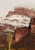
| no partners | | Janelle had asked me about this hike back near the beginning of the year. Three reschedules later, we finally got it done today. Got started a little after 0730. I showed Janelle the route we would come down and made sure she was okay with it, then we headed west up the well used trail that leads to the saddle between Black Cross Butte and Chalcedony Cave. While a little rocky, it is mostly well defined, and not too steep. Morning shade is delightful.
At the saddle, we headed west, first to Chalcedony Cave, then west towards 3042 (which seems to be misnamed as 3402???). That route has become much more defined most of the way. We reached a point where the definition fades. My old track headed west, and a newer use trail goes north. Going north seems to be steeper. There was a young couple ahead of us going up that route. We debated for a moment, then opted for west. We found hints of a track. It curved north, then we headed up the less steep western slope of 3042. We could see the couple on a very steep section of the southern part of 3042, so I was happy with the route choice we had made.
After a few minutes at the summit, we headed back down towards the Salt River Overlook. Took some pics along the edge of the sheer cliffs, then mostly retraced our steps back out. My return track from the summit all the way back is slightly better.
Once at the saddle again, we headed up to Black Cross Butte. Looked around the top, then took a break at the summit. After that, we descended off the south face of the butte for the more adventurous route down. I was able to find the route that bypasses one of the scrambles. The bypass is steep, and takes a few minutes longer, but it is a zero scrambling route, so if you’re not comfortable with the exposure of that one scramble, it is a good option. After that, we zigzagged down, carefully through the steep ball bearing slope, did the final downclimb, and finished up.
Great hike, with stunning views. Just enough route finding to keep it fun. Long pants were helpful, but shorts would be okay if you don’t mind a few scratches. There were about eight or nine vehicles at the trailhead, but I think we only saw three couples and a solo hiker, all near or west of Chalcedony Cave. |
|
Wildflowers Observation Isolated
|
|
| _____________________
| Stop crying and just go do the hike. |
| | |
|
|
|
 Route Editor


 I may need to come back another time to do Crucifix down to the river.