username
X
password
register
for free!
help
ArticlesGuidesRoutes
 
Photosets
 
 Comments
triplogs   photosets   labels comments more
Escalante Route - 23 members in 69 triplogs have rated this an average 4.6 ( 1 to 5 best )
1, 2, 3, 4  Next
69 triplogs
login for filter options
Apr 26 2025
avatar

 Guides 2
 Routes 21
 Photos 64
 Triplogs 7

male
 Joined Oct 30 2024
 Kenilworth, NJ
Grandma Spit Trail to Hopi Salt Trail, AZ 
Grandma Spit Trail to Hopi Salt Trail, AZ
 
Backpack avatar Apr 26 2025
ckoss_Triplogs 7
Backpack34.26 Miles 6,217 AEG
Backpack34.26 Miles2 Days   6 Hrs   50 Mns   
6,217 ft AEG20 LBS Pack
 
1st trip
Preface
The goal for this trip was to hike from Lipan Point to the Hopi Salt Trail on the Navajo Nation with 2 nights along the Colorado River. The group consisted of 1 experienced Grand Canyon hiker, 1 that has day hiked below the rim, and 2 hikers brand new to the Grand Canyon. In May 2024, I previously completed the Escalante Route from Tanner Trail to Grandview Trail, so I was already familiar with Tanner. Everyone in the group is a strong hiker/backpacker and April was a great time to do this itinerary especially since the Little Colorado River was blue! We planned to camp at Cardenas Beach (BC9 - Cardenas, At-Large Camping) and 0.5 mi down river from the Little Colorado River (LCR) confluence (BA9 - Palisades, At-Large Camping). Ideally, we wanted Tanner Beach on night 1, but a last minute date change made that not possible. This itinerary changed enabled us to attempt an alternate route to descend the Redwall and Tapeats layers from Tanner Trail, called the Cardenas Route or Grandma Spit Trail. More information on this route can be found from Doug Nering, Harvey Butchart, and Green/Ohlman. Breifly, descending this route with overnight packs proved to be very strenuous, more than what I expected. This was the first time that daylight savings became relevant while backpacking since we left AZ time and entered Navajo Nation (observes Daylight Savings).

Permits
This itinerary spans the Grand Canyon National Park and Navajo Nation, so 2 permits are needed: 1) Grand Canyon Backcountry permit and 2) Navajo Nation Parks and Recreation.

Predicting LCR Color
There are 2 USGS monitoring stations that are useful to provide a quantifiable prediction on whether the LCR will be its dazzling blue color. The USGS river discharge flow rate data stations near the confluence and near the spring: aim for equilibrium values of 220 ft3/sec and 0 ft3/sec, respectively. The USGS website has the ability to subscribe to real time water alerts.

Day 1
The first day began with an overload of excitement as we attempted a "short cut" from Tanner Trail to Cardenas Beach. I studied the descriptions of the route several times, including an recent trip report with photos. We started down Tanner at noon and made it to the start of the route at 2PM, which is marked by a couple rock cairns to the left of Tanner right below the drainage leading up to the saddle nearest Cardenas Butte. The view from the top of the saddle was spectacular as we saw the Colorado River bend past Unkar Delta and we were able to size up the monumental height of the Redwall across to the north, where we would descend down its drainage. The route has 2 main milestones: 1) the Redwall Break and 2) the Tapeats Cliffs. This formation on maps / satellite looks like a horseshoe shape. We contoured along the Supai making our way over to the head of the Redwall ravine. There was some loose rocks, but it was manageable with out overnight packs. We took a slight detour, passed the turn off for the Redwall to get another view of the ravine from above. There is a cairn that signifies when to start the descent to the top of the ravine. The descent through the Redwall ravine was surprisingly straight forward. There was a lot of lose scree as we continued below the ravine as we made it to the plateauabove the Tapeats. This section was difficult with overnight packs due to the constant battle of steep, loose scree. Perhaps we descended too soon and should have contoured more first. We were awarded with lots of pink prickly pear cacti blossoms. The final challenge of this route is descending the Tapeats Cliffs with our overnight packs and windy conditions. I knew the break was on the left side of the plateau, but you cannot see it until you are standing right on the edge. Once beyond the edge, an obvious chimney appears and we carefully descended one by one to ensure we did not topple each other with debris. The route then follows the top of the Basalt layer to the north. Again, it takes some time to locate the break to descend. There is a steep series of Basalt "steps" that can be climbed down with some hand work. The large boulders were key to preserve our strength since they generally did not dislodge when hopping on them unlike the ubiquitous scree. We finally reached the drainage at the base of the Red Dox hills at sunset (7PM). We quickly scurried up the slopes to meet the Escalante Route, which greeted us with actual trail! We continued above the Unkar Rapids and made our way to Cardenas Beach, where we spotted lights from afar. A river group of 11 were already setup. We chatted briefly. I slept without my tent and enjoyed the vivid night sky with a new moon while reflecting on our descent.


Day 2
This was the easiest day of the trip since it was all on actual trail, mostly the Beamer Trail. The river group offered us an extra breakfast sandwich so we split it 4 ways for our group. We started hiking towards Tanner Beach at 8AM. The drainage near Tanner Beach looked very different from a year ago. No white sand and a lower water level. Tanner Beach also has a composting toilet, which is convenient. We also ran into a hiker from NJ who shared similar mtn biking locations as us. We continued onto Beamer Trail and took a relaxing break at Palisades beach around 1PM. We planned to camp at the debris fan / beach that is 0.5 miles south of the confluence. The exposure of Beamer Trail was minimal compared to the route from yesterday. We arrived around 5PM and set up camp towards the southern end of the "beach". We could see hints of blue water from the confluence. We also celebrated on our groupmates Birthdays!

Day 3
The highlights for the final day were seeing Beamer's Cabin, seeing the USGS monitoring stations, crossing the LCR, and ascending the Hopi Salt Trail. We expressed some doubt on the best spot to cross the LCR since there were several options. We opted to cross at the Travertine ledges just up river from the biologist's camp. The trail along the LCR was very easy going up until the crossing spot. After crossing the LCR, we were faced with overgrown catclaws and lots of muddy trails all the way to the helicopter landing pad. I think there is a high route to bypass. We started the ascent to the rim at 3PM as clouds began to approach from the west. The Hopi Salt Trail had lots of historic rock cairns marking the way. The final ascent to the rim is quite steep once crossing the drainage atop the Redwall. Be sure to keep an eye out for petroglyphs near the rim. We were greeted with a colorful sunset as we met our driver at the trailhead.
wildflower observationwildflower observationwildflower observationwildflower observationwildflower observation
Wildflowers Observation Light
 
May 21 2024
avatar

 Guides 2
 Routes 21
 Photos 64
 Triplogs 7

male
 Joined Oct 30 2024
 Kenilworth, NJ
Escalante Route: Tanner to Grandview, AZ 
Escalante Route: Tanner to Grandview, AZ
 
Backpack avatar May 21 2024
ckoss_Triplogs 7
Backpack34.82 Miles 8,566 AEG
Backpack34.82 Miles2 Days   11 Hrs   30 Mns   
8,566 ft AEG20 LBS Pack
 
1st trip
This was my 1st of 2 Grand Canyon Backpacking trips for 2024.

Preface
The Escalante Route was my first excursion away from a named "trail" and onto a "route" below the rim. [Although this is nearly a trail at this point]. Initially, we planned for 3 nights at Tanner Beach, Red Canyon, and Horseshoe Mesa, but we ended up pushing from Red Canyon to Grandview TH on Day 3.

Day 1
We were dropped off at Tanner Trailhead at Lipan Point and started down the canyon by 8AM. There were several prickly pear cacti with vibrant pink blossoms all throughout the way to the head of 75 mile canyon. We made it to the top of the Redwall by 11AM and skipped down the Dox Sandstone mounds to Tanner Beach by 2PM. We saw no other hikers the entire day, even at the beach. We watched a few river trips tackle Tanner Rapid. There was a nice sand beach where the main wash met the river. [I recently visited Tanner Beach in April 2025 and noticed none of the sand in the wash remains and the river height was noticeably lower.] It was nearly a full moon throughout the night, but I snagged a few pictures of the sky after the moonset around 3AM.

Day 2
We departed Tanner Beach by 5AM and officially began the Escalante Route with Red Canyon as the target for camp that night. We took a detour to the Anasazi Hilltop Ruins near Cardenas Creek overlooking the Unkar Delta. The shoulder before Escalante Creek is an epic view since you can view the wide Furnace Flats to the east and the narrow canyons to the west. The light scrabble that bypasses a pouroff in Escalante Creek was a nice change of pace. We spent an hour or so watching rafts float by from the relaxing beach after Escalante Creek and before the bench rises up to 75 mile canyon. We made it to the slot canyon portion of 75 mile canyon by 1PM and we enjoyed the narrow walls. My hiking partner was a bit skeptical on the difficulty of the famous Papago Wall, but it was very straightforward. The chute on the descent was actually more difficult due to navigating the loose scree with our packs. We made it to Red Canyon by 5PM and enjoyed the sights and sounds of the mighty Hance Rapid. Another day of not seeing a single hiker. [Unheard of for me being from NJ].

Day 3
The [original] goal for today was to camp atop Horseshoe Mesa. We departed Red Canyon by 5AM and noticed the Desert View Watchtower way up on the South Rim during sunrise. As we were hiking towards the crossing at Hance Creek, we passed a single trail runner (our first contact since Tanner TH). He told us that when the rest of his group passed us, to tell them they are slow and to catch up :lol:. At 9:30AM we stopped and sat behind the large boulder at the creek crossing and found water flowing below the trail crossing. After enjoying the shade, we decided that we could make it to Grandview TH before sunset and not camp that night. We took took the east ascent option up past the mineshaft and mining ruins across from Page (Miners) Spring and made it atop Horeshoe Mesa after checking out the mineshaft by 2:30PM. We checked out the other ruins on the mesa and cruised up Grandview Trail to make it to the TH before sunset. As we watched the sunset, some tourists asked us to take their photo despite our exhaustion ](*,).
wildflower observationwildflower observationwildflower observationwildflower observationwildflower observation
Wildflowers Observation Light

water 1 out of 5water 2 out of 5water less than maxwater less than max Hance Creek Light flow Light flow
 
Mar 09 2024
avatar

 Guides 3
 Routes 632
 Photos 8,235
 Triplogs 604

54 male
 Joined Apr 13 2011
 Gilbert, AZ
Tanner-Escalante-New Hance, AZ 
Tanner-Escalante-New Hance, AZ
 
Hiking avatar Mar 09 2024
ddgrunningTriplogs 604
Hiking28.57 Miles 7,063 AEG
Hiking28.57 Miles   16 Hrs   47 Mns   2.00 mph
7,063 ft AEG   2 Hrs   31 Mns Break
 
1st trip
Partners none no partners
Route Scout Route Recorded  on Route Scout | Pop | Map | Popup | MapDEX
This was a quick--but intense--trip to check out some GC tread that's been on my radar for some time.

Drove up from Phoenix on Friday afternoon and checked into a hotel in Tusayan. After dinner and some relaxing, we hit the hay early for a 2:45 am wake up call. We were on the road to the trailhead at 3:30 sharp, and at Lipan Point with boots on the Tanner Trail by 4:15 am.

Weather was cold but not windy. No moon or clouds to speak of. So, it was dark! There had been a little moisture Wednesday and Thursday, but no significant moisture for a few weeks, so we hoped the trail would be mostly clear--and more important, hoped that the river (our only source to refill water) would be running clear.

Tanner. The upper part of Tanner is steep but not difficult to navigate by headlamp. Hit 75-mile saddle and could ascertain the "narrow" traverse, but I'll have to go back another time to appreciate what this actually looks like.

I was hoping to catch the sunrise from the top of the redwall descent, where there is a short spur trail that offers a great and expansive vista. We arrived there a good 25 minutes before sunrise, but hung around long enough to catch the sun reflecting off the opposing canyon walls a bit. Given our itinerary though, we had precious little time to fritter away. So, suppressing my photography urges, we plunged down the steep redwall trail.

Another mile down, we encountered our first humans--a duo that was finishing up a 10-day packrafting trip, and from all accounts, they had a wonderful time. They reported that the river was running clear and that the LCR was running turquoise. But from where we stood, the river looked pretty silty. When they turned around, they said, wow, that must have just happened overnight. Just our luck ....

Hoping that it wasn't THAT silty, we powered on to Tanner Beach, but secretly began conserving our water (I was packing a little less than 5 liters, including a bottle of Dr. Pepper).

At Tanner Beach, we could see that it was pretty silty. We had thought about bailing on the Escalante Route and returning up Tanner, but this time we couldn't resist the temptation to press on.

We chatted briefly with a couple who were cooking up breakfast and surrounded by a lot of food, suggesting they were on the front end of their trip--indeed, another 10-day trip down and out South Kaibab.

Escalante Route. After taking in Tanner Rapids, we headed of on the Escalante Route proper just as the sun finally caught up to us.

Navigation on this section of the route was easy, but involved a little more up and down than I was anticipating.

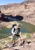
Cardenas Beach & Ruins. When we got to the junction providing access to Cardenas Beach, we again debated about whether to check it out, or try to make up some time. Ultimately, we decided to take a quick side trip. Turned out to be a great choice--not only because Cardenas Beach is a cool spot, but there also happened to be a rafting trip overnighting there. They were a friendly bunch and offered to give us a soda water and let us fill up our water. So, we immediately switched from conserving water to guzzling all we could to make room for the refill. :-)

Having filled both the internal and external bladders :lol: , we headed back up to the route proper, and took the high route up "Dox Hill" to check out the summit ruins. They were pretty neat, though didn't quite provide the 360 degree view of the bend in the river that I anticipated. So, we ventured a little further out to the point to take in the view.

Returning to the ruins and then beyond, we crossed a well-used grinding stone about 75 yards up from the ruins. Seemed a little far away from the structure. I wonder why?

The next section, heading north and then west around and beyond the Unkar Delta provided some of the best views of the Escalante Route. Super cool!

Dox Traverse & Crossover. The Dox Traverse up to the point where you cross over into the Escalante Creek drainage was a little exposed, but not bad IMO. About half way along that route, we noticed four trail runners behind us and closing in. They had very little water and only running vests on, and I couldn't fathom: (a) why a trail runner would choose this route, and (b) how in the world they would have enough water/fuel to get out of the canyon from here, as the only exits were where we came from (Tanner) or where we were going (New Hance). I had told my wife that there were no recorded deaths in the canyon along the Escalante Route, but I thought--these guys are looking like strong candidates.

Eventually the runners caught up to us and the mystery was resolved--they were with the rafting group at Cardenas beach and were just out stretching their legs, as they were staying 2 nights at Cardenas. We chatted with them for a bit and they turned around.

We stopped for lunch at the highpoint before descending into the Escalante drainage. It's a striking view--with the broad, open, eroded dox formation spreading out to the east of the ridge, and the narrowing, typical Granite Gorge heading off to the west.

After downing a bunch of calories and my Dr. Pepper, we hit the descent. By this point, the weather was warm but not too hot--at least for downhill hiking.

We passed another couple heading the opposite direction. The man seemed to be enjoying himself more than his female companion. We asked what they thought of 75-mile canyon, and they gave it a lukewarm review, but said they appreciated the shade.

Escalante Beach & 75-Mile Canyon/Beach. When we finally made it to the Escalante creekbed, we came across one of the coolest looking chuckwallas I've seen. After taking some photos, we continued to Escalante Beach and what I call Escalante Bay--an amazing, carved-out, sandy bay that peals off at the foot of a nice riffle. A great place for camping. We laid down on the beach for a bit and enjoyed the flat soft ground, while stretching our backs and giving the feet a quick rest.

Then it was on to 75-mile canyon, which we were anticipating despite the couples' lukewarm review. I'm glad to say we found it much more cool. The overlook from 200 feet above the canyon's river exit provided an amazing viewpoint, and looking down into the narrow canyon as we traversed the ledge up towards the drop in point was cool.

The drop in point was obvious and relatively easy to navigate--we walked down the sloping rock without having to resort to any butt scooting or use of hands.

Walking through the narrow canyon back to the river in the early afternoon was a real treat. Beautiful sheer walls, and shady, flat terrain were just what the dr. ordered.

After exiting, we enjoyed checking out Nevill Rapids and long stretch of fine beach that, as that time was partially in the shade.

The Low Route to Papago + Wall & Slide. At this juncture, the "official route" (if there is such a thing) ascends high and over to Papago Creek, but we had read about a low, beach route, which we decided to try. It worked out pretty good and saved us some elevation, though there is a fair amount of navigating rock slides/boulder fields once you get to the end of 75-mile beach.

Arriving finally at the storied Papago Wall, we found the "sheer" section easy to ascend. I suppose it could be sketchy for those with a substantial fear of heights, but in terms of scrambling, it's pretty non-technical.

But we ended up patting ourselves on the back too soon. Instead of ascending fully to the top of the point above the wall, as we got suckered into trying to cut across a lower trail and got cliffed out and had to backtrack a bit.

The Papago Slide on the other side looks impressive from above (as does the view downriver to Red Canyon and our exit). The Slide is much more "dangerous" that the wall, but we carefully picked our way down, and had no issues.

The remaining traverse from the bottom of the Slide to Hance Rapids/Red Canyon was "brushy" and took longer than I expected. With long pants it wasn't an issue.

Arrived at Hance Rapids at 4:15 pm. We changed out socks, fueled up, and I filled my Nalgene with a liter of silty "insurance water," in which I sprinkled a little alum and hope for the best.

New Hance. We left Hance Beach at 4:45 pm, knowing that the possibility of getting out before dark was a pipe dream at this point (sunset was at 6:30 pm).

As we headed up Red Canyon, we were in the shade, and were surprised to see water running down in the slickrock area near Red Canyon Wash. I regretted getting insurance water from the river, but at this point, we were too lazy to stop and filter--and were worried about navigating upper New Hance in the dark, so we soldiered on.

We had been down New Hance a couple of years ago, and I remember it being pretty gnarly going down, so we knew we were in for a "treat" on the way up. And so it was ....

More than any of the other south rim trails I've done so far, New Hance has been largely reclaimed by nature.

Just as we conquered a steep climb that got us above 5,000, the "trail" starts a long traverse, which actually loses elevation and crosses what seemed like a dozen rock slides. By this point, my "balancing" muscles were pretty shot, so the uneven terrain was definitely not welcome. But more concerning was the fact that after navigating a rock slide, relocating the trail on the other end was getting increasingly difficult--especially as darkness descended.

I was less concerned about my energy reserves than I was about staying on the trail. It's one thing to be hiking tired--and another to be wasting your energy hiking around in circles trying to figure out where you are supposed to go next. Thankfully, that only happened once, when I got completely turned around, and when I thought I needed to course correct by going one way, I ended up just getting further off track. After a frustrating 10 minutes or so, we finally figured out where to go next, and powered on.

It seemed like it was taking forever to get to the Coronado Butte saddle, and with no moon, we couldn't see a thing beyond our headlamps. After a while I looked at my GPS and realized that we had passed the saddle and were actually on the final, steep climb. That last climb is a beast! Navigation was still an issue, but the hand-over-fist climbing in places and the scrambly route never allows you to get in a rhythm.

About 0.3 mi. from the top, my wife (who was our designated driver) whistled down and let us know we were "close"--a relative term. :D She had walked out through the forest to the edge of the rim and down the trail a little bit to see if she could make out our ascent. She said it was hard to see our headlamps, but she could hear the clicking of our hiking poles.

At long last, we dragged our sorry butts out onto the rim around 8:40 pm, where the breeze picked up and made for cold walk back to the car.

We were wasted, but feeling great about the accomplishment and the opportunity to get in a full day of GC experience.

The drive home was uneventful. We stopped in Williams to change clothes and get gas. Drank some chocolate milk, which hit the spot. Arrived home at 2 am--37 hours; 29 miles of hiking, and 7000+ feet of aeg after we left. Whew!
_____________________
 
Jan 22 2024
avatar

 Guides 59
 Routes 1,100
 Photos 1,191
 Triplogs 1,290

male
 Joined Jan 01 2023
 Arizona
Grandma Spit, AZ 
Grandma Spit, AZ
 
Backpack avatar Jan 22 2024
pseudalpineTriplogs 1,290
Backpack7.92 Miles 5,399 AEG
Backpack7.92 Miles   7 Hrs   32 Mns   1.44 mph
5,399 ft AEG
no photosets
1st trip
Linked   linked  
Partners none no partners
  3 archives
Nov 05 2023
avatar

 Photos 380
 Triplogs 56

63 male
 Joined Mar 27 2006
 Descanso CA
Escalante RouteNorthwest, AZ
Northwest, AZ
Backpack avatar Nov 05 2023
robxxxTriplogs 56
Backpack35.00 Miles 2,481 AEG
Backpack35.00 Miles7 Days         
2,481 ft AEG25 LBS Pack
 no routes
1st trip
Linked   none no linked trail guides
Partners none no partners
Did a great Escalante route (Tanner -> Grandview) with a friend Gary Senula. We did it in 7 days with a rest day at Hance creek (day hike down Hance canyon). Was a good time , Gary knows the geology of the super group so it was nice to learn all about that.
He showed me fossilized worms , amazing stuff. Ran into a few guys having trouble locating the Papago wall, Gary taught them the way up and down the slide. The slide was a little sketchy as at one turn one has to hold onto a large rock and swing around it to get on the better route through the scree. Lots of mice at the river camps, one bit my finger in my sleeping bag ! Hope to go the little Colorado the next time ! There was water in Hance creek, didn't check out page spring on the way out, thought I saw some dark rock suggesting at least a seep is there.
_____________________
 
Nov 05 2022
avatar

 Routes 5
 Photos 435
 Triplogs 119

female
 Joined Mar 26 2022
 Flagstaff, AZ
Escalante RouteNorthwest, AZ
Northwest, AZ
Backpack avatar Nov 05 2022
shelby147Triplogs 119
Backpack28.00 Miles 7,500 AEG
Backpack28.00 Miles2 Days         
7,500 ft AEG
 no routesno photosets
1st trip
Linked   none no linked trail guides
Partners none no partners
Made a lovely overnight on the Escalante route last weekend! I love this area and particularly wanted to camp on Escalante beach someday. Happy to say, sections that made me nervous on previous trips didn't phase me at all on this one - I guess exposure to exposure helps!

I started down Tanner at sunrise on Saturday. I saw much fewer people than usual - only two parties all the way along Tanner and the beach. One woman told me about her trip down the Cardenas route to the hilltop ruin and now I'm itching to try it. I had a short break at the boater camp at Cardenas, which is pretty nice. Then I made my way up into that big drainage in the Hatakai shale.

My feet were sore from sidehilling by the time I reached the ridge leading into Escalante cr. I love the view from there - such contrast up and downstream. I was making good time so I took another break when I reached the Escalante creekbed. There I met a couple more hikers who I'd end up sharing the beach with. I left before them and had a pleasant hour before sunset to stretch on the beach and play in the sand. There's a nice little bay below Escalante which I was attracted to before. The sunset was excellent for canyon bottom sunsets - big pink and orange clouds.

I had a warm enough campsite (far back from the river) that my body didn't complain about an early start. Nevertheless, I lingered to eat breakfast on the beach again. On my way along the top of 75 mile creek I looked for possible entry points before the main break in the shinumo. I thought I found a few and confirmed that they looked viable from below - two across from each other just after entering the drainage, and one ramp to the east further down. I also thought I found an old hole from prospectors along the rim.

I met a group on the 75 mile beach who had camped at the bottom of the unnamed (hatakai traverse) drainage. They were only hiking to hance rapids that day and I was envious of the time they could take. I followed the river-level route over the Papago (it's faster and easier than the trail) then had an easy time climbing the wall and locating the upper break where I've gotten stuck before. On my way down the slide I heard voices and I was confused because I didn't think the group was that close behind me... lo and behold, another group was coming up the slide! We communicated to avoid dropping rocks on one another.

As I arrived at Hance rapid, boaters pulled in to scout. I filtered water and snacked and spent enough time on the beach for the 75m group to catch me and watch the rafters run the rapid. Then the slog up New Hance... I was definitely gassed last time I did this because it was hard but not ridiculous. I also did a better job staying on the main trail - last time, I was scrambling up a wash in the supai following cairns. I really want to hike up red canyon sometime. I saw deer trails above the tapeats crossing the saddle towards mineral canyon and there were golden cottonwoods in the creek.

I met two groups of hikers on my way out. The second were also hiking out when I passed them in the coconino - I think they weren't amused by their friend/ leader saying this route was "fine". I met their TL waiting with a car and he said he'd been denied a permit to do Escalante over 2 nights. I said a light pack helped (I maxed out at 20-22lbs with 3L water) and the office knows me.

All in all, a fantastic weekend! I biked back to Lipan Point and arrived to catch sunset.
 
Oct 13 2022
avatar

 Guides 37
 Routes 556
 Photos 10,872
 Triplogs 1,052

43 male
 Joined Jan 21 2013
 AZ
Solomon TempleNorthwest, AZ
Northwest, AZ
Backpack avatar Oct 13 2022
FOTGTriplogs 1,052
Backpack29.00 Miles 7,300 AEG
Backpack29.00 Miles3 Days         
7,300 ft AEG
 no routes
1st trip
Partners partners
BiFrost
Dave1
We headed back to the Escalante Route to complete some unfinished business from the Spring, Solomon Temple.

We started late Thursday morning from Lipan Point. The hike down Tanner felt a little warm at times and I felt a little out of shape, but we made it to the bottom nevertheless. After reaching the river, we made our way down stream along the Escalante Route and then crossed the river and floated a short stretch to reach Rattlesnake Camp, a popular stop for rafters. The river was running brown, but we had a solid system for drinking the mud water and it did not prove to be the pain we thought it might be.

Solomon went pretty smoothly on the second day, as we had done most of the approach already when we did The Tabernacle in the spring, and the summit proved pretty straightforward. Although, we did take different routes to and from the summit. I think it makes the most sense to utilize the nicely defined use trail to summit the Tabernacle and then make your way down the obvious ridgeline from Tabernacle's summit to the saddle and ridgeline system connecting the two summits. A narrow "use" trail takes you along the steep slopes of Solomon to the obvious break/steep slope that divides the two summits of the Temple. From there, a short traverse to an easy chimney takes you to a series of limestone shelves with a little exposure here and there that lead you to the highest, northern most point of Solomon. We spent a considerable time on the summit taking in the big views up river into the Unkar area and beyond to the Palisades. We replaced the old "register," which consisted of a rusted metal can and a cracked film case, and then headed back down to the river.

We spent our last day getting back across the river and completing the short climb up New Hance. Solomon Temple was my 56th Grand Canyon summit.
 Fauna
 Fauna [ checklist ]
[ checklist ]  Rattlesnake
_____________________
  1 archive
May 14 2022
avatar

 Guides 4
 Routes 491
 Photos 10,890
 Triplogs 1,257

55 male
 Joined Nov 20 2012
 Phoenix, AZ
TabernacleNorthwest, AZ
Northwest, AZ
Backpack avatar May 14 2022
BiFrostTriplogs 1,257
Backpack28.50 Miles 8,348 AEG
Backpack28.50 Miles2 Days         
8,348 ft AEG
 no routes
1st trip
Partners partners
Dave1
FOTG
Joined Lee, Dave and Spencer for The Tabernacle and a float. Kathy helped us with the shuttle and started early from Lipan Point down Tanner Trail about 415am. We made really good time down to Tanner Beach arriving just before 8. Then started the Escalante Route to below Basalt Rapid and our put in spot. Filled up the packrafts and floated to Unkar Delta with some relatively flat water most of the way.

Portaged across Unkar Delta to avoid the rapid and checked out a ruin along the way. Once on the other side it was back in the river and another float to Rattlesnake Canyon and the approach to The Tabernacle. We took a break and setup our day packs. Then headed up what turned out to be a great trail all the way to The Tabernacle summit. Arriving on the summit just before 2pm it was pretty hot. The other goal was to hike Solomon Temple as well but based on the heat and time we decided to save it for another trip. We headed back down the same way and the beach to our boats. Took another break before starting the next float.

We had several more floats and a few portages rest of the way and eventually went to Hance. Great way to eliminate some of the extra hiking and enjoy some float time without messing with any of the rapids. Hiking out New Hance Trail was also great way to exit the canyon. Really fun trip and an interesting way to see this section of the canyon!!
 Named place
 Named place [ checklist ]
[ checklist ]  Hance Rapids  Solomon Temple
_____________________
  3 archives
May 14 2022
avatar

 Guides 37
 Routes 556
 Photos 10,872
 Triplogs 1,052

43 male
 Joined Jan 21 2013
 AZ
TabernacleNorthwest, AZ
Northwest, AZ
Backpack avatar May 14 2022
FOTGTriplogs 1,052
Backpack28.50 Miles 8,348 AEG
Backpack28.50 Miles2 Days         
8,348 ft AEG
 no routes
1st trip
Partners partners
BiFrost
Dave1
Two distinct summits viewed from Ochoa Ridge back in early March caught my eye, so naturally they were added to my ever growing todo list of Canyon summits. The summits that caught my eye were the Tabernacle and Solomon Temple. Although, at the time, I actually misidentified Solomon Temple and called it Sheba. Either way, I knew I wanted to get back for the two prominent summits in an area of the Canyon that I had not spent that much time in. I cross loaded from my usual Canyon partners for the two objectives and went with a team of Karl, Dave and Spencer. Our initial plan was for a Tabernacle and Solomon linkup in a semi ambitious overnight trip utilizing a creative variation of the Escalante Route.

A 4:15 a.m. start from Lipan Point after setting up our shuttle with Kathy in the morning. We made it to the river in 3 hours and 45 minutes and walked another 20 or so minutes to the end of Basalt Rapids and launched our boats there. The float to Rattlesnake went smoothly and we enjoyed it. In particular, I liked the portage through Unkar and the prehistoric sites along the way, to include a pretty dilapidated granary that was visible from the river just after our portage at Unkar. After filtering ample water and taking a few minutes to rest, we were off for the Tabernacle by 12:15. It only took us an hour and 20 minutes to reach the summit, but we were feeling the heat after the steep ascent. After a quick discussion, we all agreed we could probably gut out Solomon Temple too, but we decided that getting back to the river and enjoying our surroundings was more appealing than another 2 hours or so in the heat, tacked on to our steep descent. The descent seemed to get warmer with every step we took and it was a bit of a knee rattler, so we were all relieved to get back to the river and our sliver of shade at Rattlesnake Beach.

With our new found confidence on the river, we decided to remove much of the walking from our itinerary and ended up floating to Hance Rapid, which included several portages and more spectacular scenery and good times. An incredible way to see the Canyon. It had been 8 years since I hiked the full length of New Hance from the river, so it was like a new trail to me and I actually enjoyed our final leg out of the Canyon.

A fantastic weekend in the Canyon with another good group. We have had a productive spring in the Canyon. I can't wait to get back to this area for a few days with the float and approach beta dialed in. So much for shoulder season, it's getting hot up there.
 Named place
 Named place [ checklist ]
[ checklist ]  Solomon Temple  The Tabernacle
_____________________
  5 archives
May 07 2022
avatar

 Guides 27
 Routes 518
 Photos 5,861
 Triplogs 883

72 female
 Joined Jan 21 2006
 Eagar AZ
Cardenas Camp to Unkar View & Hilltop House, AZ 
Cardenas Camp to Unkar View & Hilltop House, AZ
 
Hiking avatar May 07 2022
azbackpackrTriplogs 883
Hiking2.11 Miles 632 AEG
Hiking2.11 Miles   1 Hour   59 Mns   1.21 mph
632 ft AEG      14 Mns Break
 
1st trip
Linked   linked  
Partners none no partners
On a river trip, starting at Cardenas camp, just upriver from Unkar Rapids, we took a hike to a beautiful overlook of the rapids, and then hiked to Hilltop House. I'd been to this archaeological site before, when backpacking the Escalante Route. It was once somewhat rebuilt by the Park Service, back in the day when they did such work.

As typical for motor raft trips, we then ran a pretty astonishing number of big rapids that day, ending up camping at Hotauta, in the Bass area. It was my first motor trip, and I was amazed we did about 5 days worth of river running in a day. This set us up to stop at Elves Chasm the following day.
_____________________
There is a point of no return unremarked at the time in most lives. Graham Greene The Comedians
A clean house is a sign of a misspent life.
  1 archive
Apr 16 2022
avatar

 Guides 38
 Routes 182
 Photos 1,602
 Triplogs 232

40 male
 Joined Dec 09 2014
 Gilbert, AZ
Escalante RouteNorthwest, AZ
Northwest, AZ
Hiking avatar Apr 16 2022
jacobemerickTriplogs 232
Hiking25.10 Miles 7,292 AEG
Hiking25.10 Miles   15 Hrs   52 Mns   2.27 mph
7,292 ft AEG   4 Hrs   50 Mns Break
 
1st trip
Linked   linked  
Partners none no partners
Route Scout Route Recorded  on Route Scout | Pop | Map | Popup | MapDEX
After a poor four hours of sleep along FR 682, finished the drive to a frighteningly windy Lipan Point and got my gear ready for a 3AM start. Had second thoughts, then third thoughts, and hopped on the bike before fourth thoughts. The wind knocked me all over the road, made the downhill sections feel like flat ground, turned the uphill sections borderline impossible, and the 6.5 mile ride took close to an hour. Stowed the bike, kissed the ground, and started the hike proper at 4AM.

New Hance
Wind became manageable shortly after dropping below Coronado Butte. No ice or seasonal damage to note. Trail was easy to follow in the dark. Steep sections, coupled with my water-heavy pack (an overly-cautious 10L), had my knee barking in short order. Think I prefer going up this one, assuming proper hydration. Made slow time and didn't reach the river until 7:40AM, which happened to be exactly when a group of campers were packing up for their day.

Escalante
As I was going W -> E, the first milestone was Papago Wall. There was a very tempting trail that stuck to the beach that I almost followed (my knee was v unhappy after that descent), tho it doesn't seem to go all the way through? Heading up the scree was surprisingly easy, and dropping down the other side was also no biggie. I am not comfortable with climbing/scrambling, especially solo, and the two climbs were both near the bottom and easy to do butt-in or butt-out, depending on comfort level. After that was Seventy-Five Mile (slot) Canyon, which was pretty neat. However, by the time I reached Escalante Creek it was 10AM (way behind schedule) and I was struggling (stupid knee) so I took an extended break to re-evaluate my planned day.

The break helped (ate a bunch of food, took some Ibuprofen, costume change, guzzled a few liters) so I decided to continue. Climbing up and through Escalante Creek and around 4352' felt good, and cruising down the other side with the fantastical colors and rolling hills of Furnace Flats was borderline spiritual. Speaking of, the furnace was definitely cooking today, and the winds across the open land were welcome. Reached Tanner Beach around 3PM (now a full 2 hours behind schedule) and filtered a few liters before the climb.

Tanner
I loved this trail. Plus I was pushing a lot of water (drank a liter almost every mile), so there was no chance of cramps. At first I thought it would be Hermit-esque, with a few big climbs separated by long traverses, but it was a lot more gradual, easy to stick to a pace, and the Supai section was dominated by Cardenas & Escalante Buttes. Even that grind for the last 1.5 miles felt good. Compared to New Hance & Grandview, this trail is an excellent shape. Finished up under the full moon with a big smile.

Had serious doubts about this one. 10L should have been enough for me in good conditions, but the wind & knee conspired to slow me down. Luckily the Colorado was clear enough for some quick filters and I was able to keep well-hydrated, and that "reset" at Escalante Creek really helped make this a wonderful experience.
 Named place
 Named place [ checklist ]
[ checklist ]  Escalante Creek  Red Canyon

water 1 out of 5water less than maxwater less than maxwater less than max Escalante Creek Pools to trickle Pools to trickle
Two small trickles along the trail. With patience and some digging you could probably pull some water out.

water 1 out of 5water less than maxwater less than maxwater less than max Red Canyon Pools to trickle Pools to trickle
Trickling water from "spring" all the way to where the trail first enters the creek, then it's dry to the River.

dry Tanner Canyon Dry Dry
_____________________
 
Mar 31 2022
avatar

 Guides 6
 Photos 346
 Triplogs 225

69 male
 Joined May 13 2002
 Tempe, AZ
Escalante RouteNorthwest, AZ
Northwest, AZ
Hiking avatar Mar 31 2022
hikeazTriplogs 225
Hiking12.00 Miles 2,200 AEG
Hiking12.00 Miles   8 Hrs      1.50 mph
2,200 ft AEG
 no routes
Linked   none no linked trail guides
Partners none no partners
Becoming more of a 'trail' now across the western portion; still a nice, fun section of GC hiking.
Broke it up with an overnight at Escalante Creek; although if that buttress that drives you up-and-over at Papago were 'removed' (Hayduke?).......
wildflower observationwildflower observationwildflower observationwildflower observationwildflower observation
Wildflowers Observation Isolated
_____________________
"The censorship method ... is that of handing the job over to some frail and erring mortal man, and making him omnipotent on the assumption that his official status will make him infallible and omniscient."
George Bernard Shaw
 
Mar 18 2022
avatar

 Photos 60
 Triplogs 10

male
 Joined May 14 2020
 Tempe
Escalante Route-ish, AZ 
Escalante Route-ish, AZ
 
Backpack avatar Mar 18 2022
WataugaTriplogs 10
Backpack26.46 Miles 8,135 AEG
Backpack26.46 Miles2 Days      30 Mns   
8,135 ft AEG21.7 LBS Pack
 no routes
1st trip
Partners none no partners
This trip was a condensed 3 day/2 night trip along the Escalante Route. We entered the canyon on the Tanner Trail, took the Escalante Route west and then exited the canyon on the New Hance Trail.

Day 1:

With a slightly late start, we left Lipan Point and headed down the Tanner Trail at 10:00 AM. The weather was clear and sunny with temps in the 40's. The first mile of the trail was covered with ice and snow that made traction a necessity. This was my first time using Black Diamond's Blitz spikes (fore-foot only) and they performed well. Our pace was slowed by the ice and we managed to cover just a single mile within the first hour. After that the ice gave way to a great trail that descended into the canyon. Camp was set at Tanner beach, where the Colorado was running a beautiful blue-green shade. There is a pit toilet there as well as several dispersed areas for single tents. Total mileage for the day was 8 with a descent of 5070'.

Day 2:

This was our longest day of the trip and the goal was to hike the entirety of the Escalante Route down to Hance Rapids. Weather was slightly cloudy which helped keep things relatively cool throughout the long stretches of sun exposure. The first 3 miles of trail meander near the Colorado before turning south and heading higher in elevation. Around this point the trail splits into a high route and a low route. I'd recommend taking the high route to check out the ruins of a stone building on top of the hill that overlooks Unkar Creek Rapids. Shortly thereafter the trail skirts the edge of a ~600' cliff with amazing views of the Colorado.
From this point on the main climb of the day started. We hiked up along a red ridge before cresting over and dropping down to Escalante Creek. This is a great spot to take lunch, but don't be tempted by the immediate access to the Colorado. Once you reach the river, hang a left (down stream) and you'll find Escalante Beach. It's a beautiful crescent-shaped beach that we only noticed once we had continued hiking and the trail climbed back up the canyon wall. Next time, I guess. We were soon greeted with the mouth of 75 Mile Canyon and a breath taking view down to the floor below. From here the trail skirted the eastern rim until we reached a point at the end where we could safely drop into the slot canyon. Being surrounded by narrow and towering walls was a nice change of pace after spending the morning in the expanse of the main canyon. Once we exited 75 Mile we were back in the pattern of dropping down to the river, and climbing up from the river.
The next big feature of the day was the Papago Wall. After dropping down to the river again (surprise!) we were a little disappointed by the wall's diminutive size. Reports that we had read, and videos that we had watched, all hyped up the climb up the Papago Wall, but it was a quick and easy task for everyone in the group. The Papago Slide, however, lived up to the hype and was a nice descent to navigate down to our camp at Hance Rapids. Like Tanner Beach, there were several small sites hidden amongst the vegetation as well as one large one. I really enjoyed pitching my tent on a soft and sandy surface compared to the rough patches I've become used to here in Arizona. Total mileage for the day was 12.4 with a climb of 2798' and a descent of 2548'.

Day 3:

Our final day of the trip was the shortest with regards to miles, but the toughest when it came to elevation gained. The New Hance Trail starts in the wash of Red Canyon before heading up the canyon wall at roughly mile 1.5. Save yourself some time and head straight to the wash from camp rather than trying to bushwack your way to the trail like we did. This was a long grind of a hike but the ever-changing views kept me motivated. I've never hiked on another stretch of trail that had such vivid colors from the rocks, sand, canyon walls, and vegetation. The trail was very easy to follow until roughly the 3 mile/5000' point and then it became more of a route where I relied on cairns and footprints to guide me. Most of the final stretch is up the higher reaches of Red Canyon where you come close to hitting the saddle before turning south and switchbacking up the final ~1000' to the edge of the rim. Traction was needed for the last ~1/8 of a mile. When we left Lipan Point on Friday morning Sunday's forecast was calling for a 60% chance of rain in the canyon and snow on the rim. Much to our surprise and satisfaction this was completely wrong and we were able to hike out on a clear and sunny morning. Total mileage for the day was 6 with a climb of 4734'.
  1 archive
Nov 25 2021
avatar

 Guides 59
 Routes 1,100
 Photos 1,191
 Triplogs 1,290

male
 Joined Jan 01 2023
 Arizona
Tanner to Grandview - GCNP, AZ 
Tanner to Grandview - GCNP, AZ
 
Backpack avatar Nov 25 2021
pseudalpineTriplogs 1,290
Backpack32.33 Miles 9,089 AEG
Backpack32.33 Miles   19 Hrs   39 Mns   1.92 mph
9,089 ft AEG
 
no photosets
November 25-28, 2021 with Kriket.
Frigid motorcycle shuttle...
@xdadventure
Thank you!
  7 archives
Feb 20 2021
avatar

 Guides 12
 Routes 192
 Photos 863
 Triplogs 356

42 male
 Joined Nov 30 2015
 Phoenix, AZ
Escalante RouteNorthwest, AZ
Northwest, AZ
Hiking avatar Feb 20 2021
ShatteredArmTriplogs 356
Hiking28.59 Miles 7,665 AEG
Hiking28.59 Miles   12 Hrs   39 Mns   2.37 mph
7,665 ft AEG      34 Mns Break
 
no photosets
1st trip
Linked   linked  
Partners none no partners
Been wanting to do this one for awhile, so jumped on the opportunity when a friend was organizing a trip. Started before 4am, so I still haven't really seen Tanner Trail... Campers were just stirring when we got to Tanner Beach.

Trail was pretty easy to follow most of the way. 75 mile canyon was nice. Got to Papago by 11:30am. Quick climb up the wall and down the slide to Hance Beach. Wall/Slide really weren't a big deal, and I thought I get sketched out too easily. Stopped at the beach for lunch.

As we were starting up Red Canyon, the gusts finally started, which made the hike up a little more interesting. New Hance is always a good grind after leaving the creek bed. Tired at the end, but thoroughly enjoyed the trip.

dry Escalante Creek Dry Dry

water 1 out of 5water less than maxwater less than maxwater less than max Red Canyon Pools to trickle Pools to trickle
There's a good trickle in the slickrock area where New Hance drops in.
_____________________
 
Feb 13 2021
avatar

 Routes 8
 Photos 2,243
 Triplogs 204

38 male
 Joined Mar 07 2009
 Colorado Springs
New Hance TrailNorthwest, AZ
Northwest, AZ
Hiking avatar Feb 13 2021
ultrazonaTriplogs 204
Hiking6.90 Miles 4,435 AEG
Hiking6.90 Miles
4,435 ft AEG
 no routes
Linked   linked  
Partners none no partners
Minimal snow at both New Hance and Tanner. Did route clockwise.
_____________________
  1 archive
Feb 13 2021
avatar

 Routes 1
 Photos 2,050
 Triplogs 425

46 male
 Joined Sep 16 2011
 Phoenix
Escalante RouteNorthwest, AZ
Northwest, AZ
Backpack avatar Feb 13 2021
VolcanoCLMBRTriplogs 425
Backpack26.00 Miles 8,072 AEG
Backpack26.00 Miles3 Days         
8,072 ft AEG36 LBS Pack
 no routes
1st trip
Linked   none no linked trail guides
Partners partners
ultrazona
First time back to Arizona since I left to travel the world alittle over 3 years ago. What a great trip this was. We got rain, and some hail going down on New Hance on day one. Perfect sunny day on day two on the Escalante trail and a nice and cool day on day three on our hike out on Tanner.
_____________________
The world is my playground!
 
Jan 16 2021
avatar

 Guides 4
 Routes 491
 Photos 10,890
 Triplogs 1,257

55 male
 Joined Nov 20 2012
 Phoenix, AZ
Escalante RouteNorthwest, AZ
Northwest, AZ
Backpack avatar Jan 16 2021
BiFrostTriplogs 1,257
Backpack27.42 Miles 8,582 AEG
Backpack27.42 Miles3 Days         
8,582 ft AEG
 no routes
1st trip
Linked   linked  
Partners partners
John9L
Jonnybackpack
slowandsteady
Finally made this trip after talking about it for a while. We did Escalante Route starting from Lipan Point after we setup the shuttle from New Hance trailhead. Down Tanner trail about 1030 with a little bit of snow in the top section. Great trail so we made it to camp relatively early which was Tanner Beach. Good camp but a bit cold with some frozen slush in the water bag.

All packed we started on the Escalante Route downstream first passing the ruin above Cardenas and a short break. Great views as we climbed away from the river and across the long traverse into Escalante Creek. Took a break at the beach of Escalante Creek and the river. Then continued down river to Seventyfive Mile Creek which was very cool section. Fun hike along the rim and the drop into the canyon following the narrows back out to the river. From there another traverse over to Papago Wall. Once at the wall I heard someone yell Karl and looked up to see my friend Joel @RedwallNHops and his group. Always fun when you run into hiking friends unexpectedly and chatted for a while. It was getting late so we continued up the wall and down the slide which took some time. Papago Slide is pretty loose and steep especially with big packs. After that about 1 mile to camp at New Hance Rapids.

Another nice night in camp and this time water did not freeze. Next morning we packed up and hiked out New Hance. John was a little ways ahead and managed to get the other shuttle vehicle by the time we reached the rim. Great trip!
 Named place
 Named place [ checklist ]
[ checklist ]  Seventyfive Mile Creek
_____________________
  3 archives
Feb 27 2020
avatar

 Routes 2
 Photos 64
 Triplogs 10

35 male
 Joined Sep 09 2015
 Tucson, AZ
Tanner to Grandview GC, AZ 
Tanner to Grandview GC, AZ
 
Backpack avatar Feb 27 2020
derpsquadTriplogs 10
Backpack30.00 Miles 9,400 AEG
Backpack30.00 Miles5 Days         
9,400 ft AEG
 no routes
1st trip
Day 1: Tanner to Cardenas Creek
Ice down Tanner for the first mile. Good thing we all had microspikes. Super steep trail with beautiful views all the way down to the river. Pretty good campsites at Tanner beach and a vault toilet. We filled water and pushed on to the beach at Cardenas creek for the night. Could definitely see running into a large river trip here but there is a lot of room.

Day 2: Cardenas Creek
Chilled at the beach all day. I have to give a shout out to Water Wizard flocculant. Just a few drops from an eye dropper bottle flocculates all the silt in under 5 minutes. Much easier than alum. Saw two small rafting trips float by. Two guys hopped out and gave us beer which was awesome.

Day 3: Escalante Route, Cardenas to Hance Rapids
What an adventure this trail is. Every corner provides a different perspective of the Colorado. Highlight of the trip for sure. Seventy-five mile canyon was pretty special. The Papago Wall and Slide aren't that bad at all.

Day 4: Tonto Trail, Hance Rapids to Hance Creek
Pretty decent elevation gain but nothing too crazy. Good views from the Tonto plateau. Hance creek is a special place to camp with clear, running water. I could see it being popular when in season. Up to now, we only saw a solo hiker and a group of three.

Day 5: Hance Creek to Grandview
This is quite the climb but you are rewarded with excellent views of the canyon the whole way up. About a mile from the TH we started to run into a few people.

Overall, I was surprised by the solitude - is it always like this in the winter? Can't wait to explore more of the GC - anyone have some more routes they could recommend?
_____________________
 
May 17 2019
avatar

 Guides 4
 Routes 491
 Photos 10,890
 Triplogs 1,257

55 male
 Joined Nov 20 2012
 Phoenix, AZ
Wontans Throne Attempt, AZ 
Wontans Throne Attempt, AZ
 
Backpack avatar May 17 2019
BiFrostTriplogs 1,257
Backpack41.60 Miles 11,494 AEG
Backpack41.60 Miles3 Days         
11,494 ft AEG
 no routes
1st trip
Linked   linked  
Partners partners
Dave1
We made the drive up to Tanner trailhead Friday morning and started about 9am. The plan was to hike down Tanner Trail to the beach on the river and then continue on the first part of Escalante Route downstream towards our destination Unkar Creek. However, instead of hiking the 3 miles of Escalante Route to Unkar we ended up pack rafting that distance from just below Tanner Rapids to Unkar Rapids. Most of the current between rapids is fairly calm with only a few riffles.

Once we were in Unkar Creek we headed upstream to find a camp. We were surprised by a pleasant flowing stream in Unkar that Dave had mentioned last time was nearly dry. Eventually we found a good camp spot about 6 miles upstream to set us up for the summit attempt.

Next morning started hiking around 6am up canyon towards Freya Saddle which was top of the red wall. The red wall break to Freya included two bypasses around pour offs but they were fairly short and easy to navigate. We made the saddle by 830 and then continued on the traverse over to the Supai layer which was the next obstacle. The traverse is very long rough terrain so it took us a few hours to navigate to the Supai. From this point we didn’t have good data on the Supai route so we had to figure it out and piece together the route. There were some cairns that assisted getting through several layers but eventually we cliffed out on the top Supai layer. We looked around and tried several different approaches but could not find anything that looked like the right route or could work for us. After several hours trying figure out the puzzle we decided that a summit was no in our future.

We took a break before heading back on the traverse to Freya Saddle. The trip was faster going back and the down climb from the saddle back to camp also went fairly quick as well. Once back at camp we decided to pack up and hike the 6 miles back to the Colorado to make the last day shorter. We made camp late around 730 but still some light to setup.

Next day we just had to hike out from Unkar up the Escalante Route back to Tanner beach and then up Tanner Trail to the vehicle. The clouds rolled in on the hike out so the temps were cool and towards the top it started to rain and actually quite cold on the rim with wind and rain. Despite not making the summit it was a fun weekend in the canyon and we learned more about the route. Just need better data and research to make the summit more likely.
_____________________
  1 archive
average hiking speed 1.82 mph
1, 2, 3, 4  Next

WARNING! Hiking and outdoor related sports can be dangerous. Be responsible and prepare for the trip. Study the area you are entering and plan accordingly. Dress for the current and unexpected weather changes. Take plenty of water. Never go alone. Make an itinerary with your plan(s), route(s), destination(s) and expected return time. Give your itinerary to trusted family and/or friends.

helpcommentissue

end of page marker