|
| | | Little Wolf - Pine Creek - Grapevine Loop, AZ | | | |
|
|
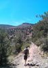
Little Wolf - Pine Creek - Grapevine Loop, AZ
| | |
| |
|
| Hiking | 16.32 Miles |
3,867 AEG |
| | Hiking | 16.32 Miles | 10 Hrs 24 Mns | | 1.81 mph |
| 3,867 ft AEG | 1 Hour 23 Mns Break | | | |
|
|
| |
| Partners |
|
[ show ]
| partners | |
Big Bug Mesa Trail 9434 seems to have taken a hit after the Big Bug Mesa fire of June 2016.
There was some trail at the beginning and some at the end towards the saddle. In between, we scrambled around the washouts. The first of many scrambles on the day.
At the saddle is where we intersected the Little Wolf Creek Trail #304. This one was in great shape because of recent fence repair and horse traffic. So recent, that we ran into the group doing repairs. We expressed our thanks and exchanged pleasantries in different languages and were on our way.
A bit of road walk over to where we went off trail last time. I remembered this section only being bad after jumping out of the wash. This is the last time for this hiker taking this "Shortcut". Manaznita push is not fun.
Great to be back on a trail again. We took the Pine Creek Trail #289, up to the dry Seaton Spring area for a well deserved lunch.
After lunch, Off Trail again, straight uphill to the NE and North through more thick stuff and rock climbing.
Joe woke up a rattler on the way up.
The walk across the mesa was a welcome one with flashbacks of flash floods, 6 years ago, hiking with Joe and Turtle.
[ photo ]
We opted to drop off the mesa to the east to get to Grapevine Springs. In hindsight, we should have continued a little further to a/the real trail.
Once on the Grapevine Springs Canyon Trail #4, It was clear sailing. Plenty of water, tons of Columbine, Ponderosa, and croaking frogs. This is the section that gets all the traffic to the area.
Thanks to Karl for driving allowing us to cut 1.6 miles off of the hike. |
|
Wildflowers Observation Light
|
|
| _____________________
There is a very fine line between "hobby" and "mental illness."
Dave Barry  |
| | |
|
|
|
 Route Editor


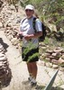


 .A couple of tough Hombres!A pleasure to hike with them and I hope they are both OK!

