|
| | | Boucher Hermit Loop via Waldron, AZ | | | |
|
|
Boucher Hermit Loop via Waldron, AZ
| | |
| |
|
| Hiking | 32.00 Miles |
8,003 AEG |
| | Hiking | 32.00 Miles | 17 Hrs 22 Mns | | 2.09 mph |
| 8,003 ft AEG | 2 Hrs 4 Mns Break | | | |
|
|
| |
| Partners |
|
none
[ show ]
| no partners | | In celebration of another successful evolution of the earth around the sun since my birth, my wife and I planned a weekend trip to tackle this as a day hike. Thanks to @jacobemerick for the inspiration.
Given the length of the hike, the shuttle to/from Hermit's Rest didn't run early enough or late enough to accommodate our plans. So, we opted to access the loop via the lesser-known Waldron Trail, which is accessible 24/7 (with a high clearance vehicle).
We booked two nights at Maswick Lodge and headed up from the Valley around 11 am on Friday. On the way into the park, we tested out the driving directions to the Waldron parking area, which is about 1 mile shy of the actual trailhead, but blocked off at that point by a locked gate. Thanks to @john9L for putting together a driving route. The road to the parking area is rutted and deteriorated in places--particularly the last 1.4 miles, but fine with medium clearance.
From the Waldron Parking area, it's about a 15-20 minute drive directly to Maswick Lodge. We checked in to our room and then walked out to the rim by Bright Angel trailhead and over to get some ice cream, then watched the sunset from El Tovar. Headed back to Maswick and hit the hay around 7:45 pm, in anticipation of an early wake up call.
Got up at 3 am and were at the Waldron parking area and on the trail just shy of 4 am. The moon was a waning gibbus and provided ample light, supplemented with headlamps here and there. Forecast temperature was near freezing, but it didn't feel that cold. No breeze to speak of, which was also a plus. Long sleeve shirt with a hood, and shorts covered with light jogging pants, was my garb of choice, and worked out great.
Waldron Trail
The 1 mile road walk from the parking area to the Waldron TH was uneventful. Slightly downhill, with several deadfall trees and various plants/bushes growing up and blocking the road. In a couple of spots, distinguishing the road from the surrounding forest was a little challenging in the dark, but no real navigation problems.
It's another 1.7 miles from Waldron TH proper to the Hermit junction. At the Waldron TH, the trail hangs a right and heads off into the forest. The first 1/4 mile or so was a bit indistinct, with a blanket of pine needles covering the path. We passed a mostly decomposed but nearly intact elk carcass along the trail. When we returned 17 hours later, the carcass had been strewn about with more pieces missing. Along the trail we saw a lot of what we figured was Mountain Lion scat and wondered if this was a food cache(?).
At about .6 from the TH, the trail dips down, across and up the other side of the drainage/gully before starting its descent into the canyon in earnest. At this point, along the steep switchbacks, the forest canopy opened up with moonlit views of the the canyon. The trail is unmaintained, but was generally easy to follow. Only minor corrections needed, but it was nice to have a GPS route--especially in the dark.
Arriving at the Hermit junction, it was another quick 0.3 mi. to the Dripping Springs junction that would mark the return point of our lasso loop, and then another 1.1 miles further on to the Boucher trail junction. I had hiked this section previously over to Dripping Springs. We passed through the two amphitheaters and tested the solid echoes, as well as the night photo taking abilities of our iPhones.
Boucher Trail
Boucher was new tread for me. Of course, we could have done the loop in the opposite direction (as others have), but after climbing my way up New Hance in the dark on a moonless night, I learned that I'd rather ascend a known and somewhat more established trail at the end of the day in the dark.
It was still dark as we stepped off onto Boucher, but the trail was relatively easy to follow. Another 30 minutes into the traverse, it was light enough to put away the headlamps.
Our goal was to get to Yuma Point (approx. 2.5 mi. from the Boucher junction and 6-7 miles from our starting point) to watch the sunrise. We timed it well, and arrived at the expansive and impressive dry camping area on the Point just as the sun was lighting up the eastward-facing buttresses. Wow!
Yuma Point also has some deep Esplanade pockets that would provide a water source and make this an ideal camp after some rain. On this day though, the tinajas were dry.
After a solid break and soaking in the views at Yuma Point, we continued on along the western side of the point to our second big descent. We'd read about this section--steep and loose. It lived up to the description, but was actually not as bad as I had worried. Would be more challenging with a backpack, but with daypacks, we took it slow and had no problems.
Crossing the Travertine Canyon drainage, we had to climb up the other side a bit before contouring over to the saddle below Whites Butte and the start of our third descent. This one is also billed a steep and loose. Certainly steep, but the top part is more solid rock, only transitioning to ball-bearing rocks as you get a bit lower.
With westerly descents, we continued to enjoy shade all the way down Boucher.
At the Tonto Junction, we turned left for the 350 ft. 0.7 mi. descent to pay our respects to Louis Boucher's cabin and check out the campground and creek. The shack remains were fun to see, and the creek a lovely respite. I tried to imagine the fruit orchard and garden. No expansive views, but a lovely place for a hermit to call home for 20 years.
We decided not to filter water at Boucher Creek. as we started with 3+ liters and a Dr. Pepper, and still had around 2.5 liters, with 5 ish miles on the Tonto to Hermit Creek. In hindsight, we could have used an extra liter, but it was fine. High temps at the river were expected to be only in the upper 70s, and we still hadn't had any direct sun to speak of.
Tonto Trail
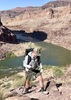
We climbed back up to the Tonto junction and headed off along the gently rolling flatness that the Tonto typifies. There are some spectacular vistas down to the Colorado, offering continuous views of the river from above Hermit Rapids to below Boucher Rapids.
14.5 miles in, as we re-entered lower Travertine Canyon, we crossed paths with our first humans--4 guys who were hiking in the opposite direction after having overnighted at Hermit.
Rounding the east side of Travertine Canyon is an impressive mostly dryfall representing the canyon's namesake travertine. It's Mooney-falls-esque, without Havasu Creek, but certainly at one time in the historical past, it sported a similarly majestic water feature.
Coming in above Hermit Camp, we were a bit surprised to see the campground pretty heavily occupied, with at 4-5 groups camping there (with more to come later in the day). We filtered at the creek above the campsite and relaxed in the shade and ate lunch before heading down to Hermit Rapid.
In hindsight, we wished we would have saved lunch for the river, since we arrived at the rapids just AFTER a group of 6 rafts had run the rapids.
Hermit Creek/Rapid
The Hermit drainage itself is a lovely oasis. There is a fantastic narrows section with a 12-foot waterfall that I would have loved to play in, with more time, followed by a beautiful slickrock section with the creek running through it.
I expected there to be more of a "trail" to the rapids, but there is more choose-your-own adventure than anticipated, along with some mild bushwhacking. That said, our return route was more efficient than our meander on the way down.
Reaching Hermit Rapids is an impressive and powerful sight. As noted, we just missed seeing several rafts go through, which would have been amazing. I've been to several rapids in the Canyon, and so far Hermit is the most impressive by far--with powerful holes, standing waves, and cross currents that would make this one quite the adventure. And there are excellent, front-row viewing spots all along the rapid. We did see one kayaker take on a bit of the lower part of the rapids (which is just as intimidating at the upper section). We hung around for 20-30 min in hopes of another group coming through, but no luck. And by 3:10 pm, and with a full 10+ mile canyon ascent in front of us, we decided we needed to get going.
On the way back up the creek, we intended to take the shortcut offshoot ramp to reconnect with the Tonto, but weren't paying enough attention and missed it. No worries, as it gave us another chance to enjoy the slickrock and narrows sections with the nice late afternoon light.
At Hermit Camp, it was a mini-city, with gobs of backpackers. Thankfully, it's a big site. Folks were looking at us funny with our day packs and surprised that, this late in the day, we were planning to climb all the way out. We filtered 3 more liters of insurance water and headed up! (I ended up dumping out a couple of liters at the base of Waldron.)
Hermit Trail
After leaving Hermit camp, we resumed our solitude, passing only one other hiker the rest of the hike--a single woman backpacking without a permit and wondering where she should camp. She planned to exit via Bright Angel, so we directed her to hang a right at the Tonto junction as her best option was Monument Creek, given the lateness of the hour.
We ascended the Cathedral Stairs in the waning light of the day, which cast a lovely glow on the ragged top of Cope Butte. What a beautiful area!
Shortly after topping the Stairs, night set in. The moon wouldn't rise until we were nearly finished with our hike, so we did the last 3 hours by headlamp.
The traverse back to the Hermit/Dripping Springs junction seemed to go on forever, with mild variations in the elevation over several miles, consistently hovering around the 4500 ft. mark.
At length, we made it to Santa Maria Spring, and knocked off the final 0.6 mi. to complete the lasso loop.
Waldron 2.0.
From there, we trudged up to the Waldron Junction and prepared to retrace our steps to the rim. The trail was even more distinct on the return trip, and we didn't have to consult the GPS track once.
We slowed a bit on the final climb, but didn't take any breaks to speak of, and just kept plugging away.
Where the Waldron Trail levels off, the cold of the night began to kick in, with a mild breeze passing through every once in a while. No longer heated by the climb, my wife put on another layer as we made our way back to the Waldron TH and then the final mile to the parking area.
As we approached our car, the waning gibbus moon rose again and stared at us through the forest. We hit the parking area at 9:15 pm. A short drive back to Maswick, and the hot showers were on. Hit the hay by 10:30 pm, happy to be able to get a restful night's sleep in before driving home.
Post-Hike
Sunday morning, we awoke from our deep sleep feeling surprisingly good! After breakfast and hot chocolate on our balcony, we packed up and drove home via Desert View Drive, with stops at Grandview and outside the park at one of the LCR overlooks. Made it back to the valley by mid-afternoon, reveling in the newly created memories that always accompany an epic Grand Canyon adventure!
A very satisfactory b-day celebration indeed! And my wife--who probably was thinking about how other wives just have to bake their husbands a birthday cake--was a rockstar!   |
| _____________________
| | |
|
|
|
 Route Editor