|
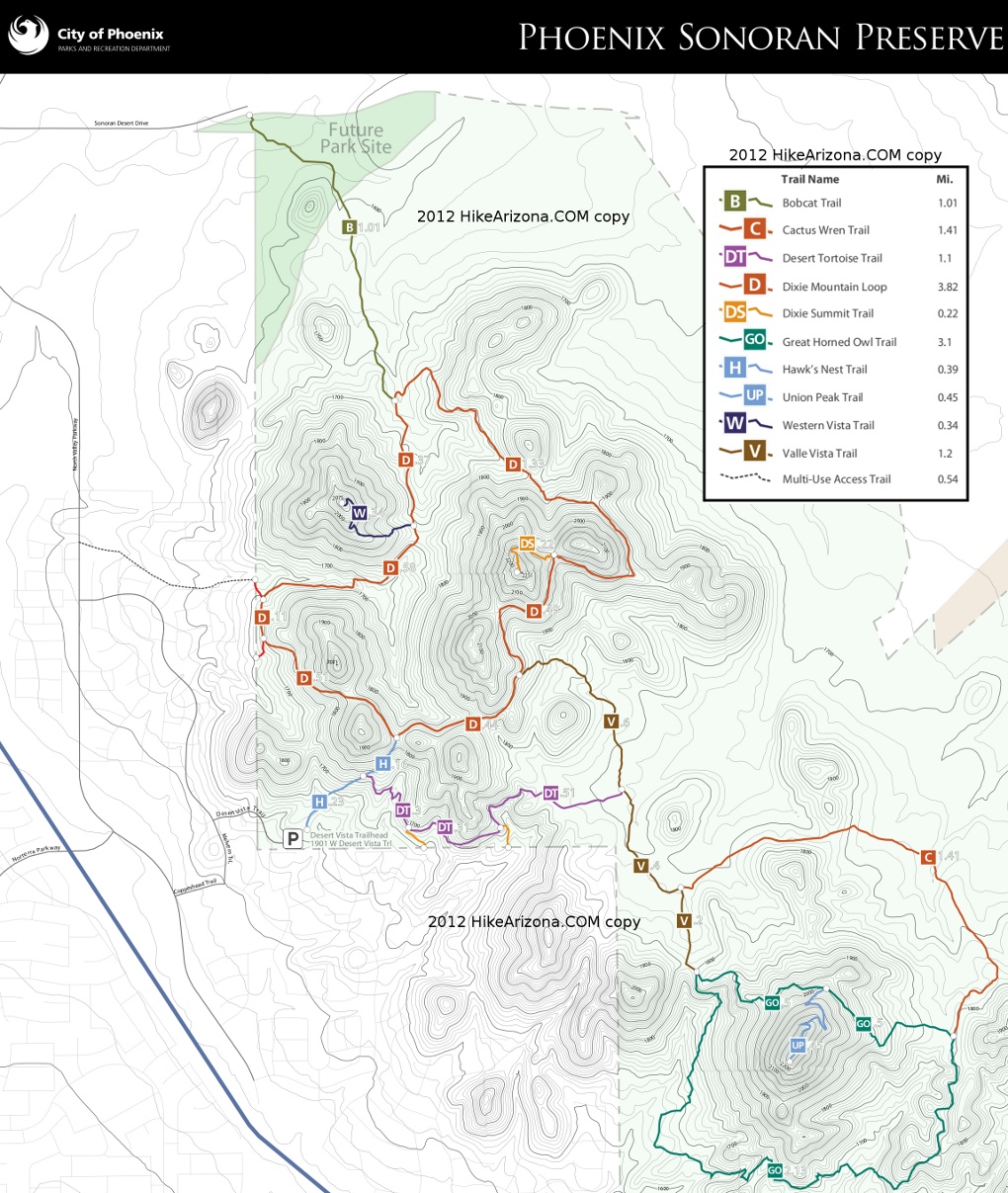
Sonoran Preserve - Desert Vista
|
7.79 mi
1,571 ft |
 |
|
Western Vista Trail - Sonoran Pre...
|
10.28 mi
1,680 ft |
|
|
Great Horned Owl Trail - Sonoran ...
|
10.85 mi
1,459 ft |
|
|
Union Dixie and one makes Three
|
11.66 mi
2,175 ft |
|
|
Tortoise Vista Wren GO Lasso
|
6.24 mi
660 ft |
|
|
Phoenix Sonoran Preserve South
|
10.18 mi
1,954 ft |
|
|
Union Peak
|
6.16 mi
932 ft |
|
|
Phoenix Sonoran Preserve South
|
10.33 mi
1,915 ft |
|
|
Sonoran Preserve Loop
|
5.88 mi
839 ft |
|
|
Tortoise UP Loop plus - Valle Dixie
|
7.81 mi
1,077 ft |
|
|
Union Peak Trail - Sonoran Preserve
|
6.76 mi
1,049 ft |
|
|
Dixie Mountain Loop - Valle and T...
|
6.13 mi
890 ft |
|
|
Sonoran Preserve
|
7.59 mi
1,323 ft |
|
| Great Horned Owl Trail - Sonoran ...
|
10.28 mi
1,162 ft |
|
|
|
Tortoise - Valle - Dixie Loop
|
6.44 mi
903 ft |
|
|
Dixie Peak - Valle - Cactus - Tor...
|
6.78 mi
1,039 ft |
|
|
Union Peak and Loop
|
7.74 mi
1,069 ft |
|
|
Desert Tortoise - Valle - Dixie P...
|
6.52 mi
1,077 ft |
|
|
Phoenix Sonoran Preserve South
|
10.33 mi
1,893 ft |
|
|
Phoenix Sonoran Preserve S - Vist...
|
10.07 mi
1,685 ft |
|
|
Sonoran Preserve - 3 Peaks
|
11.59 mi
2,032 ft |
|
|
Penance Hike - Union Hills Loop
|
7.05 mi
933 ft |
|
|
Dixie Loop plus Valle and Tortoise
|
6 mi
890 ft |
|
|
Dixie-Western-Valle-Tortoise
|
7 mi
1,245 ft |
|
|
Dixie Mountain Loop plus
|
7.38 mi
1,185 ft |
|
|
Tortoise Valle Dixie Bobcat Hawks
|
8.72 mi
1,257 ft |
|
|
Tortoise Owl Union Cactus Valle H...
|
7.28 mi
1,033 ft |
|
|
Great Horned Tortoise - Union Pea...
|
8.41 mi
1,133 ft |
|
|
Dixie Mountain Loop plus
|
6.89 mi
973 ft |
|
| Phoenix Sonoran Preserve
|
12.57 mi
2,364 ft |
|
|
|
Hawk Valle Union Tortoise
|
6.1 mi
973 ft |
|
|
Union Peak Loop plus
|
7.49 mi
1,097 ft |
|
|
Union Peak-Great Horned Owl Plus
|
8.21 mi
1,280 ft |
|
|
Cactus Wren Trail - Sonoran Preserve
|
7.73 mi
807 ft |
|
|
Dixie Mountain Loop - Tortoise
|
6.54 mi
1,104 ft |
|
|
Phoenix Sonoran Preserve Loop Union
|
10.93 mi
1,708 ft |
|
|
Union-Dixie-Western Vista
|
11.32 mi
1,894 ft |
|
|
Dixie Loop - Valle - Desert Tortoise
|
5.92 mi
901 ft |
|
|
Desert - Union - Dixie Mountain Loop
|
9.02 mi
1,437 ft |
|
|
Desert Tortoise Dixie Mountain Loop
|
6.77 mi
1,120 ft |
|
| Hawk's Nest Trail - Sonoran Preserve
|
7.01 mi
961 ft |
|
|
| Union Peak
|
7.03 mi
868 ft |
|
|
| Great Horned Owl Double Lollipop ...
|
7.91 mi
1,140 ft |
|
|
| Union Hills Loop
|
10.26 mi
2,003 ft |
|
|
| Union Peak Loop - PSP - Phoenix
|
8.34 mi
802 ft |
|
|
| Union Peak Trail - Sonoran Preserve
|
7.38 mi
1,021 ft |
|
|
| Union Peak Loop-West
|
7.11 mi
1,145 ft |
|
|
| Pk 2144 and 2111
|
9.81 mi
1,772 ft |
|
|
| Union Hills Loop
|
7.73 mi
1,087 ft |
|
|
| Cactus Wren Loop
|
6.32 mi
734 ft |
|
|
| Union Hills Loop
|
6.12 mi
924 ft |
|
|
| Cactus Wren-Great Horned Owl Trails
|
7.57 mi
848 ft |
|
|
| Desert Vista to Union Peak Sonora...
|
11.11 mi
1,355 ft |
|
|
| Circle Tank Loop
|
12.71 mi
903 ft |
|
|
| The Union Hills
|
11.32 mi
2,062 ft |
|
|
| Sonoran Preserve - Peak 2383
|
9.9 mi
1,023 ft |
|
|
| Tin Can Tank via Peak 2383
|
10.18 mi
1,147 ft |
|
|
| Great Horned Owl Trail - Sonoran ...
|
8.09 mi
933 ft |
|
|
| Union Peak Trail - Sonoran Preserve
|
5.89 mi
861 ft |
|
|
| Sonoran Preserve to the Dam
|
10.21 mi
1,272 ft |
|
|
| Sonoran Preserve - Peak 2383
|
6.02 mi
951 ft |
|
|
| Union Peak Trail - Sonoran Preserve
|
8.57 mi
1,138 ft |
|
|
| The Union Hills
|
10.54 mi
1,748 ft |
|
|
| Phoenix Sonoran Desert Preserve
|
6.37 mi
747 ft |
|
|
| Desert Tortoise Trail / Union Hil...
|
2.85 mi
394 ft |
|
|
| Great Horned Owl Loop
|
3.31 mi
435 ft |
|
|
| The Union Hills
|
12.76 mi
2,137 ft |
|
|
| Phoenix Sonoran Preserve Peaks
|
9.98 mi
1,991 ft |
|
|
| Union Peak via Desert Tortoise Trail
|
6.25 mi
917 ft |
|
|
| War Between the States hike
|
10.15 mi
1,993 ft |
|
|
| Union Peak Trail - Sonoran Preserve
|
6.03 mi
1,120 ft |
|
|
| Little Loop - Sonoran Preserve
|
2.84 mi
385 ft |
|
|
| Union Peak Trail - Sonoran Preserve
|
6.91 mi
913 ft |
|
|
| Sonoran Preserve - Peak 2383
|
5.88 mi
952 ft |
|
|
| Sonoran Preserve - Peak 2383
|
7.65 mi
1,056 ft |
|
|
 Route Editor

 Overview


