One of my favorites in the Phx Preserves by joebartels
History
Ruth Hamilton fought for the creation of the preserves.
Hike
From the west end, Ruth begins about 0.1 mi into the eastern-side of Nature Trail #304. Two short switchbacks are relaxing trail. Then the footing is rocky and variable for a few strides.
The trail gently roller coasters up to Ruth's Saddle. Tread is rough and jagged in spots, not great for running. It might be slow to challenging for children with short legs. Families with young children new to hiking typically hike the western-side of nearby Nature Trail #304. After two short steep sections, you reach Ruth's Saddle.
Continuing East down to Quartz Ridge Trail #8A is the worst tread. Sometimes this side is lightly busy. Keep an eye on footing and traffic. Hikers on #8A can't resist the short side trip up to Ruth's Saddle to see the jewel of the preserves, Piestewa Peak.
Once down to the junction at Quartz Saddle, continue ENE, straight across and slightly left. Soon it's obvious you are on an old jeep road. Views North and East are, in my opinion, among the best inner-city steep mountainside views. The hike to 36th St is easy and relaxing. 36th St is gated in a neighborhood. A left along 36th connects with LV Yates Trail #8.
Synopsis
Overall I typically see occasional hikers in nice weather. Rarely if ever crowded. Ghost townish in warm to hot weather. Most hikers encountered are laid-back and easygoing compared to Piestewa and Camelback summit trails.
It's a nice out and back hike. You can loop SW with Mohave Connector Trail #202 or NE with LV Yates Trail #8. An out-n-back with Piestewa Peak from several inner preserve parking lots is about 5.25 mi / 2K.
Gate Policy: If a gate is closed upon arrival, leave it closed after you go through. If it is open, leave it open. Leaving a closed gate open may put cattle in danger. Closing an open gate may cut them off from water. Please be respectful, leave gates as found. The exception is signage on the gate directing you otherwise.
When hiking several trails on a single "hike", log it with a generic name that describes the hike. Then link the trails traveled, check out the example.
WARNING! Hiking and outdoor related sports can be dangerous. Be responsible and prepare for the trip. Study the area you are entering and plan accordingly. Dress for the current and unexpected weather changes. Take plenty of water. Never go alone. Make an itinerary with your plan(s), route(s), destination(s) and expected return time. Give your itinerary to trusted family and/or friends.
Permit $$
None
Directions
Road
Paved - Car Okay
To hike This trail takes off shortly up the Nature Trail #304
page created by HAZ_Hikebot on Feb 08 2010 9:24 pm
 Route Editor

 History
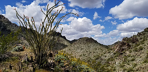


