| | -
| 1 label | 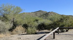 |
|
|
-
-
-
-
-
-
| 1 label | 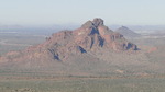 |
|
|
-
-
| 1 label |  |
|
3 |
|
| | |
|
| Hiking | 2.00 Miles |
800 AEG |
| | Hiking | 2.00 Miles | 2 Hrs | | 1.00 mph |
| 800 ft AEG | | | | |
|
|
| |
| Linked |
|
none
[ show ]
| no linked trail guides |
| Partners |
|
none
[ show ]
| no partners | | This is an easy morning hike that would be a good introductory hike for the novice peakbagger. From the summit and looking clockwise you can see:
The Mazatzals, Mt. Ord, Stewart Mountain, Lower Salt River, Saguaro Lake, Goldfields, Weaver's Needle, The Flatiron, The north side of Pass Mountain, The San Tans, Usery Mountains, South Mountain, Sierra Estrellas, Downtown Phoenix, Camelback, White Tank Mountains, Red Mountain, The McDowells, Fountain Hills, The Bradshaw Mountains... and plenty more points of interest that I'm sure I missed. |
| _____________________
"I've driven across deserts, driven by the irony, that only being shackled to the road could ever I be free"
- Frank Turner "The Road" |
| | |
|
|
|
|
|
| |
 Route Editor


