| |
| UnNamed Canyon Meander - Sierra Ancha, AZ | | -
-
| |  |
|
1 |
-
-
| |  |
|
2 |
-
|
| | UnNamed Canyon Meander - Sierra Ancha, AZ | | | |
|
|
UnNamed Canyon Meander - Sierra Ancha, AZ
| | |
|
| Hiking | 1.60 Miles |
|
| | Hiking | 1.60 Miles | | | |
| | | |
| |
| Partners |
|
[ show ]
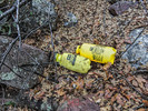
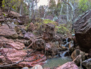
| partners | | Hank and I had come back to Camp Grasshopper in Upper Cherry Creek Canyon a little early this afternoon after a day of hiking. Hank started fixing us a spaghetti dinner so I decided to help by getting out of his way and took a walk up what we call "UnNamed Canyon". I give Hank credit for being a partner on this hike since he was busy fixing us dinner. I headed through a gate in the fence behind camp and followed cow trails along a bench that parallels the UnNamed Cny creek. This fence may mark the boundary of the SA Wilderness. There is a forest of tall trees in this area, oak, juniper and sycamore, due to an unnamed spring/seep which soaks a fairly large area. Along the way I checked out the spring area and noted a section of old road grade through this area. It may have been the old road before the newer FR203 was built with funding from the Atomic Energy Commission in the early 1950s. It was fairly easy going with cow trails to follow and very little brush under the canopy of tall trees. This all ended when I got to the canyon narrows. At his point the canyon bottom is littered with large boulders which the steep canyon side makes it difficult to bypass. Here I found evidence of gardening activity - two plastic garden spray cans lying below a large boulder where they had probably been deposited by high water. Sections of tangled black tubing used for drip irrigation were wrapped around trees and boulders in the flood zone of the creek. I had expected this because RedRoxx44 had seen similar stuff in a similar side canyon. [ photoset ] This area was too accessible for a grow site so I suspect the gardening supplies had been washed down stream by flood waters. It was getting close to dinner time so I headed back to camp. Besides, the boulder strewn creek bottom looked like a good place to break a leg. I headed through a gate in the fence behind camp and followed cow trails along a bench that parallels the UnNamed Cny creek. This fence may mark the boundary of the SA Wilderness. There is a forest of tall trees in this area, oak, juniper and sycamore, due to an unnamed spring/seep which soaks a fairly large area. Along the way I checked out the spring area and noted a section of old road grade through this area. It may have been the old road before the newer FR203 was built with funding from the Atomic Energy Commission in the early 1950s. It was fairly easy going with cow trails to follow and very little brush under the canopy of tall trees. This all ended when I got to the canyon narrows. At his point the canyon bottom is littered with large boulders which the steep canyon side makes it difficult to bypass. Here I found evidence of gardening activity - two plastic garden spray cans lying below a large boulder where they had probably been deposited by high water. Sections of tangled black tubing used for drip irrigation were wrapped around trees and boulders in the flood zone of the creek. I had expected this because RedRoxx44 had seen similar stuff in a similar side canyon. [ photoset ] This area was too accessible for a grow site so I suspect the gardening supplies had been washed down stream by flood waters. It was getting close to dinner time so I headed back to camp. Besides, the boulder strewn creek bottom looked like a good place to break a leg. |
| _____________________
| | |
|
|
|
|
|
| |
 Route Editor


