| | -
-
-
-
-
-
-
-
-
-
-
-
| 1 label | 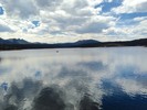 |
|
|
-
-
-
| 1 label | 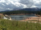 |
|
|
|
| | |
|
| Hiking | 15.27 Miles |
4,018 AEG |
| | Hiking | 15.27 Miles | | | |
| 4,018 ft AEG | | | | |
|
|
| |
| Linked |
|
none
[ show ]
| no linked trail guides |
| Partners |
|
none
[ show ]
| no partners | | Best pumpkin loop from my house. When doing the family hike up Dewey last time home. I saw on the map that it supposedly went to north Catamount Reservoir. John 9L would be proud of the trails I linked. I hit every trail from my house to north catamount. If I ever get some time I might actually get the trails on hike az. So I can actually link them.  Mt Esther Ring the Peak crystal trail Kirkpatrick trail through town and btw Bronc Days are going on. Dewey Mtn trail to rtp to catamount creek to Thomas trail to Ute pass regional trail. Dewey trail was almost completed with flags the last hundred yards. After getting past the summit the trail was much less used. Not many switchbacks. Dewey all the way to N Catamount was extremely warm thanks to the south facing ridges. Thought I was hiking in Az. Hit the waterfalls on the way back. Not too many places with this much variety out the front door. Mt Esther Ring the Peak crystal trail Kirkpatrick trail through town and btw Bronc Days are going on. Dewey Mtn trail to rtp to catamount creek to Thomas trail to Ute pass regional trail. Dewey trail was almost completed with flags the last hundred yards. After getting past the summit the trail was much less used. Not many switchbacks. Dewey all the way to N Catamount was extremely warm thanks to the south facing ridges. Thought I was hiking in Az. Hit the waterfalls on the way back. Not too many places with this much variety out the front door. |
|
Wildflowers Observation Moderate
Moderate |
|
| _____________________
| | |
|
|
|
|
|
| |
 Route Editor


